
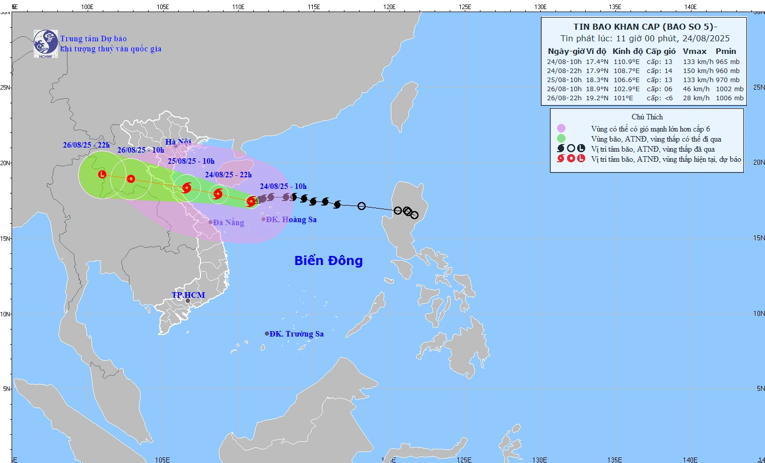
Map of the path and intensity of storm No. 5 at 11:00 on August 24, 2025.
Specifically, at 10:00 a.m. on August 24 , the storm center was at 17.4 degrees North latitude, 110.9 degrees East longitude, in the Northwestern Hoang Sa sea, about 580km from Nghe An, about 560km East Southeast of Ha Tinh .
The strongest wind is level 12-13 (118-149 km/h), gusting to level 15. The storm is moving west at a speed of about 20 km/h.
Forecast, by 10pm on August 24 , the storm will move West Northwest at about 20km/h, at 17.9 degrees North latitude, 108.7 degrees East longitude (South of Tonkin Gulf), 300km from Nghe An , 270km from Ha Tinh. Intensity level 13-14, gust level 16. Dangerous area: 16-20 degrees North latitude; West of 112.5 degrees East longitude. Risk level 3 in the Northwestern sea of the East Sea, Tonkin Gulf and the sea from South Quang Tri to Hue (including Hon Ngu, Con Co).
At 10:00 a.m. on August 25 , the storm center was at 18.3 degrees North latitude, 106.6 degrees East longitude, in the sea area from Thanh Hoa to Quang Tri . Intensity level 12-13, gust level 15. Dangerous area: 16-20 degrees North latitude; West 112.5 degrees East longitude. Risk level 3 in the East Sea, Gulf of Tonkin, South Quang Tri - Hue and level 4 in the coastal waters from Thanh Hoa to Quang Tri.
At 10:00 a.m. on August 26, the storm moved west-northwest at a speed of 15-20 km/h, gradually weakening, at 18.9 degrees North latitude, 102.9 degrees East longitude (Laos-Thailand border). Intensity level 6, gust level 8. Dangerous area: 16-20 degrees North latitude; west of 108.5 degrees East longitude. Risk level 3 in the Gulf of Tonkin, South Quang Tri - Hue; level 4 in the coastal areas of Thanh Hoa - Quang Tri and the mainland from Thanh Hoa to North Quang Tri.
By 10 p.m. on August 26, storm No. 5 is forecast to weaken into a low pressure area, then a low pressure area at 19.2 degrees North latitude, 101 degrees East longitude, in the upper Laos region.
Forecasting the impact of storms
At sea:
Northwest East Sea (including Hoang Sa): wind level 9-11, near storm center 12-14, gust level 16; waves 5-7m high, near center 8-10m, rough sea.
From noon today, August 24, the sea area of Thanh Hoa - Hue (Hon Ngu, Con Co) has winds of level 7-9, then increasing to level 10-11, near the storm center level 12-14, gusting to level 16; waves 5-7m high, near the storm center up to 8-10m high, rough seas.
On the afternoon of August 24, in the North of Bac Bo Gulf (Cat Hai, Co To, Van Don), the wind is level 6-7, gusting to level 9; in the South (Bach Long Vi), the wind is level 8-9, gusting to level 11; waves are 2.5-4.5m high, and the sea is very rough.
Coastal areas:
Coastal Hai Phong - Northern Quang Tri water level rises 0.5-1.5m.
Water levels at stations: Hon Dau 3.3–3.8m; Ba Lat 1.7–2.1m; Sam Son 3.2–3.7m; Hon Ngu 3.2–3.6m; Cua Nhuong 2.2–2.6m.
High risk of flooding in low-lying areas, coastal areas, and river mouths on the evening of August 25.
The meteorological agency warns: the sea and coastal areas are extremely dangerous, unsafe for boats, rafts, and coastal structures; there is a great risk of capsizing, destruction, and flooding. | |
On land:
From the night of August 24: Thanh Hoa - Quang Tri wind level 8-10, near the storm center level 11-13, gusting to level 14-15. Coastal Quang Ninh - Ninh Binh strong wind level 6-8, gusting to level 9.
From August 24-26: Northern Delta, South Phu Tho, Thanh Hoa - Hue rain 100-150mm, some places over 250mm.
In the Thanh Hoa - Northern Quang Tri region, rainfall reached 200-400mm, in some places over 700mm.
Risk of extremely heavy rain (over 200mm in 3 hours).
From August 25-26: Hanoi, Da Nang moderate to heavy rain, thunderstorms. Ho Chi Minh City late afternoon showers, thunderstorms.
From August 25-27: Upper and central Laos will have 100-250mm of rain, with some places having over 500mm.
NM
Source: https://baothanhhoa.vn/bao-so-5-cach-nghe-an-580-km-giat-cap-15-259240.htm


![[Photo] 60th Anniversary of the Founding of the Vietnam Association of Photographic Artists](/_next/image?url=https%3A%2F%2Fvphoto.vietnam.vn%2Fthumb%2F1200x675%2Fvietnam%2Fresource%2FIMAGE%2F2025%2F12%2F05%2F1764935864512_a1-bnd-0841-9740-jpg.webp&w=3840&q=75)


![[Photo] National Assembly Chairman Tran Thanh Man attends the VinFuture 2025 Award Ceremony](/_next/image?url=https%3A%2F%2Fvphoto.vietnam.vn%2Fthumb%2F1200x675%2Fvietnam%2Fresource%2FIMAGE%2F2025%2F12%2F05%2F1764951162416_2628509768338816493-6995-jpg.webp&w=3840&q=75)


![[E-Magazine]: The Sound of Dawn](https://vphoto.vietnam.vn/thumb/402x226/vietnam/resource/IMAGE/2025/12/05/1764941867640_e-magazine-than-w1200t0-di2548d199d5160111t11920l1-tabm-024.webp)


Comment (0)