
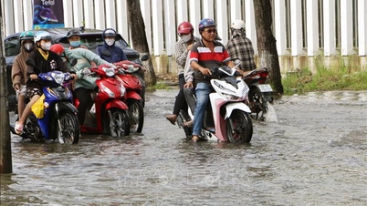
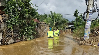
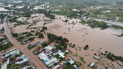
Very heavy rain causes high risk of flooding
On the afternoon of August 25, Nghe An Province's Hydrometeorological Station issued a flood warning in the province after recording very heavy rainfall over the past several hours.
According to data from automatic rain gauges, from 9am to 3pm on August 25, many places had heavy to very heavy rain. The amount of rain measured at some particularly high points such as Cho Trang was 175.4mm, Hoang Mai 167.2mm, and Nam Thanh 1 was 154.6mm.
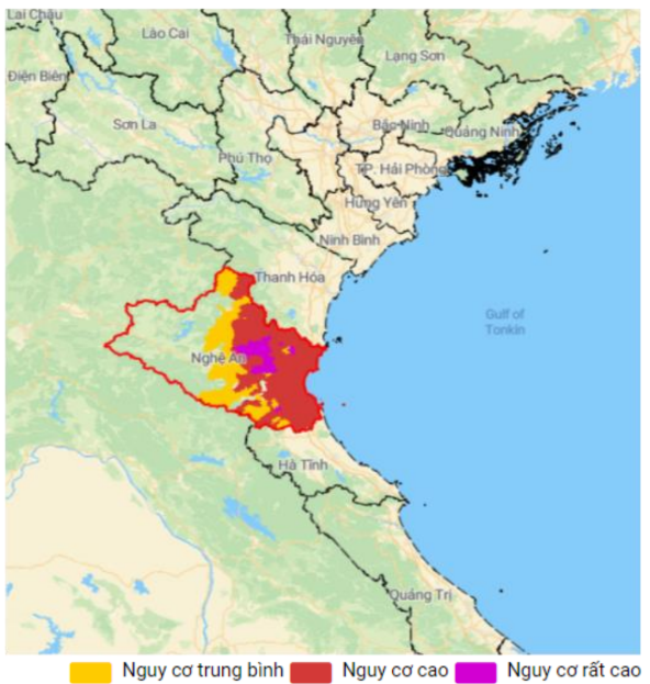
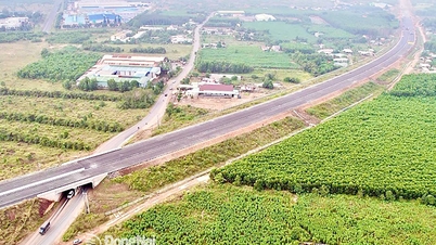
The meteorological agency warned of a high risk of flooding in low-lying areas, urban areas and riverside areas across Nghe An province.
Flooding is likely to last until August 26. Flood depth is forecast to be between 0.5 and 1.0 meters, with some areas possibly being deeper than 1.0 meters.
The flood disaster risk level is determined at Level 1.
Residents are advised to be on guard against flooding which could cause damage to homes and property, as well as serious damage to crops and livestock. Flooding could also cause disruption and danger to traffic.
Storm No. 5 moves slowly, wind force level 12
The situation became especially dangerous when the news flash at 3 p.m. the same day said that storm number 5 was active right on the coast of Nghe An - Ha Tinh area.
- Storm center location: About 18.4 degrees North latitude; 106.1 degrees East longitude.
- Strongest wind: Level 12 (118-133km/h), gust level 14-15.
- Forecast: In the next 3 hours, the storm is forecast to move west at a speed of about 10-15km/h.
List of communes and wards at risk of flooding in Nghe An province:
Dong Hieu, Giai Xuan, Minh Hop, Muong Chong, Muong Ham, Nghia Dong, Nghia Hung, Nghia Khanh, Tay Hieu Ward, Quy Hop, Tam Hop, Tan An, Tan Ky, Tan Phu, Xuan Lam, An Chau, Anh Son, Anh Son Dong, Bach Ha, Bach Ngoc, Bich Hao, Binh Minh, Cat Ngan, Chau Binh, Chau Hong, Chau Loc, Chau Tien, Dai Dong, Dai Hue, Dien Chau, Do Luong, Dong Loc, Dong Thanh, Duc Chau, Giai Lac, Hai Chau, Hai Loc, Hanh Lam, Hoa Quan, Hop Minh, Hung Chan, Hung Chau, Hung Nguyen, Kim Bang, Kim Lien, Lam Thanh, Luong Son, Minh Chau, Nam Dan, Nghi Loc, Nghia Dan, Nghia Hanh, Nghia Lam, Nghia Loc, Nghia Mai, Nghia Tho, Cua Lo Ward, Hoang Mai Ward, Quynh Mai Ward, Tan Mai Ward, Thai Hoa Ward, Thanh Vinh Ward, Truong Vinh Ward, Vinh Hung Ward, Vinh Loc Ward, Vinh Phu Ward, Phuc Loc, Quan Thanh, Quang Chau, Quang Dong, Quy Chau, Quynh Anh, Quynh Luu, Quynh Phu, Quynh Son, Quynh Tam, Quynh Thang, Quynh Van, Tam Dong, Tan Chau, Than Linh, Thanh Binh Tho, Thien Nhan, Thong Thu, Thuan Trung, Tien Dong, Tien Phong, Trung Loc, Van An, Van Du, Van Hien, Van Kieu, Van Tu, Vinh Tuong, Yen Thanh, Yen Trung, Yen Xuan, Binh Chuan, Cam Phuc, Con Cuong, Mau Thach, Mon Son, Muong Quang, Nga My, Nhan Hoa, Que Phong, Son Lam.
Source: https://baonghean.vn/bao-so-5-suc-gio-cap-12-giat-cap-14-15-nghe-an-canh-bao-ngap-lut-tren-dien-rong-10305195.html
![[Photo] Cat Ba - Green island paradise](/_next/image?url=https%3A%2F%2Fvphoto.vietnam.vn%2Fthumb%2F1200x675%2Fvietnam%2Fresource%2FIMAGE%2F2025%2F12%2F04%2F1764821844074_ndo_br_1-dcbthienduongxanh638-jpg.webp&w=3840&q=75)


Comment (0)