
According to monitoring data over the past 24 hours, in Khanh Hoa , the average rainfall was 50 - 120 mm; some places recorded exceptionally heavy rain such as Khanh Hiep 200.3 mm, Son Thai 135 mm, Da Nhim 134.4 mm, Khanh Phu 129.4 mm. Heavy rain caused water levels on rivers to fluctuate strongly, causing small floods; in particular, Cai Phan Rang River in Tan My reached alert level 1 - 2 and continued to rise. At Dong Trang station (Cai Nha Trang River), the water level also increased rapidly on the morning of December 4.

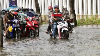
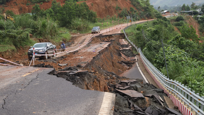
Many places in Khanh Hoa were submerged in water during the recent flood.
PHOTO: HL
Regarding reservoirs, the total capacity of 64 lakes in the area reached 621.19 million m³, equivalent to 82.6% of the design capacity. Many large lakes such as Da Ban, Suoi Dau, Song Cai, Song Sat, and Song Trau are storing water at 76-87% and operating simultaneously to regulate. In the south of the province, Song Cai reservoir discharged 19.67 m³/s, Tra Co reservoir 103.78 m³/s, Tan Giang reservoir 156.59 m³/s; in the north, Hoa Son reservoir discharged 11.8 m³/s, Da Ban reservoir 7.6 m³/s, Suoi Dau reservoir 20.45 m³/s, etc.
Forecast for the day and night of December 4, Khanh Hoa continues to be cloudy, with moderate to heavy rain. The northern part of the province will have rainfall of 20 - 40 mm, in some places over 60 mm; the southern part of the province will have rainfall of 30 - 50 mm, locally over 90 mm. Offshore, there will be strong winds of level 5, sometimes level 6, gusting to level 7 - 8; waves 2 - 4 m high, rough seas. In the Truong Sa area, there will be northeast winds of level 4 - 5, gusting to level 6.
Floods on rivers are forecast to continue to rise. The flood peak is likely to be at alert level 1; the Cai Phan Rang and Cai Nha Trang rivers alone may exceed alert level 2.
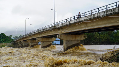
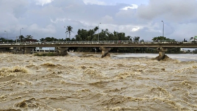
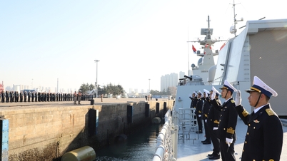
Many reservoirs in Khanh Hoa continue to overflow, risking widespread flooding

Water level on Cai River in Nha Trang may exceed alert level 2
PHOTO: HL
The risk of flash floods and landslides is warned at a high level in many mountainous and midland areas such as Van Hung, Van Thang, Dai Lanh, Tay Ninh Hoa, Dong Ninh Hoa, Suoi Hiep, Cam An, Suoi Cat, Bac Khanh Vinh, Tay Khanh Vinh, Trung Khanh Vinh, Khanh Son, Dong Khanh Son, Tay Khanh Son, Lam Son, Bac Ai, Ninh Son... These are all areas with steep terrain, loose rocks and soil and landslides have occurred in previous heavy rains.
In addition, the risk of localized flooding may occur in many low-lying and urban areas including Dien Khanh, Suoi Hiep, Dien Dien, North Nha Trang, central Nha Trang area, West Nha Trang, South Nha Trang, Phan Rang, Bao An, Ninh Phuoc, Phuoc Dinh, Phuoc Hau, Phuoc Huu, Thuan Nam, Cam Ranh... The highest tide level is forecast to reach 1.7 m at around 8-9 pm, which may cause water to rise and increase the risk of flooding.
Source: https://thanhnien.vn/nhieu-ho-chua-tai-khanh-hoa-tiep-tuc-xa-tran-nguy-co-ngap-ung-dien-rong-185251204072220851.htm


![[Photo] Cat Ba - Green island paradise](/_next/image?url=https%3A%2F%2Fvphoto.vietnam.vn%2Fthumb%2F1200x675%2Fvietnam%2Fresource%2FIMAGE%2F2025%2F12%2F04%2F1764821844074_ndo_br_1-dcbthienduongxanh638-jpg.webp&w=3840&q=75)


![[VIMC 40 days of lightning speed] Da Nang Port: Unity - Lightning speed - Breakthrough to the finish line](https://vphoto.vietnam.vn/thumb/402x226/vietnam/resource/IMAGE/2025/12/04/1764833540882_cdn_4-12-25.jpeg)


Comment (0)