
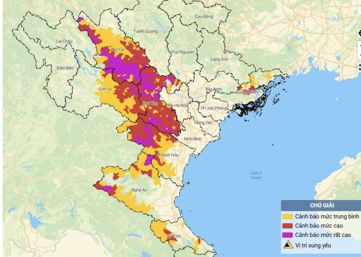
Map of flash flood and landslide risk in the areas.
From 8:00 p.m. on August 25 to 8:00 p.m. on August 26, the above provinces experienced moderate to heavy rain, and in some places very heavy rain. The soil moisture model shows that some areas are nearly saturated (over 85%) or have reached a saturated state.
It is forecasted that in the next 3-6 hours, the above provinces will continue to have rain with accumulated rainfall in Lao Cai, Son La, Quang Ninh at 10-20mm, some places over 40mm; Phu Tho 30-60mm, some places over 90mm; from Thanh Hoa to Ha Tinh 10-25mm, some places over 50mm.
Warning in the next 6 hours, there is a risk of flash floods on small rivers and streams, landslides on steep slopes in many communes and wards.
Of which, Thanh Hoa province has 77/166 communes and wards on the warning list, including: Hoi Xuan, Phu Le, Phu Xuan, Son Dien, Tam Lu, Tam Thanh, Thiet Ong, Trung Ha, Van Nho, Van Phu, Yen Thang; Ba Thuoc, Cam Tu, Co Lung, Dien Lu, Dien Quang, Dong Luong, Giao An, Hien Kiet, Linh Son, Luong Son, Muong Min, Nam Xuan, Ngoc Lac, Nhi Son, Pu Luong, Quan Son, Quy Luong, Son Thuy, Tam Chung, Tan Thanh, Thach Binh, Thach Quang, Thang Loc, Thanh Vinh, Thien Phu, Trung Ly, Trung Son, Trung Thanh, Van Xuan, Yen Khuong; Bat Mot, Cam Tan, Cam Thach, Cam Thuy, Cam Van, Cong Chinh, Hoa Quy, Kien Tho, Luan Thanh, Mau Lam, Minh Son, Muong Chanh, Muong Lat, Muong Ly, Na Meo, Ngoc Lien, Ngoc Trao, Nguyet An, Nhu Thanh, Nhu Xuan, Pu Nhi, Quang Chieu, Tay Do, Thach Lap, Thanh Phong, Thanh Quan, Thuong Ninh, Thuong Xuan, Van Du, Xuan Chinh, Xuan Du, Xuan Thai, Xuan Tin, Yen Nhan, Yen Phu, Yen Tho.
Warning level of natural disaster risk due to flash floods, landslides, land subsidence due to heavy rain or water flow: level 1; Phu Tho and Thanh Hoa level 2.
See the list of areas at risk of flash floods and landslides here.
NM
Source: https://baothanhhoa.vn/canh-bao-77-xa-khu-vuc-thanh-hoa-co-nguy-co-xay-ra-lu-quet-sat-lo-259656.htm
![[Photo] National Assembly Chairman Tran Thanh Man receives Chairman of the House of Representatives of Uzbekistan Nuriddin Ismoilov](https://vphoto.vietnam.vn/thumb/1200x675/vietnam/resource/IMAGE/2025/10/27/1761542647910_bnd-2610-jpg.webp)


![[Photo] The 5th Patriotic Emulation Congress of the Central Inspection Commission](https://vphoto.vietnam.vn/thumb/1200x675/vietnam/resource/IMAGE/2025/10/27/1761566862838_ndo_br_1-1858-jpg.webp)
![[Photo] Party Committees of Central Party agencies summarize the implementation of Resolution No. 18-NQ/TW and the direction of the Party Congress](https://vphoto.vietnam.vn/thumb/1200x675/vietnam/resource/IMAGE/2025/10/27/1761545645968_ndo_br_1-jpg.webp)


Comment (0)