
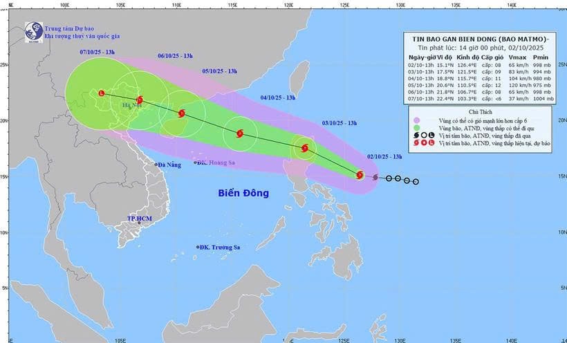
According to the National Center for Hydro-Meteorological Forecasting, at 1:00 a.m. on October 2, the center of the tropical depression was located in the sea east of the Philippines. The strongest wind near the center of the tropical depression was level 7 (50-61 km/h), gusting to level 9.
It is forecasted that during today and tonight (October 2), the tropical depression will move in a West Northwest direction at a speed of about 20km/h and is likely to strengthen into a storm.
At 1am tomorrow morning (October 3), the storm center will be in the sea east of Luzon Island, with storm intensity at level 8, gusting to level 10.
When entering the East Sea, storm No. 11 is forecast to encounter favorable conditions of high sea surface temperature (29-30 degrees Celsius) and weak winds above, making the storm likely to strengthen to level 12-13.
See detailed dispatch here
Source: https://baolamdong.vn/chu-tich-ubnd-tinh-lam-dong-chi-dao-khan-truong-ung-pho-voi-ap-thap-nhet-doi-gan-bien-dong-394222.html


![[Photo] General Secretary To Lam and National Assembly Chairman Tran Thanh Man attend the 80th Anniversary of the Traditional Day of the Vietnamese Inspection Sector](https://vphoto.vietnam.vn/thumb/1200x675/vietnam/resource/IMAGE/2025/11/17/1763356362984_a2-bnd-7940-3561-jpg.webp)


Comment (0)