
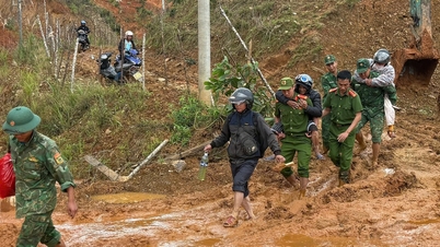
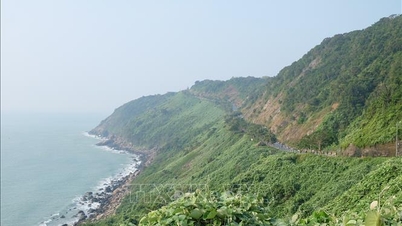
On the evening of November 4, the Management Board of Son Tra Peninsula and Da Nang tourist beaches said that due to the impact of heavy rain in recent days, some locations on Son Tra Peninsula have experienced landslides and rolling rocks on the roads to Ban Co peak and Suoi Om area.
Specifically, the Yet Kieu - Ban Co peak route has 1 landslide point about 100 m from the Forest Ranger Station; the Ban Co peak - InterContinental Da Nang route has a landslide point about 3 km long; the Tien Sa - Suoi Om - Ban Co peak route has 2 landslide points, located about 500 m from Suoi Om. Only the Cay Da Ngan Nam and Ho Sau routes have no landslides recorded.

Scene of serious landslide on Tien Sa - Suoi Om route in Son Tra peninsula
PHOTO: SX
Mr. Phan Minh Hai, Deputy Head of the Management Board of Son Tra Peninsula and Da Nang tourist beaches, added that on the route to InterContinental Da Nang at the flower garden location, there is a high risk of landslides due to cracks in the embankment.
For now, the Management Board has placed warning signs and put up warning tape. The local police have also erected barriers to block the one-way road from InterContinental Danang to Linh Ung Pagoda.

Heavy rain puts Son Tra peninsula at risk of landslides
PHOTO: SX
Since yesterday (November 3), due to complicated weather developments, with a high risk of landslides, flash floods and fallen trees in the Son Tra peninsula area, the Management Board has announced a temporary suspension of traffic and sightseeing on all routes in the Son Tra peninsula.
The Management Board of Son Tra Peninsula and Da Nang tourist beaches recommends that residents and tourists do not move into the Son Tra Peninsula area without permission during the temporary closure. The authorities will organize checkpoints, control and guide at the frontline area to ensure the safety of residents and tourists.

Landslide at Ban Co peak - InterContinental Danang
PHOTO: SX
Regarding the situation at the tourist beaches, the Management Board said there was no damage to infrastructure. However, due to heavy rain and strong waves, a large amount of trash, duckweed and other debris washed ashore, especially along the Vo Nguyen Giap and Nguyen Tat Thanh beaches.
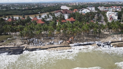
Many coastal areas such as My Khe and My An have had sand washed up onto the sidewalks by waves; Paradise Beach (My An beach) in particular is at high risk of landslides.

The road to Son Tra peninsula is extremely dangerous so the authorities have organized a road closure.
PHOTO: SX
The management board of Son Tra peninsula and Da Nang tourist beaches has requested the River and Sea Environment Enterprise to increase human resources and equipment to collect and process remaining garbage to soon restore clean and beautiful landscapes to Da Nang beaches.
Source: https://thanhnien.vn/da-lon-tran-ra-mat-duong-tam-dung-tham-quan-o-ban-dao-son-tra-185251104184614745.htm
![[Photo] The road connecting Dong Nai with Ho Chi Minh City is still unfinished after 5 years of construction.](https://vphoto.vietnam.vn/thumb/1200x675/vietnam/resource/IMAGE/2025/11/04/1762241675985_ndo_br_dji-20251104104418-0635-d-resize-1295-jpg.webp)
![[Photo] Opening of the 14th Conference of the 13th Party Central Committee](https://vphoto.vietnam.vn/thumb/1200x675/vietnam/resource/IMAGE/2025/11/05/1762310995216_a5-bnd-5742-5255-jpg.webp)
![[Photo] Panorama of the Patriotic Emulation Congress of Nhan Dan Newspaper for the period 2025-2030](https://vphoto.vietnam.vn/thumb/1200x675/vietnam/resource/IMAGE/2025/11/04/1762252775462_ndo_br_dhthiduayeuncbaond-6125-jpg.webp)


Comment (0)