
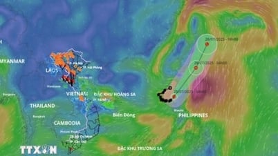
At 13:00 on October 6th, the center of Typhoon No. 4 was located at approximately 21.7 degrees North latitude and 117.0 degrees East longitude, in the northeastern part of the South China Sea, about 340km east-southeast of Hong Kong (China).
 |
| Forecasts indicate that Typhoon No. 4 will move mainly westward and west-southwestward and will gradually weaken. (Source: nchmf.gov.vn) |
Developments and impacts of Typhoon No. 4
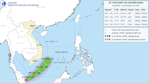
Current status of Typhoon No. 4
The strongest winds near the center of the storm are at level 12 (118-133 km/h), with gusts up to level 15, moving westward at a speed of approximately 10 km/h.
Forecast of storm developments (next 24 to 72 hours):
Forecast time | Direction, speed | Location | Intensity | Hazardous area | Level of natural disaster risk (Affected area) |
1 PM on October 7th | West, about 10 km/h and gradually slowing down. | 21.6N-114.9E, approximately 110km southeast of Hong Kong (China). | Level 9-10, level 13 | North of latitude 19.0N; 113.0-119.0E | Level 3: Northern part of the North East Sea region |
1 PM on October 8th | West-southwest, 5-10 km/h, and weakening into a tropical depression. | 21.2N-113.4E, approximately 170km southwest of Hong Kong (China). | Level 7, bursts up to level 9. | North of latitude 19.0N; 112.0-117.0E | Level 3: Northern part of the North East Sea region |
1 PM on October 9th | Southwest, 5-10 km/h, and weakening into a low-pressure area. | 20.4N-112.1E, approximately 330km southwest of Hong Kong (China). |
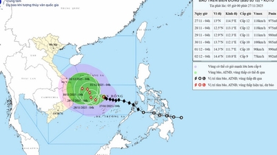
Forecast of the impact of typhoon number 4
Strong winds
At sea: In the northern part of the North East Sea, winds will be strong, reaching force 7-9, with winds near the storm's center reaching force 10-12, gusting to force 15; the sea will be extremely rough.
Rising water, big waves
In the northern South China Sea, waves are 2-4m high, with waves reaching 4.0-6.0m in the northern part of the sea, and 6-8m near the storm's center.
China maintains a level three danger alert for Typhoon Koinu.
On October 6th, the China National Meteorological Center (NMC) warned that strong winds and heavy rain would affect southern and southeastern regions of the country from the morning of October 6th to the morning of October 7th due to the influence of Typhoon Koinu.
This is the 14th typhoon to hit China this year, forecast to make landfall on the eastern coast of Guangdong province. The National Meteorological Center (NMC) is currently maintaining a yellow alert, the third most dangerous level on a four-level warning scale, for this storm.
Due to the impact of the storm, many areas in Taiwan (China), Fujian Province, and Guangdong Province will experience heavy rainfall in the next 24 hours, with predicted rainfall amounts of 50-70mm.
Meanwhile, strong winds will occur in many offshore areas, as well as along the coastal regions of Zhejiang, Fujian, and Guangdong over the next 24 hours.
The NMC urged local authorities to prepare emergency response measures for the typhoon and maintain a high level of vigilance regarding the risk of flooding and geological disasters.
Source


![[Photo] Prime Minister Pham Minh Chinh holds a phone call with the CEO of Russia's Rosatom Corporation.](/_next/image?url=https%3A%2F%2Fvphoto.vietnam.vn%2Fthumb%2F1200x675%2Fvietnam%2Fresource%2FIMAGE%2F2025%2F12%2F11%2F1765464552365_dsc-5295-jpg.webp&w=3840&q=75)


![[Photo] Closing Ceremony of the 10th Session of the 15th National Assembly](/_next/image?url=https%3A%2F%2Fvphoto.vietnam.vn%2Fthumb%2F1200x675%2Fvietnam%2Fresource%2FIMAGE%2F2025%2F12%2F11%2F1765448959967_image-1437-jpg.webp&w=3840&q=75)


![[OFFICIAL] MISA GROUP ANNOUNCES ITS PIONEERING BRAND POSITIONING IN BUILDING AGENTIC AI FOR BUSINESSES, HOUSEHOLDS, AND THE GOVERNMENT](https://vphoto.vietnam.vn/thumb/402x226/vietnam/resource/IMAGE/2025/12/11/1765444754256_agentic-ai_postfb-scaled.png)


Comment (0)