
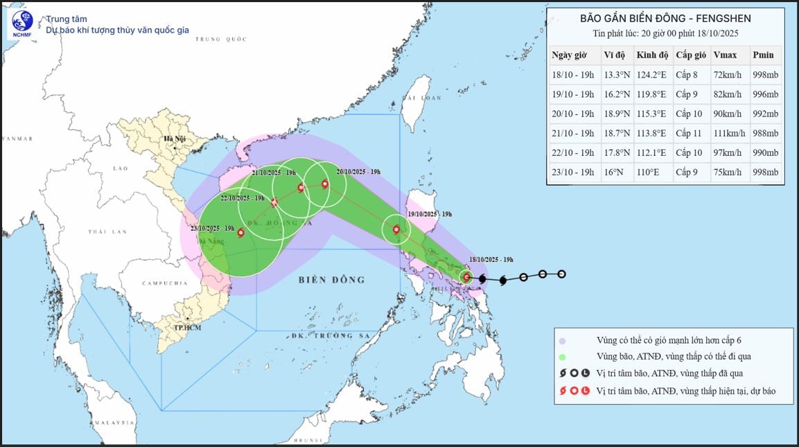
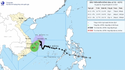
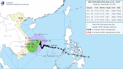
At 7:00 p.m. on October 18, the center of the storm was located at about 13.3 degrees North latitude; 124.2 degrees East longitude, in the eastern central region of the Philippines. The strongest wind near the center of the storm was level 8 (62-74 km/h), gusting to level 10. Moving in the West Northwest direction at a speed of about 20 km/h.
Forecast until 7:00 p.m. on October 19, the storm in the eastern sea of the North East Sea, wind strength level 9, gust level 11, moving northwest at a speed of about 20 km/hour and likely to strengthen.
As of 7 p.m. on October 20, the storm was in the eastern sea of the North East Sea, about 410 km east-northeast of the Hoang Sa special zone, with strong winds of level 9-10, gusting to level 13, moving northwest at a speed of about 20-25 km/h and likely to intensify. The affected area is the eastern sea of the North East Sea. Disaster risk level 3.
At 7:00 p.m. on October 21, the storm was in the North East Sea, about 270 km northeast of Hoang Sa special zone, with strong winds of level 11, gusts of level 13, moving mainly west at a speed of about 5-10 km/hour. The affected area is the North East Sea. Disaster risk level 3.
From the next 72 to 120 hours, the storm moved mainly in the southwest direction, traveling 10 km per hour and gradually weakening.
From October 19, the eastern sea area of the North East Sea will have winds gradually increasing to level 6-7; near the storm center, winds will be level 8-9, gusting to level 11, waves 2.5-5 m high, and very rough seas.
Warning: During October 20-22, the North East Sea area (including Hoang Sa special zone) is likely to be affected by strong winds of level 10-11, gusting to level 13.
All boats operating in the above mentioned danger zones are susceptible to storms, whirlwinds, strong winds and large waves.
Source: https://baotintuc.vn/xa-hoi/do-anh-huong-cua-bao-fengshen-khu-vuc-bac-bien-dong-co-gio-manh-song-cao-20251018204620149.htm


![[Photo] Cat Ba - Green island paradise](/_next/image?url=https%3A%2F%2Fvphoto.vietnam.vn%2Fthumb%2F1200x675%2Fvietnam%2Fresource%2FIMAGE%2F2025%2F12%2F04%2F1764821844074_ndo_br_1-dcbthienduongxanh638-jpg.webp&w=3840&q=75)

![[Photo] 60th Anniversary of the Founding of the Vietnam Association of Photographic Artists](/_next/image?url=https%3A%2F%2Fvphoto.vietnam.vn%2Fthumb%2F1200x675%2Fvietnam%2Fresource%2FIMAGE%2F2025%2F12%2F05%2F1764935864512_a1-bnd-0841-9740-jpg.webp&w=3840&q=75)


Comment (0)