
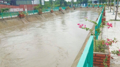
Specifically, the total rainfall from 7:00 AM on December 9th to 7:00 AM on December 10th was generally between 20 and 50mm, with some areas exceeding 50mm, such as Tu Bong (59.4mm) and Khanh Thuong (56.6mm). Forecasts indicate moderate to heavy rain, with some areas experiencing very heavy rain and thunderstorms, from December 10th to the morning of December 11th in Khanh Hoa province. Total rainfall is expected to range from 40 to 80mm per period, with some areas exceeding 150mm per period. During thunderstorms, there is a possibility of tornadoes, lightning, and strong gusts of wind. A warning is issued regarding the risk of heavy rainfall (over 50mm/3 hours).
Rainfall amounts at some locations are forecast as follows: Communes and wards: Van Ninh, Dai Lan, Dong Ninh Hoa, Tay Ninh Hoa, Khanh Vinh, Tay Khanh Vinh, Dien Khanh, Nha Trang, Thuan Nam: 30-70mm/period, with some areas exceeding 80mm/period; Communes and wards: Khanh Son, Tay Khanh Son, Bac Ai, Ninh Son, Phan Rang, Cam Ranh, Cam Lam, Ninh Hai, Thuan Bac, Ninh Phuoc: 40-80mm/period, with some areas exceeding 150mm/period.
On the afternoon and night of December 11th and 12th, Khanh Hoa province will experience showers and scattered thunderstorms. During thunderstorms, be wary of tornadoes, lightning, and strong gusts of wind.
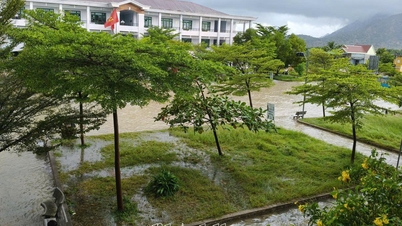
Authorities warn that heavy rains are likely to cause flooding in low-lying areas, and there is a risk of landslides in areas with steep terrain and weak geological foundations. In addition, thunderstorms accompanied by tornadoes, lightning, and strong winds can cause roof damage, tree breakage, and injuries to people and livestock.
 |
| Map predicts total rainfall over the next 24 hours. |
Regarding flood warnings on rivers, over the past 24 hours, water levels on rivers in Khanh Hoa province have fluctuated slightly. At 9:00 AM on December 10th, water levels at the following stations were: On the Cai Nha Trang River, at the Dong Trang hydrological station, the water level was 3.76m, 4.24m below alarm level 1; at the Dien Phu station, it was 2.64m, 1.86m below alarm level 1. On the Cai Phan Rang River, at the Tan My hydrological station, the water level was 33.44m , 2.06m below alarm level 1; at the Phan Rang station, the water level was 0.12m , 2.38m below alarm level 1. On the Dinh Ninh Hoa River, at the Duc My station, the water level was 14.03m, 1.47m below alarm level 1; at the Ninh Hoa hydrological station, the water level was 3.03m, 1.17m below alarm level 1.
Warning: In the next 24 hours, there is a possibility of a flood on the rivers of Khanh Hoa province, with the flood peak at alert level 1-2. It is necessary to be on guard against the risk of flash floods and landslides in mountainous areas. Rain and floods affect the safety of reservoirs; inundate low-lying areas, riverside areas, and urban areas in Khanh Hoa province. Floods can have a negative impact on the environment, threaten people's lives; cause local traffic congestion, and affect the movement of vehicles.
C.D
Source: https://baokhanhhoa.vn/xa-hoi/202512/du-bao-mua-lon-va-canh-bao-lu-tren-cac-song-9404ff5/


![[Photo] Explore the US Navy's USS Robert Smalls warship](/_next/image?url=https%3A%2F%2Fvphoto.vietnam.vn%2Fthumb%2F1200x675%2Fvietnam%2Fresource%2FIMAGE%2F2025%2F12%2F10%2F1765341533272_11212121-8303-jpg.webp&w=3840&q=75)

![[Photo] The captivating scenery of the fragrant maple forest in Quang Tri](/_next/image?url=https%3A%2F%2Fvphoto.vietnam.vn%2Fthumb%2F1200x675%2Fvietnam%2Fresource%2FIMAGE%2F2025%2F12%2F10%2F1765353233198_lan09046-jpg.webp&w=3840&q=75)


![[Video] The craft of making Dong Ho folk paintings has been inscribed by UNESCO on the List of Crafts in Need of Urgent Safeguarding.](https://vphoto.vietnam.vn/thumb/402x226/vietnam/resource/IMAGE/2025/12/10/1765350246533_tranh-dong-ho-734-jpg.webp)


Comment (0)