
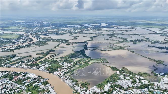
According to the An Giang Province Hydrometeorological Station, in the past 24 hours, the water level in the upstream areas of the Tien and Hau rivers in An Giang has been slowly decreasing, while the downstream areas have been rising rapidly following the tide. By the end of October 2, the highest water level on the Hau River in Long Xuyen was recorded at 248 cm, 2 cm below alert level 3.
The highest water level on November 2 at Tan Chau station on Tien River was 318 cm, 32 cm below alarm level 1; at Chau Doc station on Hau River was 299 cm, 1 cm below alarm level 1; at Long Xuyen station on Hau River was 248 cm, 2 cm below alarm level 3; at Can Tho station on Hau River was 193 cm, 3 cm above alarm level 2 and at My Thuan station on Tien River was 186 cm, 6 cm above alarm level 2.
Due to the influence of the high tide on the 15th day of the 9th lunar month, the water level on the Hau River at Khanh An changed slowly. On rivers, canals and streams in the Long Xuyen Quadrangle, the water level continued to fall slowly. By November 7, the highest water level on the Hau River at Khanh An was at alert level 1 and approximately alert level 2.
In the next 3 - 5 days, on Vinh Te, Tri Ton, Ba The, Vinh Tre, Nui Choc, Nang Gu, Mac Can Dung, Rach Gia - Long Xuyen, Cai San canals, An Giang province, the water level will still be high, at about 15 cm above alert level 1 to alert level 2.
Due to the rising water level following the full moon tide of the ninth lunar month, the An Giang Provincial Hydrometeorological Station warns: The peak tide of the Hau River in Long Xuyen Ward, An Giang Province this time is likely to be above alert level 3 by 10-20 cm. The time of occurrence is from November 6-8 (ie September 17-19 of the lunar calendar). The highest water level on the Hau River at Long Xuyen Station (An Giang Province) on November 3 is forecast to be 256 cm, on November 4 it will be 261 cm and the highest water level on November 5 will be 264 cm.
Due to the influence of the peak tide, rising water levels are likely to cause flooding and localized inundation in low-lying areas, riverside areas, canals, ditches, and key culverts in Long Xuyen, Binh Duc, My Thoi wards and My Hoa Hung commune, An Giang province. Among them, in Long Xuyen ward, there is a possibility of flooding and inundation in the embankment area along the Hau River, Rach Gia Long Xuyen canal; My Thoi ward is flooded in the area of Hoi Dong canals, Goi Be canal, Cai Sao-Bo Ho and low-lying areas along the Hau River through My Hoa Hung commune.
Flooding time in the morning is from 3:30 am to 5:30 am; in the evening is from 3:30 pm to 5:00 pm. The maximum flood depth is from 5-30 cm. The flood disaster risk warning level is level 2.
The An Giang Province Hydrometeorological Station also warned of the peak tide on November 6-8 in the Hau River area in Long Xuyen Ward due to its large width, deep river, strong flow speed and large, deep flooded area. Therefore, when strong winds occur, they can create large waves causing erosion and landslides on river banks, canals and streams. Therefore, the locality needs to be on guard against the possibility of landslides on embankments, weak dykes and traffic routes in flooded areas.
Source: https://baotintuc.vn/xa-hoi/du-bao-vung-ha-luu-song-hau-tai-an-giang-dinh-trieu-tren-bao-dong-3-20251103190358691.htm
![[Photo] The road connecting Dong Nai with Ho Chi Minh City is still unfinished after 5 years of construction.](https://vphoto.vietnam.vn/thumb/1200x675/vietnam/resource/IMAGE/2025/11/04/1762241675985_ndo_br_dji-20251104104418-0635-d-resize-1295-jpg.webp)

![[Photo] Panorama of the Patriotic Emulation Congress of Nhan Dan Newspaper for the period 2025-2030](https://vphoto.vietnam.vn/thumb/1200x675/vietnam/resource/IMAGE/2025/11/04/1762252775462_ndo_br_dhthiduayeuncbaond-6125-jpg.webp)
![[Photo] Ho Chi Minh City Youth Take Action for a Cleaner Environment](https://vphoto.vietnam.vn/thumb/1200x675/vietnam/resource/IMAGE/2025/11/04/1762233574890_550816358-1108586934787014-6430522970717297480-n-1-jpg.webp)

![[Photo] Ca Mau "struggling" to cope with the highest tide of the year, forecast to exceed alert level 3](https://vphoto.vietnam.vn/thumb/1200x675/vietnam/resource/IMAGE/2025/11/04/1762235371445_ndo_br_trieu-cuong-2-6486-jpg.webp)


Comment (0)