
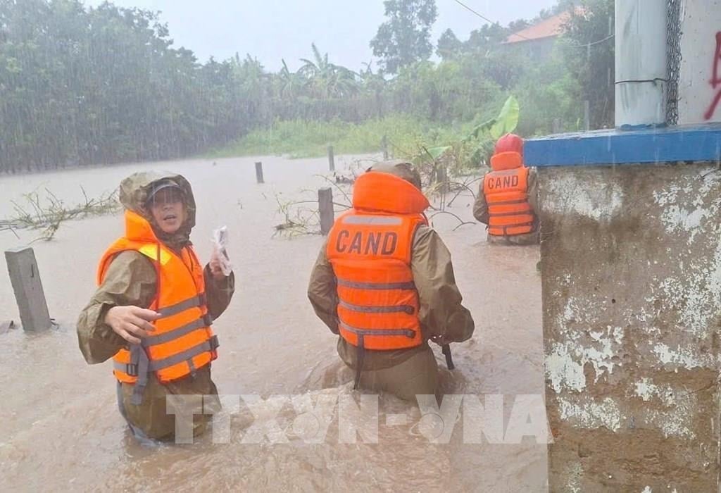
Authorities in communes and wards have urgently evacuated many households to safety. Meanwhile, authorities warn of a high risk of flooding tomorrow in many downstream areas of the rivers.
On the afternoon of October 18, Mr. Nguyen Quoc Thang, Chairman of the People's Committee of Binh Kien Ward ( Dak Lak Province) said that due to heavy rain that lasted throughout the day, many areas in the villages of Thuong Phu, Phu Quang, Phu An, Cam Tu, Son Tho, Xuan Hoa, Phan Quang... were flooded more than 0.5 meters deep. The ward's functional forces were present at the routes in the above villages to put up warning ropes, prohibiting people from moving back and forth to ensure the safety of life and property.
Meanwhile, Chairman of the People's Committee of Duc Binh Commune (Dak Lak Province) Nguyen Ba Quang said that National Highway 29 through the area continued to be cut off by rising floodwaters for a 200m section, making it impossible for vehicles to pass. Authorities were present at this location to warn and regulate traffic. Some other sections of National Highway 29 through the area were also partially flooded, making it difficult for people and vehicles to move. In Yang Mao Commune (Dak Lak Province), heavy rain continued on November 18, causing landslides in 7 mountainous locations and roads in the commune. Notably, in Ea Han village, a total of 200 households were cut off and isolated due to prolonged heavy rain causing flooding.
Mr. Nguyen Tan Truc, Chairman of the People's Committee of Yang Mao Commune, said that the local police and militia forces had evacuated many households in the village to a safe place. Currently, some households are still being evacuated by the authorities on the night of November 18. Heavy rains combined with high tides have caused many communes and wards in the northeast of Dak Lak province to be partially flooded.
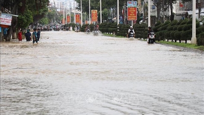
In Xuan Loc commune alone, heavy rain caused 500m of National Highway 1 through the area to be flooded, cutting off traffic for about 0.5 hours on the evening of November 18. In addition, many residential areas in the commune are at risk of deep flooding tonight.
Chairman of Xuan Loc Commune People's Committee Le Dong Quan said that the authorities have evacuated 150 households in flooded areas to safety. Currently, the locality continues to review and evacuate more households on the night of November 18. According to information from the Dak Lak Provincial Hydrometeorological Station, at 4:00 p.m. on November 18, flood levels on the rivers: Ban Thach, Ky Lo, Tam Giang, the lower reaches of Ba River and the lower reaches of Sre Pok River are rising rapidly. It is forecasted that in the next 6-12 hours, floods on Ban Thach and Ky Lo rivers will continue to rise, the flood peak at Cung Son station will reach alert level 2 - 3, Hoa My Tay station will reach alert level 3, and Da Loc station will reach approximately alert level 3. On the Sre Pok River basin, water levels will continue to rise; at Ban Don station they will reach approximately alert level 2, and at Giang Son station they will fluctuate slowly at alert level 1 - 2.
Dak Lak Provincial Hydrometeorological Station warns: Floods cause inundation in low-lying areas along rivers and streams; landslides on steep slopes along rivers and streams, residential groups/villages/hamlets in the following communes and wards: Phu Mo, Dong Xuan, Xuan Lanh, Xuan Phuoc, Son Hoa, Song Hinh, Tay Hoa, Phu Hoa, Hoa Thinh, Binh Kien, Ea Ly, Ea Ba, Tay Son, Van Hoa, Duc Binh, Son Thanh, Hoa My, Ea Ba, Suoi Trai, Son Hoa, Son Thanh, Phu Hoa 1, Tay Hoa, Tuy Hoa, Hoa Son, Cu Pui, Vu Bon, Krong Bong, Dang Kang, Ea Ning, Dray Bhăng, Dur Kmal, Dak Lieng, Krong Ana, Ea Na, Hoa Phu, Ea Nuol, Ea Wer, Ea Sup, Ea Rok, La Lop, Ea Bung, Ia Rve.
According to the 11am bulletin of the Central Hydrometeorological Station, on the Ba River basin, from November 18-19, there will be moderate rain, heavy rain, and very heavy rain in some places. The total rainfall in the basin is forecast to be from 100 - 200mm, and in some places in the downstream over 300mm. In the next 24 hours, floods in the upstream Ba River will fluctuate at alert levels 2 - 3. In the midstream, floods will continue to rise rapidly, possibly reaching alert levels 3 to above alert levels 3. In the downstream, water levels will rise again, fluctuating at alert levels 2 - 3. Water flow to Song Ba Ha reservoir will increase again and peak tomorrow night (November 19), with a flood peak of 8,000 - 9,000 m³/s.
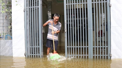
Song Ba Ha Hydropower Joint Stock Company said that at 5:00 p.m. on November 18, the total water flow of Song Ba Ha Hydropower Plant discharged downstream was more than 5,500 m3/s. The company recommends that people in the downstream area from the evening of November 18 to the evening of November 19 move their belongings to higher ground and be careful when moving through low-lying areas and riverside areas to avoid loss of life and property.
According to VNASource: https://baohaiphong.vn/mua-lon-tiep-tuc-gay-ngap-lut-sat-lo-nhieu-noi-tren-dia-ban-tinh-dak-lak-527103.html

![[Photo] General Secretary To Lam receives Slovakian Deputy Prime Minister and Minister of Defense Robert Kalinak](https://vphoto.vietnam.vn/thumb/1200x675/vietnam/resource/IMAGE/2025/11/18/1763467091441_a1-bnd-8261-6981-jpg.webp)


Comment (0)