

On the evening of October 31, Director of Nam Ha Tinh Irrigation Company, Tran Manh Cuong, said: At 5:00 p.m., the water level of Ke Go Lake was at 31.93/32.5m, capacity 328/345 million m 3 , reaching nearly 95% of the design capacity. The amount of water flowing into the lake was 517 m 3 / second. The lake overflowed at a flow rate of 450 m 3 / second.
Due to the large water flow causing the lake water level to rise rapidly, from 5:30 p.m., the unit increased the discharge flow of Ke Go lake from 450 m3 /second to 500 m3 /second.
"Currently, the tide level is going down, increasing the overflow discharge of Ke Go reservoir will both limit the impact on the downstream area and lower the lake water level, increasing flood prevention capacity when heavy rain is forecast to continue to develop complicatedly," said Tran Manh Cuong, Director of Nam Ha Tinh Irrigation Company Limited.
In addition to Ke Go Lake, at this time, Nam Ha Tinh Irrigation Company Limited is also overflowing Song Rac Lake with a flow rate of 452 m3 /second; Kim Son Lake 50 m3 /second, Thuong Song Tri Lake 100 m3 /second; Tau Voi Lake 10 m3 /second, Khe Xai Lake 25 m3 /second; Boc Nguyen Lake 10 m3 /second; Da Han Lake 48 m3 /second.
The water level of Ngan Truoi Lake alone is 44.86/52m, capacity 503.5/775.7 million m3 , reaching 64.9% of design.
Medium and small reservoirs have capacity of 90 - 100% of design capacity.

Meanwhile, at Ho Ho Hydropower Plant at 5:00 p.m. on October 31, the upstream water level was 66.45 m, the downstream water level was 24.3 m; the water flow to the plant's reservoir was 1,090 m3 /second and was overflowing at a flow rate of 1,206 m3 /second.
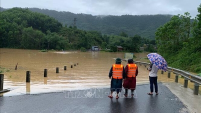
According to the Ha Tinh Hydrometeorological Station, at 5:00 p.m., the water levels at hydrological stations were as follows: On the La River at Linh Cam station 2m (2.5m below alarm level 1); on the Ngan Pho River at Son Diem station 6.76m (3.24m below alarm level 1); on the Ngan Sau River at Chu Le station 11.64m (0.14m above alarm level 1), at Hoa Duyet station 6.56m (0.94m below alarm level 1); Thach Dong station 1.26m; Cam Nhuong station 0.87m.
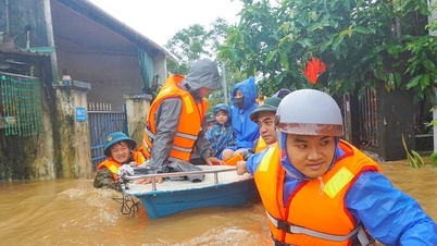
Due to the influence of cold air combined with high altitude easterly winds, from the night of October 29 to October 31, there was rain in Ha Tinh, especially in the southern coastal plains, there was moderate rain, heavy rain, and in some places very heavy rain.
Rainfall measured at automatic rain gauge stations from 5:00 p.m. on October 29 to 11:00 a.m. on October 31 was generally between 300mm and 700mm.
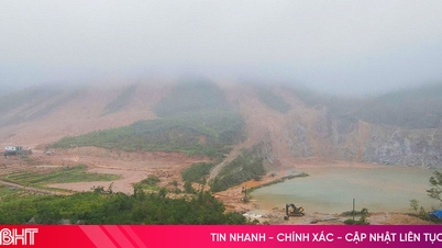
It is forecasted that from the evening of October 31 to the end of November 2, the western mountainous areas and the northern coastal plains will have moderate to heavy rain, with rainfall of 200 - 350mm, with some places over 500mm; the southern coastal plains will have heavy rain, with some places very heavy rain, with rainfall of 200 - 400mm, with some places over 600mm.
Heavy rains have caused rivers in the Ha Tinh region to potentially experience a flood. During this flood, the flood peak on the Ngan Sau and Ngan Pho rivers will be at alert level 2 to alert level 3, some places will be above alert level 3, and the La River will be at alert level 1 to alert level 2.
Source: https://baohatinh.vn/muc-nuoc-trieu-xuong-ho-ke-go-tang-luu-luong-xa-tran-post298522.html
![[Photo] Ca Mau "struggling" to cope with the highest tide of the year, forecast to exceed alert level 3](https://vphoto.vietnam.vn/thumb/1200x675/vietnam/resource/IMAGE/2025/11/04/1762235371445_ndo_br_trieu-cuong-2-6486-jpg.webp)


![[Photo] Panorama of the Patriotic Emulation Congress of Nhan Dan Newspaper for the period 2025-2030](https://vphoto.vietnam.vn/thumb/1200x675/vietnam/resource/IMAGE/2025/11/04/1762252775462_ndo_br_dhthiduayeuncbaond-6125-jpg.webp)
![[Photo] Ho Chi Minh City Youth Take Action for a Cleaner Environment](https://vphoto.vietnam.vn/thumb/1200x675/vietnam/resource/IMAGE/2025/11/04/1762233574890_550816358-1108586934787014-6430522970717297480-n-1-jpg.webp)
![[Photo] The road connecting Dong Nai with Ho Chi Minh City is still unfinished after 5 years of construction.](https://vphoto.vietnam.vn/thumb/1200x675/vietnam/resource/IMAGE/2025/11/04/1762241675985_ndo_br_dji-20251104104418-0635-d-resize-1295-jpg.webp)


Comment (0)