
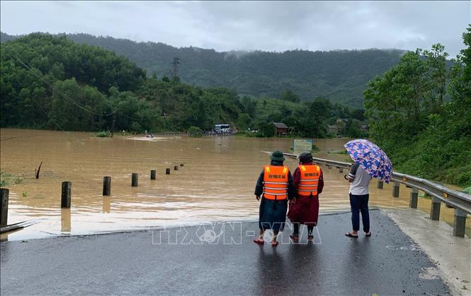
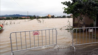
Accordingly, by 6:00 a.m. on November 4, the entire Quang Tri province had 18 flooded locations from 0.2 - 1m at 8 points on national highways and 10 points on provincial roads; concentrated on National Highway 9C, National Highway 12A, Provincial Road 49C, Provincial Road 564B, Provincial Road 559... At flooded roads, local authorities have placed warning signs for people and vehicles not to move through; the Traffic Police have assigned forces to block and direct vehicles to move through non-flooded roads.
In addition, the whole province currently has 51 landslide locations; on national highways there are 5 locations, on provincial roads there are 11 locations, the rest are on inter-commune and inter-village roads; of which, National Highway 9C at Km29+100; Km38+400 (Kim Ngan commune) has a positive slope landslide with a length of 60m, volume of about 3,100 m3; National Highway 9B at Km 77+700 (Kim Ngan commune) has a positive slope landslide with a volume of about 3,500 m3; National Highway 9 at Km48+120-140(P) has a positive slope landslide with a volume of about 200 m3; National Highway 12C at Km75+200 (T) has a cracked road surface, and a negative slope subsidence with a length of about 20 m; National Highway 15, section Km450+00 - Km465+00, asphalt road surface is eroded and damaged in many places.
In particular, on the Ho Chi Minh Highway West branch through Da Chat village (Truong Son commune), a crack about 40m long, 22cm deep, wide gap appeared, of which the widest gap was up to 15cm. In addition, on provincial roads 587, 571, 558... many locations of the road surface were eroded, subsided, and the negative slope and positive slope collapsed; traffic was difficult, posing a potential risk to traffic safety.
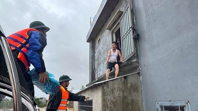
At landslide sites on national and provincial highways, functional units quickly deployed forces and vehicles to the scene to ensure temporary traffic and overcome the consequences. Road management teams coordinated with local authorities to clear rocks and soil, dredge drainage ditches, and temporarily reinforce slopes at risk of further landslides. At the same time, functional sectors directed to increase the installation of warning signs, barriers, and arrange 24/7 guards at key points to ensure safety for people and vehicles.
According to the Quang Tri Province Civil Defense Command, as of 6:00 a.m. on November 4, the entire province had over 164 flooded locations; 51 landslide locations; more than 5,167 households/15,637 people were flooded, of which 198 households/850 people were isolated; 103 locations/28,513 students had to temporarily stop going to school.
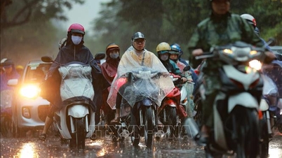
It is forecasted that in the next 6 hours (from 6:00 on November 4 to 12:00 on November 4) in Quang Tri province, rain tends to decrease in volume and area, some areas will have moderate rain. Quang Tri province directs units and localities to regularly update the situation of natural disasters, floods and forecasts to proactively deploy response plans; at the same time, be ready to deploy plans to evacuate people from dangerous areas when situations occur.
Source: https://baotintuc.vn/xa-hoi/quang-tri-tap-trung-khac-phuc-sat-lo-ngap-lut-tren-cac-tuyen-duong-giao-thong-20251104081702452.htm
![[Photo] Opening of the 14th Conference of the 13th Party Central Committee](https://vphoto.vietnam.vn/thumb/1200x675/vietnam/resource/IMAGE/2025/11/05/1762310995216_a5-bnd-5742-5255-jpg.webp)
![[Photo] The road connecting Dong Nai with Ho Chi Minh City is still unfinished after 5 years of construction.](https://vphoto.vietnam.vn/thumb/1200x675/vietnam/resource/IMAGE/2025/11/04/1762241675985_ndo_br_dji-20251104104418-0635-d-resize-1295-jpg.webp)

![[Photo] Panorama of the Patriotic Emulation Congress of Nhan Dan Newspaper for the period 2025-2030](https://vphoto.vietnam.vn/thumb/1200x675/vietnam/resource/IMAGE/2025/11/04/1762252775462_ndo_br_dhthiduayeuncbaond-6125-jpg.webp)


Comment (0)