
Video : Weather forecast for November 17.
According to the National Center for Hydro-Meteorological Forecasting, at 1:00 a.m. on November 17, the center of super typhoon Man-yi was located in the sea east of the central Philippines.
The strongest wind near the storm center is level 16 (184-201km/h), gusting over level 17. The super storm is moving northwest at a speed of 20km/h.
It is forecasted that in the next 24 hours, storm Man-yi will move northwest at a speed of about 20km/h and enter the East Sea, becoming the 9th storm of the year and then gradually weaken.
The eye of the storm is located in the eastern sea of the North East Sea. The strongest wind near the eye of the storm is level 13, gusting to level 15.
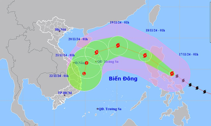
Super typhoon Man-yi moves fast, making landfall in the East Sea in the next 24 hours. (Source: NCHMF)
At around 1am on November 19, the storm arrived in the North East Sea, about 490km northeast of the Hoang Sa archipelago, moving northwest at a speed of 20-25km/h, continuing to weaken. The strongest wind near the storm's center was level 11, gusting to level 13.
At 1am on November 20, the storm in the North East Sea, about 160km north of Hoang Sa archipelago, changed direction to West Northwest, moving about 15km per hour. The strongest wind near the storm center was level 8, gusting to level 10.
From the next 72 to 120 hours, the storm moved to the Southwest, traveling 10km per hour, and continued to weaken.
The meteorological agency said that on the afternoon and night of November 17, the eastern sea area of the North East Sea will have strong winds of level 6-7, then increasing to level 8-9, the area near the storm's eye will have winds of level 11-13, gusting to level 16, the sea will be rough, waves 2-4m high, the area near the storm's eye will be 5-7m.
In addition, from the night of November 17, the eastern sea area of the North East Sea will have storms.
During the day and night of November 18, the North East Sea will have strong winds of level 6-7, gusts of level 8-9, waves of 3-5m high, near the eye of the storm 6-8m, rough seas. In the East, strong winds of level 8-9, near the eye of the storm level 10-12, gusts of level 16.
In the Gulf of Tonkin, the northeast wind gradually increases to level 6, gusting to level 7-8, waves 2-4m high, rough sea.
Mr. Nguyen Van Huong, Head of Weather Forecasting Department, National Center for Hydro-Meteorological Forecasting, said that the time when storm Man-yi moved into the East Sea was also the time when the East Sea was affected by a strong cold air mass.
The interaction of cold air and storm Man-yi will cause many changes in the intensity and direction of storm Man-yi.
The most important thing to note is that the interaction of cold air and storm Man-yi will make the weather in the East Sea region very bad in the coming days, with strong winds, high waves and rough seas. The development of this storm is still changing, so we need to monitor it closely.
Source: https://vtcnews.vn/sieu-bao-man-yi-tien-nhanh-vao-bien-dong-bien-dong-du-doi-ar907828.html


![[Photo] Opening of the 14th Conference of the 13th Party Central Committee](https://vphoto.vietnam.vn/thumb/1200x675/vietnam/resource/IMAGE/2025/11/05/1762310995216_a5-bnd-5742-5255-jpg.webp)


![[Photo] Panorama of the Patriotic Emulation Congress of Nhan Dan Newspaper for the period 2025-2030](https://vphoto.vietnam.vn/thumb/1200x675/vietnam/resource/IMAGE/2025/11/04/1762252775462_ndo_br_dhthiduayeuncbaond-6125-jpg.webp)


Comment (0)