
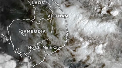
(Chinhphu.vn) – It is forecasted that on September 17, the tropical depression will enter the East Sea and become storm No. 4. The Ministry of Agriculture and Rural Development has issued a dispatch directing proactive response.

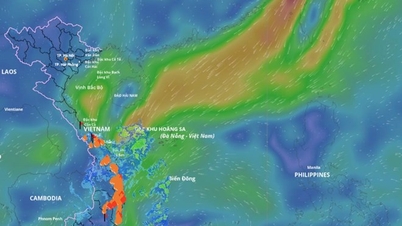
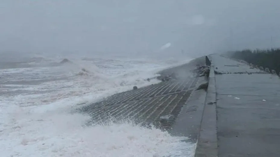
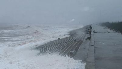
Forecast of location and path of tropical depression (storm no. 4). Photo: NCHMF
The National Center for Hydro-Meteorological Forecasting said: On September 16, a tropical depression is active in the sea east of Luzon Island (Philippines).
At 7:00 a.m. on September 17, the center of the tropical depression was at about 16.9 degrees North latitude; 120.9 degrees East longitude, on the mainland of Luzon Island (Philippines).
The strongest wind near the center of the tropical depression is level 7 (50-61km/h), gusting to level 9 ; moving mainly in the West direction at about 15-20km/h.
Forecast of tropical depression ( in the next 24 to 48 hours)
| Forecast time | Direction, speed | Location | Intensity | Danger zone | Disaster Risk Level (Affected Area) |
| 07:00/18/9 | West Southwest, about 25km/h, moving into the East Sea, strengthening into a storm | 16.5 N-115.0E; in the North East Sea area, about 270km east of Hoang Sa archipelago | Level 8, level 10 | 15.0N-19.0N; East of longitude 113.5E | Level 3: North East Sea area |
| 07:00/19/9 | West, 15-20km/h | 16.5N-111.0E; in the area west of Hoang Sa archipelago | Level 9, level 10 jerk | 15.0N-19.0N; 109.5E-117.0E | Level 3: North East Sea area (including Hoang Sa archipelago area) |
Storm warning ( from next 48 to 72 hours)
In the next 48 to 72 hours, the storm is likely to change direction, moving in a West Northwest direction, traveling about 10km per hour.
Impact forecast
At sea : The eastern sea of the North East Sea has strong winds of level 6-7, the area near the storm center has winds of level 8 (62-74km/h), gusts of level 10 (89-102km/h), rough seas.
Rising water, big waves: In the eastern sea area of the North East Sea, waves are 2.0-4.0m high, increasing to 3.0-5.0m from the afternoon of September 17.
Vessels operating in the above mentioned danger zones are susceptible to strong winds and large waves.
In Huyen Tran, there are strong winds of level 6, gusts of level 8-9; in the western sea area of the South China Sea (including the western sea area of Truong Sa archipelago), there are strong winds of level 6, sometimes level 7; Truong Sa has gusts of level 7.
Currently (September 17), the tropical convergence zone with its axis at about 15-18 degrees North latitude connects with the tropical depression at 01:00 on September 17, located at about 17.0 degrees North latitude, 122.0 degrees East longitude; combined with the strong Southwest monsoon, causing showers and thunderstorms in the eastern sea of the North East Sea, the Central and Southern East Sea (including the sea area of Truong Sa archipelago), the sea area from Binh Thuan to Ca Mau.
Forecast for the next 24 hours:
| Forecast time | Affected sea areas | Strong winds | Wave height | ||
| Wind level (Bophorus level) | Direction | Height (meters) | Direction | ||
| Day and night September 17 | From Ninh Thuan to Ca Mau; the south of the Central East Sea area, the South East Sea area (including the waters of the Truong Sa archipelago) | Level 6, sometimes level 7, gusting to level 8-9. Rough seas. | Southwest | 2.0-5.0 | Southwest |
| From Ca Mau to Kien Giang and the Gulf of Thailand | Level 5, sometimes level 6, gusts level 7-8. Rough sea. | Southwest | 2.0-3.0m | Southwest | |
| East of the North East Sea area | Level 6-7, near the storm center level 8, gust level 10. Rough seas. | Multi-directional | 2.0-5.0 | Multi-directional | |
In addition, during the day and night of September 17, in the Gulf of Tonkin, the sea area from Quang Tri to Ca Mau, Ca Mau to Kien Giang, the Gulf of Thailand, the North, Central and South East Sea (including the sea area of Hoang Sa and Truong Sa archipelagos) there will be showers and thunderstorms. During the thunderstorms, there is a possibility of tornadoes and strong gusts of wind of level 7-8.
Currently, the tide level in the western coastal area of the South is high, it is necessary to guard against abnormal water level rise causing sea dike erosion.
Warning, day and night 9/18:
– The North East Sea area (including the Hoang Sa archipelago) has strong winds of level 6-7, near the storm center there are strong winds of level 8, gusting to level 10; rough seas; waves 3.0-5.0m high.
– The sea area north of the Central East Sea has strong winds of level 6-7, gusts of level 8-9; rough seas; waves 3.0-5.0m high.
– The sea area from Ninh Thuan to Ca Mau, the sea area south of the Central East Sea area and the South East Sea area (including the sea area of Truong Sa archipelago) has strong southwest wind level 6, sometimes level 7, gusting to level 8-9; rough sea; waves 2.0-5.0m high.
– The sea area from Ca Mau to Kien Giang and the Gulf of Thailand has southwest wind level 5, sometimes level 6, gusting to level 7-8; rough sea; waves from 2.0-3.0m high.
Disaster risk level due to strong winds at sea: level 2.
Impact Forecast: All vessels operating in the above areas are at high risk of being affected by cyclones, strong winds and large waves.
From the night of September 20-23, there is a possibility of widespread heavy rain.
Weather forecast from the night of September 18 to September 26 (weather change from 3-10 days):
– Northern and North Central regions: from the night of September 20-23, there is a possibility of widespread heavy rain.
– Central and South Central regions: scattered showers and thunderstorms (rain concentrated in the late afternoon and night).
– Central Highlands and Southern regions: moderate rain, heavy rain and thunderstorms, locally very heavy rain until around September 19; then there will be scattered showers and thunderstorms, locally heavy rain (rain is concentrated in the afternoon and night).
Thunderstorms may produce tornadoes, lightning and strong gusts of wind.
Potential impact on the environment, living conditions, infrastructure, socio-economic activities
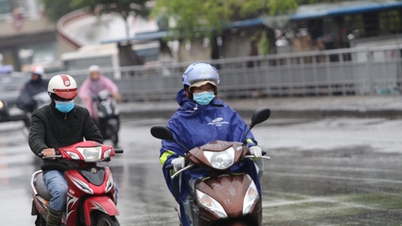
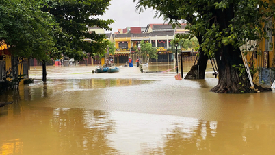
– Heavy rain and localized heavy rain pose a risk of flash floods, landslides in mountainous areas and flooding in low-lying areas. Beware of heavy rain in a short period of time causing flooding in urban areas.
– Thunderstorms accompanied by tornadoes, lightning and strong gusts of wind can affect agricultural production, cause trees to fall, damage houses, traffic works and infrastructure.
Tropical depression strengthens into storm No. 4 with 2 landfall scenarios
Commenting on the development of the tropical depression near the East Sea on VNA, Head of the Weather Forecast Department, National Center for Hydro-Meteorological Forecasting Nguyen Van Huong said that around the morning of September 17, the tropical depression entered the East Sea and on September 18 strengthened into a storm (storm No. 4) with strong winds of level 8 when moving to the central waters of the East Sea (Hoang Sa area).
For storm number 4, there are two possible scenarios.
Scenario 1: The storm is likely to move towards the Central Central region. If this scenario occurs, the storm's impact on the above area may be 1-2 days earlier (around September 19-20).
Scenario 2: The storm changes direction and moves northwest toward the Northern and North Central regions. If this scenario plays out, the storm will impact the mainland by the end of this week.
Referring to the notes for this storm, Mr. Nguyen Van Huong said, in the immediate future, it is necessary to pay attention to the possibility of strong winds and large waves in the eastern area of the northern part of the East Sea (east of longitude 114; north of latitude 14).
Accordingly, from the morning of September 17, the eastern sea area of the North East Sea will have showers, strong thunderstorms, strong winds of level 7 (50-61km/h), gusts of level 9 (75-88km/h), and rough seas.
Vessels operating in the above mentioned danger zones are susceptible to strong winds and large waves.
Regarding the impact of the storm on land, the National Center for Hydro-Meteorological Forecasting will continue to monitor the storm's impact because it is likely that the storm will change after entering the East Sea.
Is storm number 4 as strong as super typhoon YAGI – storm number 3?
According to Mr. Nguyen Van Huong, the current tropical depression is quite similar to super typhoon YAGI - storm number 3 (both in the eastern region of Luzon island - Philippines).
However, the current environmental conditions are not as favorable as storm No. 3 (YAGI) but it has to share moisture with storm Pulasan (active in the Northwest Pacific), so when entering the East Sea, the tropical depression does not immediately strengthen into a storm but takes about 1-2 days to complete its structure to develop into a storm.
In addition to interacting with storm Pulasan (active in the Northwest Pacific); when entering the East Sea, the large-scale flow field from the subtropical high pressure is also fluctuating a lot.
In addition, around September 19, there is also the possibility of a light cold air mass moving down from the North. All current and future atmospheric conditions will make the path of the tropical depression, which will later become a storm, much more complicated than super typhoon YAGI.
“All current Vietnamese and international forecast models agree that the intensity of this storm will not be as strong as storm YAGI,” Mr. Nguyen Van Huong emphasized.
Closely monitor and proactively respond to tropical depressions
According to VNA, on September 16, the Ministry of Agriculture and Rural Development issued Official Dispatch No. 6851/CD-BNN-DD to the People's Committees of coastal provinces and cities from Quang Ninh to Binh Thuan; the Ministries of National Defense, Public Security, Natural Resources and Environment, Transport, Industry and Trade, Information and Communications, and Foreign Affairs; Vietnam News Agency, Vietnam Television, and Voice of Vietnam to closely monitor and proactively respond to the tropical depression.
Specifically, to proactively respond to the developments of the tropical depression, the Minister of Agriculture and Rural Development requested ministries, branches, and Chairmen of People's Committees of coastal provinces and cities from Quang Ninh to Binh Thuan to closely monitor the developments of the tropical depression.
Closely manage vehicles going out to sea; organize counting and notify owners of vehicles and captains of ships and boats operating at sea of the location, direction of movement and developments of tropical depressions so that they can proactively avoid, escape or not move into dangerous areas.
Ministries, branches and localities must be ready with forces and means for rescue when requested, and must organize serious on-duty shifts and regularly report to the Ministry of Agriculture and Rural Development (through the Department of Dyke Management and Disaster Prevention and Control).
The coastal information station system and mass media agencies from central to local levels have increased measures to inform authorities at all levels, owners of vessels operating at sea and people about the developments of tropical depressions so that they can proactively prevent and respond.
At the end of September, 1-2 storms will appear in the East Sea; warning of heavy rain and floods in the Central region
Regarding the weather forecast for the coming time, the National Center for Hydro-Meteorological Forecasting said that the weather in the North in the next 7 days will be mainly little rain, with intermittent sunny days.
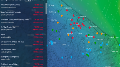
From now until the end of September 17, the Northern region, focusing on Lao Cai, Yen Bai, Phu Tho, Quang Ninh and Hai Phong provinces, will have moderate rain, with common rainfall of 10-30mm/day, and locally heavy rain of over 50mm/day.
From now until the end of September, there is a possibility of 1-2 storms appearing in the East Sea (likely concentrated in the last 10 days of September) and they may affect the Northern and North Central regions.
Warning of high risk of heavy rain and floods in the Central region during the flood season of October-November 2024.
Chinhphu.vn
Source: https://xaydungchinhsach.chinhphu.vn/tin-ap-thap-nhiet-doi-119240916115814904.htm
![[Photo] Party Committees of Central Party agencies summarize the implementation of Resolution No. 18-NQ/TW and the direction of the Party Congress](https://vphoto.vietnam.vn/thumb/1200x675/vietnam/resource/IMAGE/2025/10/27/1761545645968_ndo_br_1-jpg.webp)
![[Photo] National Assembly Chairman Tran Thanh Man receives Chairman of the House of Representatives of Uzbekistan Nuriddin Ismoilov](https://vphoto.vietnam.vn/thumb/1200x675/vietnam/resource/IMAGE/2025/10/27/1761542647910_bnd-2610-jpg.webp)


Comment (0)