
 |
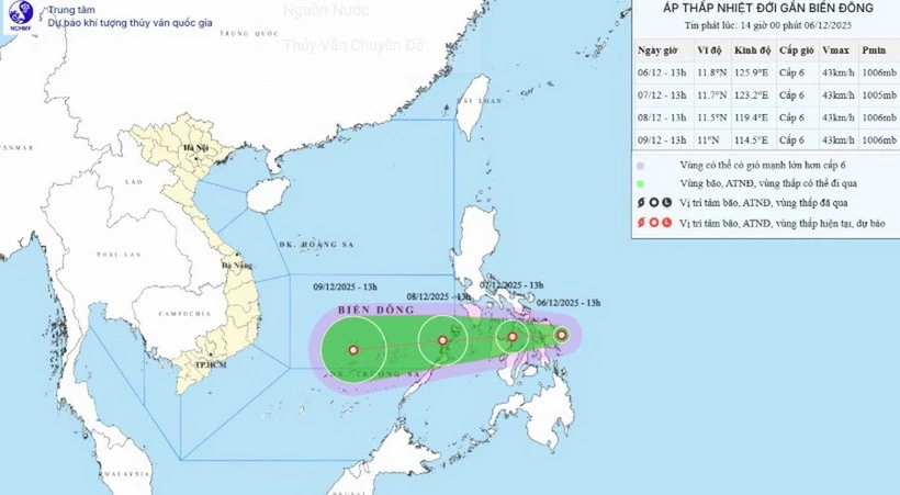
| Image of location and path of tropical depression. (Source: National Center for Hydro-Meteorological Forecasting) |
According to the National Center for Hydro-Meteorological Forecasting, at 1:00 p.m., the center of the tropical depression was at about 11.8 degrees North latitude and 125.9 degrees East longitude.
The strongest wind near the center of the tropical depression is level 6 (39-49 km/h), gusting to level 8. Moving west at a speed of 5-10 km/h.
It is forecasted that by 1 p.m. on December 7, the tropical depression in the central Philippines will move west-southwest at a speed of 10-15 km/h. The strongest wind is level 6, gusting to level 8.
At 1 p.m. on December 8, the tropical depression in the eastern sea area of the central East Sea was moving west-southwest at a speed of 15-20 km/h. The strongest wind was level 6, gusting to level 8.
The affected area is the sea area east of the central East Sea, disaster risk level 3. From the next 48 to 72 hours, the tropical depression continues to move in the West Southwest direction, traveling 20-25km per hour, with little change in intensity.
Due to the influence of a tropical depression, from early morning on December 8, the eastern sea area in the central East Sea has gradually increased winds to level 6, gusts to level 8, waves 2-4m high, and rough seas.
Vessels operating in the above mentioned danger zones are susceptible to the effects of storms, whirlwinds, strong winds and large waves.
According to VNA/Vietnam+
Source: https://baoquangtri.vn/xa-hoi/202512/xuat-hien-ap-thap-nhiet-doi-gan-bien-dong-suc-gio-manh-nhat-cap-6-3543224/

![[Photo] 60th Anniversary of the Founding of the Vietnam Association of Photographic Artists](/_next/image?url=https%3A%2F%2Fvphoto.vietnam.vn%2Fthumb%2F1200x675%2Fvietnam%2Fresource%2FIMAGE%2F2025%2F12%2F05%2F1764935864512_a1-bnd-0841-9740-jpg.webp&w=3840&q=75)
![[Photo] National Assembly Chairman Tran Thanh Man attends the VinFuture 2025 Award Ceremony](/_next/image?url=https%3A%2F%2Fvphoto.vietnam.vn%2Fthumb%2F1200x675%2Fvietnam%2Fresource%2FIMAGE%2F2025%2F12%2F05%2F1764951162416_2628509768338816493-6995-jpg.webp&w=3840&q=75)


Comment (0)