

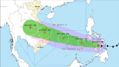
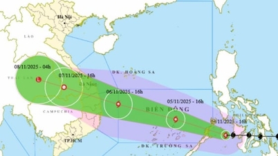
At 7:00 a.m. on November 4, the storm in the central Philippines with strong winds of level 12, gusts of level 15, moved mainly west at a speed of about 20 km/h and had the potential to strengthen.
Then, at 7:00 a.m. on November 5, the storm in the eastern sea area of the central East Sea with strong winds of level 13, gusts of level 15, moving mainly in the West Northwest direction at a speed of about 20-25 km/h, moving into the East Sea and likely to strengthen. The affected area is the eastern sea area of the central East Sea. Disaster risk level 3.
Next, at 7:00 a.m. on November 6, the storm was in the middle of the East Sea, about 430 km east-southeast of the coast of Gia Lai province with strong winds of level 14, gusts of level 17, moving in the West-Northwest direction at a speed of about 20 km/h and likely to strengthen. The affected area is the middle of the East Sea (including Truong Sa special zone). Natural disaster risk level 3.
From the next 72 to 120 hours, the storm will move mainly in the West Northwest direction, about 20km per hour, with stable intensity, then gradually weakening.
Due to the impact of the storm, from around the afternoon of November 4, the sea area east of the central East Sea will have winds gradually increasing to level 6-7, then increasing to level 8-9; the area near the storm center will have strong winds of level 10-12, gusting to level 14-15, waves 5-7m high, and rough seas.
Warning: Around November 5-6, the Central East Sea area (including Truong Sa special zone), the sea area off the coast of Da Nang - Khanh Hoa is likely to be affected by strong winds of level 12-14, gusts above level 17, waves 8-10m high, and rough seas.
All ships and structures operating in the above-mentioned dangerous area are strongly affected by storms, whirlwinds, strong winds and big waves.
Source: https://baotintuc.vn/xa-hoi/bao-kalmaegi-doi-huong-va-co-kha-nang-manh-len-20251103084618232.htm
![[Photo] The road connecting Dong Nai with Ho Chi Minh City is still unfinished after 5 years of construction.](https://vphoto.vietnam.vn/thumb/1200x675/vietnam/resource/IMAGE/2025/11/04/1762241675985_ndo_br_dji-20251104104418-0635-d-resize-1295-jpg.webp)

![[Photo] Panorama of the Patriotic Emulation Congress of Nhan Dan Newspaper for the period 2025-2030](https://vphoto.vietnam.vn/thumb/1200x675/vietnam/resource/IMAGE/2025/11/04/1762252775462_ndo_br_dhthiduayeuncbaond-6125-jpg.webp)
![[Photo] Ca Mau "struggling" to cope with the highest tide of the year, forecast to exceed alert level 3](https://vphoto.vietnam.vn/thumb/1200x675/vietnam/resource/IMAGE/2025/11/04/1762235371445_ndo_br_trieu-cuong-2-6486-jpg.webp)

![[Photo] Ho Chi Minh City Youth Take Action for a Cleaner Environment](https://vphoto.vietnam.vn/thumb/1200x675/vietnam/resource/IMAGE/2025/11/04/1762233574890_550816358-1108586934787014-6430522970717297480-n-1-jpg.webp)


Comment (0)