

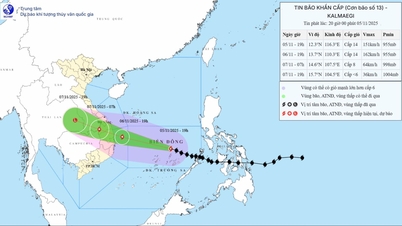
The strongest wind near the storm center is level 13, gusting to level 16.
Accordingly, at 1:00 a.m. on November 4, the center of the storm was at about 10.6 degrees North latitude; 124.6 degrees East longitude, in the central region of the Philippines. The strongest wind near the center of the storm was level 13 (134-149 km/h), gusting to level 16. Moving west at a fast speed of about 25 km/h.
At 1:00 a.m. on November 5, the storm was in the western part of the central Philippines with strong winds of level 12-13, gusting to level 16, moving mainly in the West Northwest direction at a speed of about 25 km/h. The affected area is the sea area east of the central part of the East Sea. Disaster risk level 3.
Forecast until 1:00 a.m. on November 6, the storm is in the middle of the East Sea, about 630 km east-southeast of the coast of Gia Lai province with strong winds of level 14, gusts of level 17, moving mainly in the West-Northwest direction at a speed of about 25 km/h, moving into the East Sea. The affected area is the middle of the East Sea (including Truong Sa special zone). Natural disaster risk level 3.
Next, at 1:00 a.m. on November 7, the storm in the coastal waters from Quang Ngai - Dak Lak with strong winds of level 13, gusts of level 16, moving in the West Northwest direction at a speed of about 25 km/h. The affected area is the area in the middle of the East Sea (including Truong Sa special zone), the sea area from Da Nang to Khanh Hoa (including Ly Son special zone). Natural disaster risk level 4.
From the next 72 to 96 hours, the storm will move mainly in the West-Northwest direction, traveling 20-25 km per hour, gradually weakening in intensity.
Due to the impact of the storm, from around the afternoon of November 4, the sea area east of the central East Sea will have winds gradually increasing to level 6-7, then increasing to level 8-9; the area near the storm center will have strong winds of level 11-13, gusting to level 15-16, waves 5-7m high, and rough seas.
Warning: Around November 5-6, the central area of the East Sea (including Truong Sa special zone), the sea off the coast of Da Nang - Khanh Hoa area is likely to be affected by strong winds of level 12-14, gusts above level 17, waves 8-10m high, and rough seas.
All ships and structures operating in the above-mentioned dangerous area are strongly affected by storms, whirlwinds, strong winds and big waves.
Heavy rain from Ha Tinh to Quang Tri
The National Center for Hydro-Meteorological Forecasting said that on the day and night of November 4, Ha Tinh and Quang Tri areas will have heavy rain, locally very heavy rain with common rainfall of 50-110mm, locally over 200m. Warning of the risk of heavy rain over 80mm/3 hours.
In addition, on the day and night of November 4, in Thanh Hoa, Nghe An, from Hue City to Eastern Quang Ngai, the Central Highlands and the South, there will be scattered showers and thunderstorms with rainfall of 15-35mm, locally heavy rain over 70mm. Warning of the risk of heavy rain over 60mm/3 hours.
From November 5 to the morning of November 6, heavy rain in Ha Tinh and Quang Tri areas tends to decrease gradually. The risk level of natural disasters due to heavy rain, tornadoes, lightning, and hail is level 1.
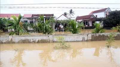
Flood warning on rivers in the Central region
The National Center for Hydro-Meteorological Forecasting forecasts that from 4:30 a.m. to 1:30 p.m. on November 4, floods on the Huong, Bo and Thu Bon rivers will continue to decrease and be at alert level 2 - alert level 3; the Vu Gia river will continue to decrease and be below alert level 2.
In the next 12-24 hours, floods on Huong River and Bo River will continue to fall and be above alert level 2; Vu Gia - Thu Bon River will continue to fall and be at alert level 1 - alert level 2.
From now until November 5, floods on rivers in Ha Tinh and Quang Tri are likely to rise again. During this flood, the peak water level on Ngan Sau and Ngan Pho rivers (Ha Tinh), Gianh, Kien Giang, and Thach Han rivers (Quang Tri) will reach alert level 2-3, with some rivers above alert level 3.
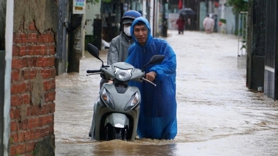
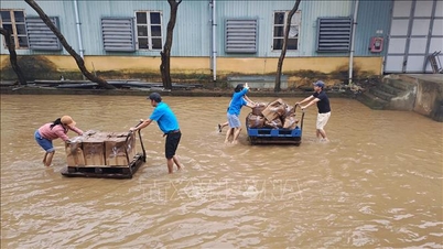
Warning of the risk of flooding in low-lying areas along rivers, urban areas, and densely populated areas in provinces/cities from Ha Tinh to Da Nang. High risk of flash floods on rivers and streams and landslides on slopes in provinces/cities from Ha Tinh to Da Nang (real-time warning information on the risk of flash floods and landslides is provided online on the website of the Department of Hydrometeorology at: https://luquetsatlo.nchmf.gov.vn and in the flash flood and landslide warning bulletin). Level 2 flood disaster risk.
"The forecast and warning information is calculated based on the expected operating level of upstream reservoirs. The hydrometeorological agency will update the bulletins when there are changes in the discharge flow of the reservoirs," emphasized Deputy Head of Hydrological Forecasting Department Nguyen Tien Kien.
Floods on rivers and inundation in low-lying areas affect activities such as water transport, aquaculture, agricultural production, people's lives and socio-economic activities.
Source: https://baotintuc.vn/van-de-quan-tam/bao-kalmaegi-tang-cap-tiep-tuc-huong-ve-khu-vuc-giua-bien-dong-20251104062637339.htm


![[Photo] Opening of the 14th Conference of the 13th Party Central Committee](https://vphoto.vietnam.vn/thumb/1200x675/vietnam/resource/IMAGE/2025/11/05/1762310995216_a5-bnd-5742-5255-jpg.webp)


![[Photo] Panorama of the Patriotic Emulation Congress of Nhan Dan Newspaper for the period 2025-2030](https://vphoto.vietnam.vn/thumb/1200x675/vietnam/resource/IMAGE/2025/11/04/1762252775462_ndo_br_dhthiduayeuncbaond-6125-jpg.webp)


Comment (0)