
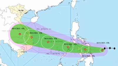
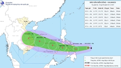
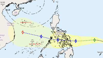
According to the National Center for Hydro-Meteorological Forecasting, last night the tropical depression off the coast of the Philippines strengthened into a storm, with the international name Kalmaegi. At 4 p.m. this afternoon, the center of the storm was in the sea east of the central Philippines with a force of level 9, gusting to level 11.
Due to the very warm sea conditions off the central Philippines (about 30-31 degrees), the storm is very favorable for rapid intensification. The National Center for Hydro-Meteorological Forecasting said that tonight and tomorrow, this storm will begin to enter a rapid intensification cycle, moving steadily westward.
By 4:00 p.m. tomorrow (November 3), while in the sea area off the eastern coast of the central Philippines, the storm will strengthen to level 11-12, gusting to level 15, 2-3 levels higher than today.
During the night of November 3 and the day of November 4, this storm will sweep through the central region of the Philippines with very strong intensity. At 4:00 p.m. on November 4, the center of the storm will be over the western region of the Philippines with a level 12 intensity, gusting to level 15.

It is forecasted that on the night of November 4, the storm will enter the East Sea, becoming the 13th storm of the year. After entering the East Sea, the storm will encounter favorable conditions such as a warm sea surface, weak wind shear and continue to strengthen. It is forecasted that by 4 p.m. on November 5, when operating in the central East Sea area, the storm will strengthen to level 13, gusting to level 16-17.
Worryingly, the storm then moved rapidly west-northwest, about 25km per hour, and continued to strengthen.
The National Center for Hydro-Meteorological Forecasting said that this storm will make landfall directly on the mainland of our country. Landfall may be on the night of November 6 and November 7. The areas most likely to be affected are Da Nang - Quang Ngai.
As of this afternoon, major meteorological stations in the world such as Japan, the US Navy, and Hong Kong also have a high consensus that this is a very strong storm, with a direct landfall in the South Central region of our country, from Da Nang down to the South.
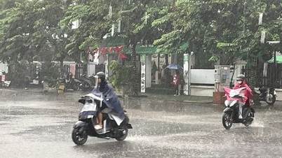
The area where the storm may make landfall is also the area that is experiencing intense heavy rain. Previously, from October 22-30, the area from South Quang Tri to Quang Ngai suffered a record rainstorm, focusing on Hue and Da Nang, record floods appeared on the Bo River and Thu Bon River. From October 31 until now, the Central region has continued to experience widespread heavy rain, stretching from Ha Tinh to Quang Ngai, with the risk of flooding rising again from tonight in Ha Tinh to Da Nang.
Due to the influence of the storm, from the afternoon and night of November 4, the sea area east of the Central East Sea will have winds gradually increasing to level 6-7, then increasing to level 8-9, near the center of the storm will have strong winds of level 10-12, gusting to level 14-15, waves 5-7m high. The sea will be very rough.
During November 5-6, the Central East Sea area (including Truong Sa special zone), the sea area off the coast of Da Nang - Khanh Hoa is likely to be affected by strong winds of level 12-14, gusting to level 17, waves of 8-10m high. The sea will be very rough.

Vietnam is experiencing a fierce storm season with 12 storms active in the East Sea, many of which affect our mainland such as storm No. 1, storm No. 3, storm No. 5, storm No. 10. Of which, storm No. 5 and storm No. 10 made landfall with strong and very strong intensity.
In October alone, there were two storms and tropical depressions active in the East Sea, including storm Matmo, storm Fengshen and a tropical depression. Although it did not cause strong winds on land, the remnants of storm Matmo caused heavy rain and record floods in Thai Nguyen, Bac Ninh and Lang Son.
Meanwhile, the remnants of storm Fengshen combined with other factors such as cold air, easterly wind disturbances, and windward terrain caused the area from South Quang Tri to Quang Ngai to suffer a period of heavy rain from October 22-30, causing record floods in Hue and Da Nang.
Source: https://baolaocai.vn/bao-so-13-cuc-ky-nguy-hiem-tren-bien-dong-post885887.html
![[Photo] General Secretary To Lam receives Singaporean Ambassador Jaya Ratnam](https://vphoto.vietnam.vn/thumb/1200x675/vietnam/resource/IMAGE/2025/11/03/1762171461424_a1-bnd-5309-9100-jpg.webp)


![[Photo] Fall Fair 2025 and impressive records](https://vphoto.vietnam.vn/thumb/1200x675/vietnam/resource/IMAGE/2025/11/03/1762180761230_ndo_br_tk-hcmt-15-jpg.webp)
![[Photo] Prime Minister Pham Minh Chinh receives the Chairman of the Japan-Vietnam Friendship Association in the Kansai region](https://vphoto.vietnam.vn/thumb/1200x675/vietnam/resource/IMAGE/2025/11/03/1762176259003_ndo_br_dsc-9224-jpg.webp)
![[Photo] Lam Dong: Close-up of illegal lake with broken wall](https://vphoto.vietnam.vn/thumb/1200x675/vietnam/resource/IMAGE/2025/11/03/1762166057849_a5018a8dcbd5478b1ec4-jpg.webp)


Comment (0)