
The Southern Hydrometeorological Station forecasts that the cold air will continue to strengthen over the next 3-10 days, then stabilize and gradually weaken. From around December 7-8, the cold air may strengthen again.
From around December 7-9, the tropical depression in the sea east of the central Philippines is likely to enter the East Sea and strengthen into a storm. storm number 16 operating in the East Sea area in 2025.
In November, 3 storms and 1 tropical depression appeared in the East Sea, including storm No. 13 Kalmaegi, which made landfall in Quang Ngai - Gia Lai on the evening of November 6 with a strong intensity of level 12, gusting to level 14; storm No. 14 Fung - Wong (Phuong Hoang) and storm No. 15 Koto, which have just weakened into low pressure areas.
Also this month, an unprecedented tropical depression in meteorological history entered the East Sea on November 29. The tropical depression originated from storm Senyar, moving from the Indian Ocean, through Malaysia to the Northwest Pacific .
According to data from 1951 to present, there have been a number of tropical depressions that have formed at latitudes lower than 5 degrees North (near the equator). However, most of them have moved westward, not eastward. Therefore, it is very rare, if not unprecedented, for a tropical depression to form at low latitudes and move eastward, like the one currently active in the eastern part of Malaysia.
In December, there is a possibility of 1-2 storms or tropical depressions appearing in the East Sea. On average, during the same period in many years, there is 1 storm appearing in the East Sea, and 0.2 storms making landfall in Vietnam.
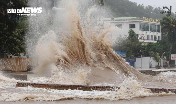
In addition, forecasting heavy rain in the South Central region, the National Center for Hydro-Meteorological Forecasting said that last night and this morning (December 4), South Quang Tri to Da Nang city, the eastern provinces from Quang Ngai to Dak Lak, Khanh Hoa and Lam Dong will have moderate rain, heavy rain, and some areas. very heavy rain and thunderstorms
Rainfall from 7pm on December 3 to 8am on December 4 was over 180mm in some places such as: Ba Na (Da Nang City) 228.2mm; Khanh Hiep (Khanh Hoa) 196mm; Tra Nham (Quang Ngai) 189mm; Phan Dung (Lam Dong) 202.4mm...
On the day and night of December 4, South Quang Tri to Da Nang city and the East of Quang Ngai province continued to receive moderate to heavy rain, with rainfall of 40-80mm, and in some places very heavy rain of over 120mm.
In the East of Gia Lai, Dak Lak, Lam Dong provinces; Khanh Hoa province and the Southeast region, there will be rain, moderate rain, rainfall of 20-40mm, locally heavy rain over 80mm. The Central Highlands and the Southwest region will have scattered showers and thunderstorms, rainfall of 10-30mm, in some places heavy rain over 60mm.
From December 5, heavy rain in the area from South Quang Tri to Da Nang city and the East of Quang Ngai province tends to decrease.
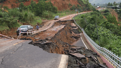
From now until December 5, on rivers from Hue City to Khanh Hoa, there is a possibility of a flood, the flood peak on rivers will reach alarm level 1 and above. In particular, the flood peak on Cai Nha Trang River (Khanh Hoa) will reach level 2-3.
Risk of flooding in low-lying areas along rivers, urban areas, and densely populated areas; risk of flash floods on rivers and streams and landslides on slopes from Hue City to Khanh Hoa.
Source: https://baolangson.vn/bien-dong-kha-nang-sap-don-bao-so-16-5066937.html
![[Photo] Cat Ba - Green island paradise](/_next/image?url=https%3A%2F%2Fvphoto.vietnam.vn%2Fthumb%2F1200x675%2Fvietnam%2Fresource%2FIMAGE%2F2025%2F12%2F04%2F1764821844074_ndo_br_1-dcbthienduongxanh638-jpg.webp&w=3840&q=75)


![[VIMC 40 days of lightning speed] Da Nang Port: Unity - Lightning speed - Breakthrough to the finish line](https://vphoto.vietnam.vn/thumb/402x226/vietnam/resource/IMAGE/2025/12/04/1764833540882_cdn_4-12-25.jpeg)


Comment (0)