
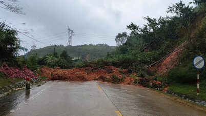
Vietnam is one of the countries that is greatly affected by natural disasters with many extreme and dangerous weather patterns that frequently appear such as storms, tropical depressions, heavy rains, floods, flash floods, landslides, heat waves, droughts, saltwater intrusion, severe cold, etc., causing serious impacts, leading to the lives and properties of the people. To reduce the risks of natural disasters, contributing to socio -economic development, the hydrometeorological sector has been implementing and implementing the construction of an early warning system, applying science and technology in forecasting, contributing to making timely, realistic and highly accurate forecasts and early warnings, responding to all types of natural disasters.
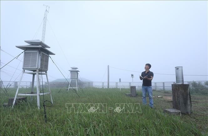 |
| Staff of Mau Son Meteorological Station, Lang Son Province Hydrometeorological Station, observe the weather at the Station. Photo: Anh Tuan/VNA |
Building and applying forecasting and early warning systems
In order for ministries, branches, localities and people to be more proactive in directing, responding to and mitigating damage caused by natural disasters, the hydrometeorological sector has built, deployed and completed a modern and effective forecasting and early warning system. Along with that, the sector has promoted the modernization of the hydrometeorological monitoring station network, including a system of automatic monitoring stations that has been significantly increased in number and prioritized the development of a modern and synchronous automatic hydrometeorological monitoring network.
According to Dr. Hoang Duc Cuong, Deputy Director of the Department of Hydrometeorology ( Ministry of Agriculture and Environment ), in October 2023, the General Department of Hydrometeorology (now the Department of Hydrometeorology) launched the Flood, Storm and Lightning Warning Support System. After 2 years of application, the above system has been effective.
The flood and thunderstorm warning support system consists of 3 main systems and all 3 systems will provide information on analytical maps and quantitative rainfall forecasts for the next 6 hours based on weather radar data and surface rainfall data. This system also integrates warning information on flash floods and landslides caused by rain. All developments in the flood and landslide situation in all regions and territories of Vietnam are continuously monitored and supervised through analytical maps and quantitative rainfall forecasts from 1 to 6 hours. Currently, the 1 to 6 hour rainfall analysis and forecasting system operates stably, with accurate and timely forecast information, effectively serving the work of warning, forecasting hydrometeorology, and providing information that is friendly to the public.
Along with that, forecasting and early warning work has also been done well. For storms and tropical depressions, the forecast has been increased to 3 days, warning 5 days; forecast and warning of heavy rain 2-3 days in advance, warning of thunderstorms from 30 minutes to 2-3 hours in advance. Severe cold spells are warned 5-7 days in advance, forecast 2-3 days in advance. Marine weather forecasting has made great strides thanks to the adoption of new foreign technologies. The resolution for wave forecasting models has been detailed to 4 km and wave forecasts have a forecast period of up to 10 days.
Not only have forecasts been extended, but the timing of the bulletins has also been made earlier. Storm bulletins are now issued 30 minutes to 1 hour earlier than before. Other disaster bulletins such as heat waves, cold fronts, and heavy rains are issued 30 minutes earlier than before.
To effectively carry out forecasting and early warning work, the industry has used Vietnam's CrayXC40 system equipped with 56 computing servers with over 2,100 processors, allowing for a computing capacity of approximately 80TFLOPS and performing weather forecasting at a scale of 2-3 km for the entire territory of Vietnam and the East Sea; forecasting 3 days in 30-40 minutes. With this supercomputer system, the industry has been performing data assimilation, integrating all real-time monitoring systems including: Satellites, radars, surface monitoring, automatic rain gauges; on that basis, making calculations, analyzing and forecasting extreme weather phenomena in the future, from days, weeks to months.
In addition, the meteorological forecast data visualization and editing system (SmartMet) is also used by the industry in the forecasting process. The industry has built a set of tools and programs to calculate the SPI index to serve meteorological drought monitoring, helping to issue bulletins on the scope, intensity, and development of drought nationwide; deploying in operations regional-scale numerical forecasting model systems to enhance the ability to forecast extremes such as heavy rain and strong winds in storms; synchronously and uniformly collect all forecasting systems and combinations from global centers (USA, Japan, Europe). ...
Towards effective solutions
Dr. Hoang Duc Cuong said that the work of forecasting and warning hydrometeorology in general and forecasting and early warning especially for dangerous natural disasters such as storms, tropical depressions, flash floods, landslides, etc. still faces many difficulties. Accordingly, storms and tropical depressions are unpredictable natural disasters with complex developments, rapid changes and depend on many factors, especially the intensity of storms and tropical depressions.
On the other hand, the forecasting skills of forecasting models in Vietnam are currently limited. This is also a common difficulty of hydrometeorological forecasting models. In advanced countries such as Japan, the error in forecasting storm positions 24 hours in advance is currently still at 50 to over 100km). Monitoring data in the East Sea is still difficult, mainly based on satellite observations, while radar data is only effective when storms and tropical depressions are close to shore (about 200km).
In addition, there is a restriction on updating information and data on socio-economic activities at sea and on land, where there is a possibility of being affected by storms and tropical depressions, in order to determine the appropriate level of natural disaster risk in storm and tropical depression bulletins.
Regarding early warning of flash floods and landslides, currently, detailed warning of flash floods and landslides to each residential area and village to minimize human and property damage is still a challenge not only for Vietnam but also for countries with advanced science and technology such as Japan, the US,...
Currently, the world cannot predict flash floods and landslides that will occur at a specific location and at a specific time; it can only warn of the risk of flash floods and landslides in a certain area and within a certain period of time.
For Vietnam, the level of warning details depends on each region. Some provinces have investigated and identified flash flood and landslide hotspots, and the hydrometeorological agency will issue detailed warnings to communes or locations at risk of landslides in the bulletin. For provinces that have not been investigated and assessed in detail, the warnings will be sent to the district level. The provincial and municipal hydrometeorological stations will specify and detail the warnings to communes or locations at risk of landslides.
Vietnam has received the Southeast Asia Flash Flood Warning Support System (SEAFFGS). This is the first flash flood warning support system that uses ultra-short-range forecast data and integrates a large number of different data sources. Vietnam's data has been integrated into the system, including rainfall estimates from 10 radars and more than 1,500 automatic rain stations, Nowcasting rain forecast products, numerical rain forecast products from the WRF model... However, the Southeast Asia Flash Flood Warning Support System cannot yet support forecasting the specific locations of flash floods and landslides, it can only support forecasters in analyzing and warning of rainfall thresholds that cause flash floods for each sub-basin in 1 hour, 3 hours, 6 hours and is updated regularly at corresponding time intervals; landslide risk areas in the next 24 hours with an update frequency of 6 hours/time.
Faced with the above difficulties, along with the assessment of experts in hydrometeorology and natural disaster prevention and control, climate change continues to develop complicatedly, natural disasters in the coming time are forecasted to be unpredictable and extreme... Therefore, the construction and completion of forecasting and early warning systems play a very important role, ensuring the early warning system operates effectively from central to local levels.
Dr. Hoang Duc Cuong stated that, implementing Resolution No. 57-NQ/TW dated December 22, 2024 on breakthroughs in science and technology development, innovation and national digital transformation, the industry has deployed many solutions to improve the capacity to forecast and warn of natural disasters early, such as: Increasing the quantity and quality of meteorological, hydrological and oceanographic monitoring stations, especially in key areas, at sea and areas at high risk of natural disasters in the direction of modernization and automation; enhancing modern monitoring solutions such as weather radar, marine radar, satellite cloud imaging applications, etc.
The industry develops modern forecasting and warning technologies that are close to those of developed countries in hydrometeorology, such as high-resolution digital models for storm forecasting, rain and flood forecasting, flash flood and landslide warnings. Integrate the impacts of climate change on natural disaster developments into hydrometeorological forecasting plans, and continue to research and apply artificial intelligence (AI) in forecasting and warning of natural disasters, first of all for storm forecasting, rain and dangerous weather phenomena that rarely occur according to normal rules. In addition, it is necessary to promote international cooperation in information and data exchange, especially for storms at sea; receive and develop advanced and modern forecasting technologies and processes of countries through bilateral and multilateral cooperation.
The sector continues to coordinate with localities and units under the Ministry of Agriculture and Environment to speed up the implementation of the Project "Early warning of landslides, mudslides, flash floods in the midland and mountainous areas of Vietnam" and the Program to update disaster risk zoning, create disaster warning maps, especially disasters related to storms, storm surges, floods, flash floods, landslides, droughts, and saltwater intrusion.
In the long term, the sector will complete the Plan to implement the National Hydrometeorological Station Network Planning for the period 2021-2030, with a vision to 2050, submit it to the Prime Minister for promulgation and implementation. Along with that, the sector will implement Decision No. 372/QD-BTNMT dated February 16, 2024 of the Minister of Natural Resources and Environment (now the Ministry of Agriculture and Environment) promulgating the Plan to implement Decision No. 1261/QD-TTg dated October 27, 2023 of the Prime Minister approving the Project "Modernization of the Hydrometeorological Sector to 2025 and the period 2026-2030"...
Implementing the above solutions well and effectively will help shorten the gap in forecasting, forecasting, and early warning of natural disasters, helping policymakers focus on minimizing risks and protecting the community. This also helps the community to easily access and proactively take early action to protect the fruits of people's labor and production, towards building a safe and sustainable society against natural disasters.
Source: https://huengaynay.vn/chinh-tri-xa-hoi/hoan-thien-he-thong-du-bao-som-de-giam-thieu-rui-ro-thien-tai-151866.html


![[Photo] National Assembly Chairman Tran Thanh Man received a delegation of the Social Democratic Party of Germany](https://vphoto.vietnam.vn/thumb/1200x675/vietnam/resource/IMAGE/2025/10/28/1761652150406_ndo_br_cover-3345-jpg.webp)
![[Photo] Draft documents of the 14th Party Congress reach people at the Commune Cultural Post Offices](https://vphoto.vietnam.vn/thumb/1200x675/vietnam/resource/IMAGE/2025/10/28/1761642182616_du-thao-tai-tinh-hung-yen-4070-5235-jpg.webp)
![[Photo] Flooding on the right side of the gate, entrance to Hue Citadel](https://vphoto.vietnam.vn/thumb/1200x675/vietnam/resource/IMAGE/2025/10/28/1761660788143_ndo_br_gen-h-z7165069467254-74c71c36d0cb396744b678cec80552f0-2-jpg.webp)


![[Photo] President Luong Cuong attends the 80th Anniversary of the Traditional Day of the Armed Forces of Military Region 3](https://vphoto.vietnam.vn/thumb/1200x675/vietnam/resource/IMAGE/2025/10/28/1761635584312_ndo_br_1-jpg.webp)


Comment (0)