

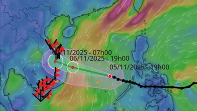
Forecast of location and direction of storm No. 8 (Photo: VNDMS)
According to the National Center for Hydro-Meteorological Forecasting at 4:00 a.m. on September 19, the storm's eye was in the northern sea area of the North East Sea, about 240 km east-southeast of Hong Kong (China). The strongest wind near the storm's eye was level 8-9 (62-88 km/h), gusting to level 11.
Forecast in the next 12 hours, storm number 8 moves northwest at a speed of about 15km/h.
At 4:00 p.m. this afternoon, the storm center was on the southern coastal area of Guangdong province (China), the storm intensity was currently maintained at level 8-9, gusting to level 11.
Mr. Nguyen Van Huong, Head of Weather Forecasting Department, National Center for Hydro-Meteorological Forecasting, said that around this afternoon to tonight (September 19), storm No. 8 will make landfall in Guangdong province (China), then move further inland, weakening into a tropical depression and then a low pressure area.
Due to the influence of the storm, in the northern sea area of the North East Sea, there are strong winds of level 6-7, gusting to level 9. The area near the eye of the storm has strong winds of level 8-9, gusting to level 11, with waves 3-5m high. The sea is very rough.
Vessels operating in the above mentioned dangerous areas are susceptible to the impact of storms, whirlwinds, strong winds and large waves.
"Thus, storm No. 8 is unlikely to affect our mainland. However, the circulation after storm No. 8 is likely to cause widespread thunderstorms in the North from September 23 to 24," said Mr. Huong.
Mr. Huong also said that in addition to storm number 8, there is currently storm Ragasa in the sea east of the Philippines.
It is forecasted that around September 22, the storm will likely move into the East Sea, becoming the ninth storm this year and then directly impact our mainland between September 24 and 26.
"This is a strong storm, capable of causing strong winds and heavy rain in the Northern and Central provinces.
We are continuing to monitor the development of this tropical depression to provide timely forecasts and warnings," Mr. Huong added./.
Today, the South has places with heavy rain over 100mm. It is forecasted that from early morning to afternoon of September 19, the coastal areas of the North will have scattered showers and thunderstorms with rainfall of 10-30mm, with some places having heavy rain of over 60mm. Today and tonight, the area from Thanh Hoa to Da Nang and the South will have scattered showers and thunderstorms with rainfall of 10-30mm, locally heavy to very heavy rain of over 100mm. This afternoon and evening, provinces from Quang Ngai to Lam Dong will have scattered showers and thunderstorms with rainfall of 10-30mm, locally heavy rain over 70mm. Thunderstorms may contain tornadoes, lightning, hail and strong winds. Localized heavy rain is likely to cause flash floods on small rivers and streams, landslides on steep slopes and inundation in low-lying areas. |
According to Tuoi Tre Newspaper
Source: https://tuoitre.vn/hom-nay-bao-so-8-do-bo-trung-quoc-bien-dong-sap-co-con-bao-so-9-20250919061124388.htm
Source: https://baolongan.vn/hom-nay-bao-so-8-do-bo-trung-quoc-bien-dong-sap-co-con-bao-so-9-a202780.html


![[Photo] Da Nang: Hundreds of people join hands to clean up a vital tourist route after storm No. 13](https://vphoto.vietnam.vn/thumb/1200x675/vietnam/resource/IMAGE/2025/11/07/1762491638903_image-3-1353-jpg.webp)


Comment (0)