
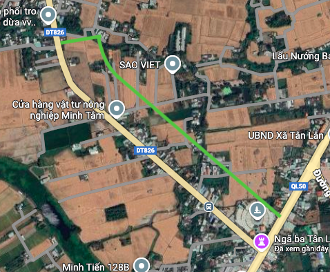
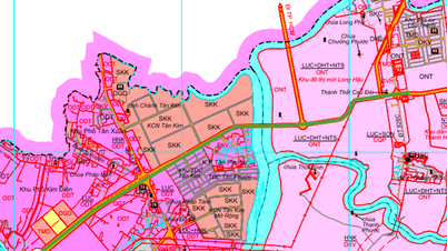
Overview of traffic planning of Tan Lan commune
According to the land use planning adjustment map for the period 2021 - 2030 of Can Duoc district, Long An province, Tan Lan commune is oriented to develop a number of important traffic routes to strengthen regional connectivity and promote socio-economic development. Tan Lan commune is adjacent to many other communes in the district, creating favorable conditions for the construction of connecting roads.

Details of prominent planned routes
In the coming period, two notable traffic infrastructure projects will be implemented in Tan Lan commune, playing a key role in the traffic network of Can Duoc district.
1. Ho Chi Minh City – Soc Trang Expressway (Highway 33)
A section of the Ho Chi Minh City – Soc Trang Expressway is planned to pass through Tan Lan Commune. According to the map, this section is about 600 meters long, running through the area near Tinh Quang Pagoda. When completed, this expressway will create a high-speed connection axis, significantly shortening travel time from Long An to Ho Chi Minh City and the Mekong Delta provinces.

2. Parallel route to Provincial Road 826
The plan also identifies a new route running almost parallel to the existing Provincial Road 826. This route has a total length of about 1 km, with the starting point at Provincial Road 826 and the end point connecting to National Highway 50. This project is expected to help reduce the load on Provincial Road 826, streamline traffic more effectively and enhance connectivity between the two main roads, National Highway 50 and Provincial Road 826.
Impact of infrastructure planning
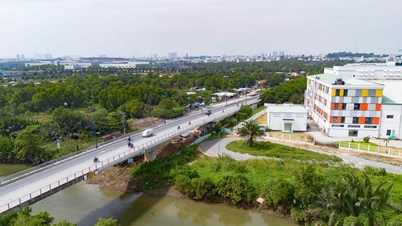
The implementation of new planned routes will open up many development opportunities for Tan Lan commune in particular and Can Duoc district in general. Synchronous transport infrastructure not only facilitates travel and transport of goods but also acts as a driving force to attract investment, promote trade and service activities and can have a positive impact on the real estate market in the area.
Note: Information about the routes in the article is referenced from the Land Use Planning Adjustment Map for the period 2021 - 2030 of Can Duoc district, Long An province. The actual route may change during the implementation process.
Source: https://baolamdong.vn/lo-trinh-cao-toc-va-tuyen-duong-moi-tai-xa-tan-lan-long-an-406706.html

![[Photo] Worshiping the Tuyet Son statue - a nearly 400-year-old treasure at Keo Pagoda](/_next/image?url=https%3A%2F%2Fvphoto.vietnam.vn%2Fthumb%2F1200x675%2Fvietnam%2Fresource%2FIMAGE%2F2025%2F12%2F02%2F1764679323086_ndo_br_tempimageomw0hi-4884-jpg.webp&w=3840&q=75)


![[Photo] Parade to celebrate the 50th anniversary of Laos' National Day](/_next/image?url=https%3A%2F%2Fvphoto.vietnam.vn%2Fthumb%2F1200x675%2Fvietnam%2Fresource%2FIMAGE%2F2025%2F12%2F02%2F1764691918289_ndo_br_0-jpg.webp&w=3840&q=75)


Comment (0)