
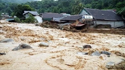
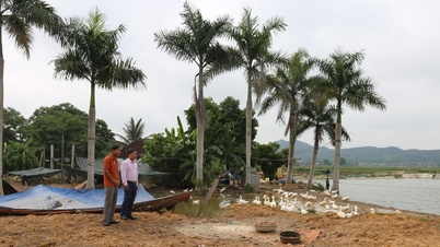
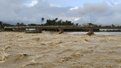
We visited Yen Luong hamlet, Chau Quang commune, and saw several houses precariously situated along the banks of the Nam Huong River, with erosion extending deep into the front yards. Mr. Lu Van Ly, a resident of Yen Luong hamlet, said: "The 2022 flood swept away our pigsties and cow sheds into the Nam Huong River. The recent flood, just over a month ago, has eroded right up to the kitchen area. At this rate, the river will completely engulf our houses in a short time."

An elderly resident of Yen Luong hamlet shared: "I've never seen the river erode so severely before. This year alone, after heavy rains, the river's water turned a muddy red and surged, causing increasingly strong erosion that threatens people's homes. In this area, erosion means losing land; we've never seen the river deposit even a single meter of sediment."
Walking along the Nam Huong River, we saw that the riverbanks were encroaching on acacia hills, and even the sugarcane fields of the local people were being washed away. Mr. Tran Minh, a resident of Chau Quang commune, led us to a sugarcane field that was being eroded, sadly saying: "The sugarcane was almost ready for harvest, but many areas are now submerged in the river. People have lost both their land and their income. We only hope that the authorities will soon take measures to remedy the situation and ensure the safety of people's lives and property."
Investigations have revealed that the majority of people living in landslide-prone areas are still living in poverty. Many households have lost their agricultural land and residential land to the river, forcing them to work as stone or tin laborers, further exacerbating their hardship.
")
Mr. Pham Cong Truyen, Chairman of the Chau Quang Commune People's Committee, added: The Nam Huong River originates from the Chau Thanh and Chau Hong communes and flows into the Dinh River, passing through the commune for more than 3 km. Recent floods have caused riverbank erosion along more than 1 km, affecting 30 households in Yen Luong hamlet. Due to the erosion of the Nam Huong riverbank, over 8 hectares of cultivated land and alluvial land have been washed into the river.
To cope with the landslides, over the years, the People's Committee of the commune has mobilized the people to plant bamboo, drive bamboo stakes, and temporarily reinforce some severely eroded areas with stones, but it has been ineffective; every flood season everything is washed away into the river.
The commune has reported the landslide situation to higher authorities, and the district has also come to assess the situation, but so far no concrete measures have been taken. The commune can only advise residents to be self-aware and protect their lives and property.
")
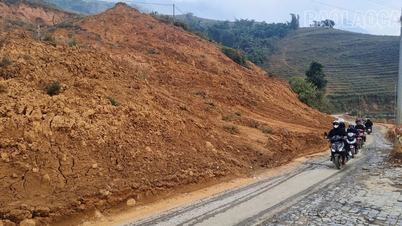
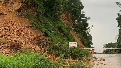
Further downstream is Tam Hop commune, which has also been severely affected by landslides over the years. A representative from the Tam Hop Commune People's Committee stated: "The Dinh River section passing through the commune has suffered landslides along approximately 2.5 km, affecting 154 households at risk of landslides; of which, over 40 households are located in particularly dangerous areas, mainly in Tan Mung, Dinh, Dong Chao, and Soi Duoi hamlets… In addition to damage to land and property of the local people, the Dinh River has damaged more than 2 km of Provincial Road 532."
Over the years, Tam Hop commune has reported the landslide situation to the District People's Committee, and the District People's Committee has also sent teams to inspect and survey the area. However, for many years, the relevant authorities have not come up with any solutions to build embankments to prevent landslides.
")
Mr. Nguyen Duy Hung, Head of the Agriculture and Rural Development Department of Quy Hop District, said: The situation of riverbank erosion along the Dinh River, Nam Ton River, and Nam Huong River, passing through Chau Quang, Tho Hop, and Tam Hop communes, has become increasingly complex in recent years, causing significant property damage and affecting the lives of the people. Riverbank erosion has swept away auxiliary structures of houses, resulting in the loss of cultivated land and residential land.
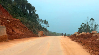
Currently, the entire district has only completed one embankment project in Le village, Chau Quang commune, with a length of approximately 400 meters. To ensure the safety of the people, during the rainy season and storms, the district directs communes to deploy forces to monitor the situation and have plans to relocate households in riverbank erosion areas when necessary.
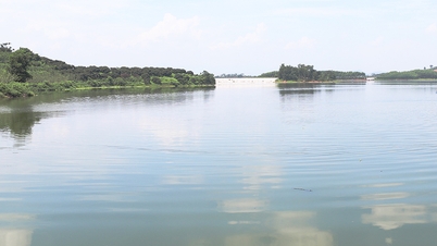
During the rainy season, people in the villages bordering the river in Quy Hop district worry about the floodwaters from upstream. The Nam Huong and Dinh rivers twist and change course. Residential land and cultivated fields of corn, sugarcane, beans, peanuts, etc., are threatened by the raging river.
Source

![[Photo] The captivating scenery of the fragrant maple forest in Quang Tri](/_next/image?url=https%3A%2F%2Fvphoto.vietnam.vn%2Fthumb%2F1200x675%2Fvietnam%2Fresource%2FIMAGE%2F2025%2F12%2F10%2F1765353233198_lan09046-jpg.webp&w=3840&q=75)

![[Photo] Explore the US Navy's USS Robert Smalls warship](/_next/image?url=https%3A%2F%2Fvphoto.vietnam.vn%2Fthumb%2F1200x675%2Fvietnam%2Fresource%2FIMAGE%2F2025%2F12%2F10%2F1765341533272_11212121-8303-jpg.webp&w=3840&q=75)


![[Video] The craft of making Dong Ho folk paintings has been inscribed by UNESCO on the List of Crafts in Need of Urgent Safeguarding.](https://vphoto.vietnam.vn/thumb/402x226/vietnam/resource/IMAGE/2025/12/10/1765350246533_tranh-dong-ho-734-jpg.webp)


Comment (0)