
Planning overview
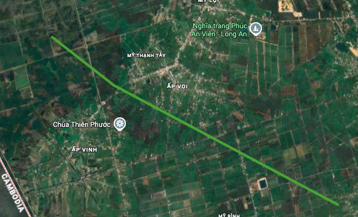
According to the land use planning adjustment map for the period 2021 - 2030 of Duc Hue district, Long An province, a new route named Luong Hoa - My Quy Tay will be built through Dong Thanh commune. This is one of the important traffic infrastructure projects oriented in this period.
Within Dong Thanh commune, this route is expected to be about 13 km long, running near Thien Phuoc pagoda. The project is expected to contribute to completing the traffic network, enhancing regional connectivity and promoting local socio -economic development.
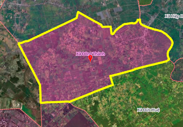
Geographical location of Dong Thanh commune
Dong Thanh commune is a border commune of Duc Hue district, Long An province. The specific location of the commune is as follows:
- North: bordering My Quy and Hiep Hoa communes
- East: bordering Hiep Hoa commune
- South: bordering Duc Hue and Binh Thanh communes
- West: bordering Cambodia
With this strategic location, the development of transport infrastructure such as the Luong Hoa - My Quy Tay route plays an important role in connecting the region and border trade.

Detailed itinerary
Based on the planning map, the Luong Hoa - My Quy Tay route is clearly shown, connecting important areas in the commune and linking with existing routes. The specific route of this route is determined based on the approved land use plan, to optimize connection efficiency and minimize impacts on residential areas.
Note: The planning information in the article is referenced from the Land Use Planning Adjustment Map for the period 2021 - 2030 of Duc Hue district, Long An province. The information may change in the future according to the adjustment decisions of the competent authority.
Source: https://baolamdong.vn/quy-hoach-duong-luong-hoa-my-quy-tay-qua-xa-dong-thanh-long-an-408795.html


Comment (0)