
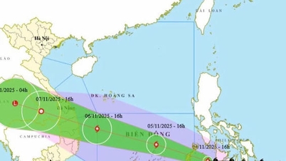
.jpg)
Route DT606 (through the communes of A Vuong, Tay Giang, Hung Son) continues to be congested at km43+300, from km60+000 to km68+000 due to landslides.
Director of Dong Phong Construction and Consulting Joint Stock Company Luong Manh Hung (contractor for management and regular maintenance) said that the local government and the unit mobilized people to lend land to build a temporary road next to it, while waiting for the repair at km43+300. Thus, vehicles can travel from the beginning of the route up to km60+000 (Hung Son commune).
Mr. Hung said that clearing landslides from km60+000 to the end of the route will take a lot of time.
“It is currently raining in the DT606 area, there is a risk of landslides occurring again. The unit is divided into two groups, one group will fix the location at km43+300, the other group will deploy the task from km60+00 and above. Communication is difficult because the phone signal is unstable, sometimes the signal is lost," said Mr. Hung.
On National Highway 40B, Quang Nam Transport Construction Joint Stock Company is the unit that manages and regularly maintains the section from the beginning of the route up to km85+850 (through the wards of Quang Phu, Huong Tra, Tam Ky; communes of Chien Dan, Phu Ninh, Tien Phuoc, Thanh Binh, Lanh Ngoc, Tra My, Tra Tan).
This unit said that it has installed temporary sewers and cleared the route at km82+500 to clear the route. However, it is raining so the progress is slower than expected.
The management unit of the section from km85+850 to km141+080 (in the area of Nam Tra My and Tra Linh communes) is Quang Nam Traffic Construction Joint Stock Company, said that on the morning of November 2, they continued to clear the section from km120 towards the end of the route.
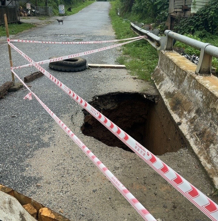
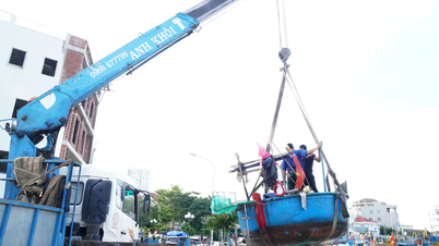
Through actual inspection, the patrol discovered that the reinforced concrete bridge at km114+781 had a landslide on the left side, and the land to build the approach road on the left side of pier M1 collapsed.
Deputy Director of the City Department of Construction Tran Ngoc Thanh said that he has asked the bridge management unit to cover the bottom of the bridge and then pour concrete to fill it in. This must be done quickly to avoid erosion of the approach road.
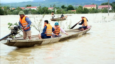
* Faced with the serious landslide situation on the Thu Bon River, in Tinh Yen village (Thu Bon commune) with a length of about 100m, directly threatening many households living in the area, the leaders of Da Nang City Police mobilized 100 officers and soldiers to coordinate with local authorities, militia, army and organizations to quickly build dikes and reinforce the river banks.
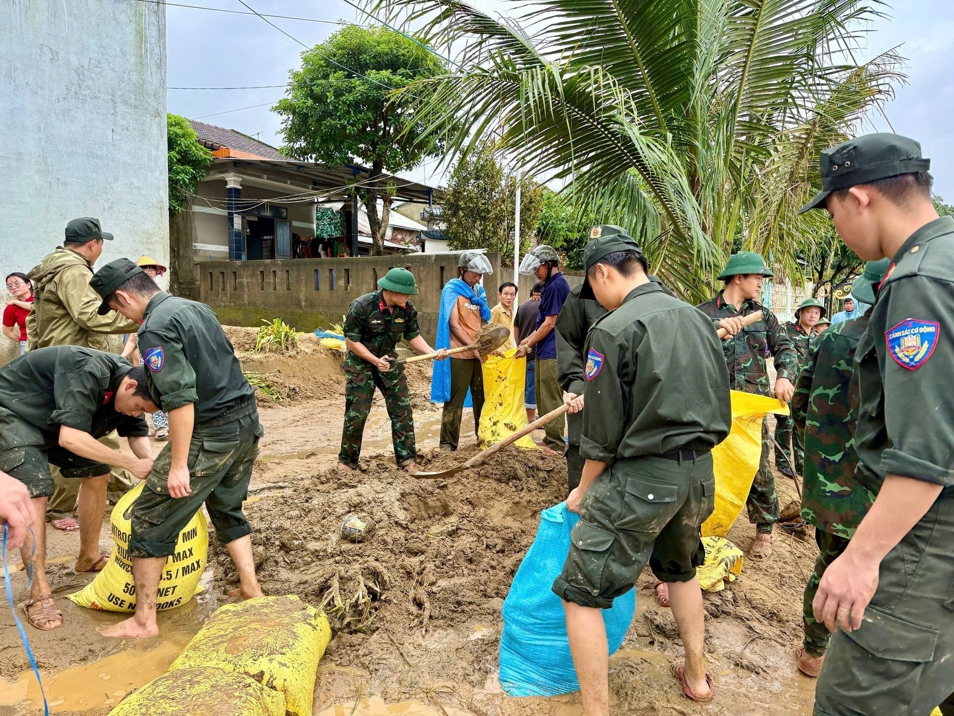
City police officers and soldiers, together with local authorities and soldiers, actively transported sacks of soil and materials, leveled and reinforced the landslide site, preventing the risk of landslides spreading, and ensuring the safety of people and property.

Currently, the landslide area on the Thu Bon river bank has been temporarily repaired, minimizing damage, creating conditions for the government to continue implementing long-term and sustainable treatment measures.
Source: https://baodanang.vn/tap-trung-thong-tuyen-giao-thong-khac-phuc-sat-lo-bo-song-thu-bon-3308979.html
![[Photo] Panorama of the Patriotic Emulation Congress of Nhan Dan Newspaper for the period 2025-2030](https://vphoto.vietnam.vn/thumb/1200x675/vietnam/resource/IMAGE/2025/11/04/1762252775462_ndo_br_dhthiduayeuncbaond-6125-jpg.webp)

![[Photo] The road connecting Dong Nai with Ho Chi Minh City is still unfinished after 5 years of construction.](https://vphoto.vietnam.vn/thumb/1200x675/vietnam/resource/IMAGE/2025/11/04/1762241675985_ndo_br_dji-20251104104418-0635-d-resize-1295-jpg.webp)
![[Photo] Ho Chi Minh City Youth Take Action for a Cleaner Environment](https://vphoto.vietnam.vn/thumb/1200x675/vietnam/resource/IMAGE/2025/11/04/1762233574890_550816358-1108586934787014-6430522970717297480-n-1-jpg.webp)
![[Photo] Ca Mau "struggling" to cope with the highest tide of the year, forecast to exceed alert level 3](https://vphoto.vietnam.vn/thumb/1200x675/vietnam/resource/IMAGE/2025/11/04/1762235371445_ndo_br_trieu-cuong-2-6486-jpg.webp)


Comment (0)