
According to the National Center for Hydro-Meteorological Forecasting, at 1:00 a.m. on November 4, the center of the storm Typhoon Kalmaegi in the central Philippines. The storm increased to level 4 after just over a day with the strongest wind near the storm center at level 13 (134-149 km/h), gusting to level 16, moving quickly in a westerly direction, at a speed of about 25 km/h.
At 1am on November 5, Typhoon Kalmaegi in the western central Philippines changed direction to the West Northwest, moving at 20-25km per hour. The strongest wind near the storm's center was at level 12-13, gusting to level 16.
On the morning of November 5, storm Kalmaegi entered the East Sea, becoming the 13th storm in 2025 to operate in this sea area.
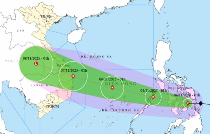
At about 1:00 a.m. on November 6, the storm was in the middle of the East Sea, about 630km east-southeast of the coast of Gia Lai province, moving rapidly in the West-Northwest direction, at a speed of about 25km/h, with the possibility of strengthening to level 14, gusting to level 17. According to current forecasts, this is the maximum intensity of this storm.
At 1am on November 7, storm Kalmaegi was in the coastal waters from Quang Ngai to Dak Lak . The strongest wind near the storm center was level 13, gusting to level 16, moving quickly in the West Northwest direction, traveling about 25km per hour.
From the next 72 to 96 hours, the storm will move mainly in the West-Northwest direction, traveling 20-25km per hour, gradually weakening in intensity.
According to the Department of Hydrometeorology, storm Kalmaegi is moving fast and very strong.
From the night of November 6, the storm is likely to directly affect the area from Da Nang to Khanh Hoa. The strongest wind in coastal areas (including Ly Son special zone) can reach level 12-13, gusting over level 15. Inland coastal areas can reach level 10-12, gusting to level 14-15.
Storms can produce thunderstorms and tornadoes before the storm; widespread heavy rain From the night of November 6 to November 9, the area from Quang Tri to Dak Lak. There is a risk of new floods on rivers from Quang Tri to Khanh Hoa provinces.
In addition, due to the impact of storm Kalmaegi, from around the afternoon of November 4, the sea area east of the central East Sea gradually increased to level 6-7, then increased to level 8-10, the area near the storm center was strong at level 11-13, gusting to level 15-16, waves 5-7m high, and the sea was very rough.
Around November 5-6, the central East Sea area (including Truong Sa special zone), the sea off the coast of Da Nang - Khanh Hoa area may be affected by strong winds of level 12-14, gusts above level 17, waves 8-10m high, and rough seas.
Source: https://baolangson.vn/tin-bao-kalmaegi-moi-nhat-giat-cap-16-du-bao-mua-lon-o-quang-tri-dak-lak-5063826.html


![[Photo] Panorama of the Patriotic Emulation Congress of Nhan Dan Newspaper for the period 2025-2030](https://vphoto.vietnam.vn/thumb/1200x675/vietnam/resource/IMAGE/2025/11/04/1762252775462_ndo_br_dhthiduayeuncbaond-6125-jpg.webp)

![[Photo] The road connecting Dong Nai with Ho Chi Minh City is still unfinished after 5 years of construction.](https://vphoto.vietnam.vn/thumb/1200x675/vietnam/resource/IMAGE/2025/11/04/1762241675985_ndo_br_dji-20251104104418-0635-d-resize-1295-jpg.webp)
![[Photo] Opening of the 14th Conference of the 13th Party Central Committee](https://vphoto.vietnam.vn/thumb/1200x675/vietnam/resource/IMAGE/2025/11/05/1762310995216_a5-bnd-5742-5255-jpg.webp)


Comment (0)