
Latest updates on Typhoon TRAMI
Early morning on October 22nd, The tropical depression over the sea east of the Philippines has strengthened into a typhoon and has been given the international name... TRAMI.
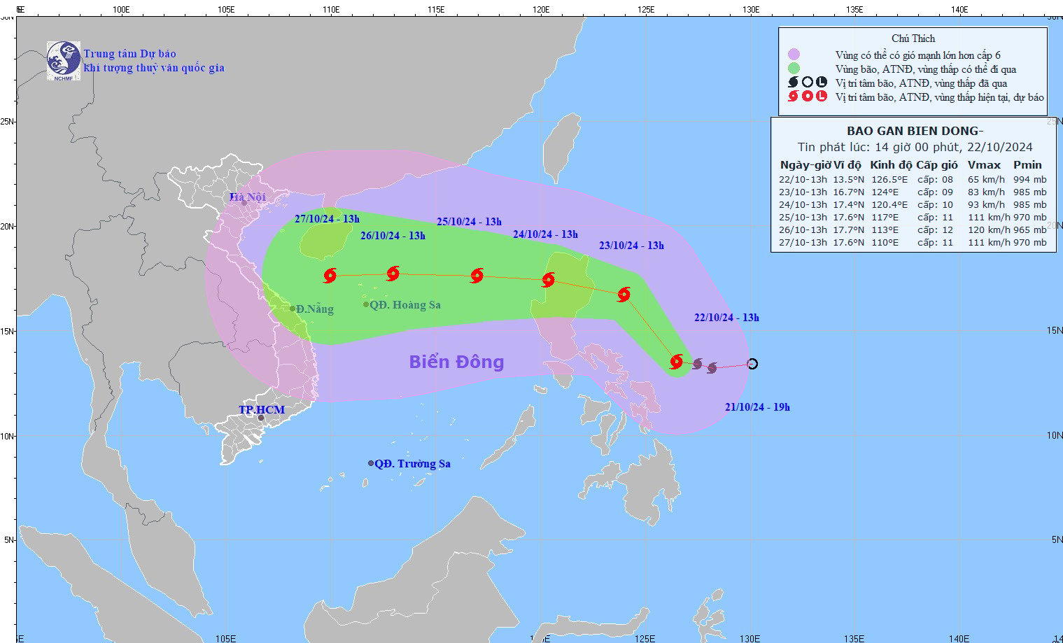
Updated location and trajectory of Typhoon TRAMI. Photo: NCHMF
At 13:00, the typhoon's center was located at approximately 13.5 degrees North latitude and 126.5 degrees East longitude, over the sea east of central Philippines. The strongest winds near the center of the typhoon were at level 8 (62-74 km/h), with gusts up to level 10. It was moving northwest at a speed of 15-20 km/h.
Forecast of the development of Typhoon TRAMI over the next 24 to 72 hours.
Forecast time | Direction, speed | Location | Intensity | Hazardous area | Level of natural disaster risk (Affected area) |
13:00/23/10 | Northwest, Approximately 15 km/h | 16.7N-124.0E; in the sea area to the south Eastern Luzon (Philippines) | Level 9, then level 11 | Latitude 14.0N-19.0N; East of longitude 122.0E | |
13:00/24/10 | West-Northwest, 15-20 km/h | 17.4N-120.4E; on the western coast of Luzon Island | Level 10, then level 12 | Latitude 15.0N-19.0N; East of longitude 118.0E | High school: East of the North South China Sea region |
13:00/25/10 | West, At approximately 15 km/h , it entered the South China Sea. | 17.6N-117.0E; in the eastern part of the North East Sea, 550km east-northeast of the Paracel Islands. | Level 11, then level 14 | Latitude 15.0N-20.0N; East of longitude 115.0E | High school: East of the North South China Sea region |
Warning regarding the development of Typhoon TRAMI over the next 72 to 120 hours.
Over the next 72 to 120 hours, the storm will move mainly westward at a speed of 15-20 km per hour , continuing to intensify.
Forecast of the impact of Typhoon TRAMI
At sea: In the eastern part of the North East Sea, winds will be strong, force 6-7. From the morning of October 24th, winds will increase to force 8-9, reaching force 10-11 near the storm's center, with gusts up to force 14. Sea waves will be 4.0-6.0m high, and 6.0-8.0m near the center; the sea will be extremely rough.
Vessels operating in the aforementioned hazardous areas are susceptible to the effects of thunderstorms, tornadoes, strong winds, and high waves.
Source: https://danviet.vn/cap-nhat-tin-bao-trami-moi-nhat-vao-bien-dong-bao-trami-manh-cap-may-20241022144222947.htm


Comment (0)