
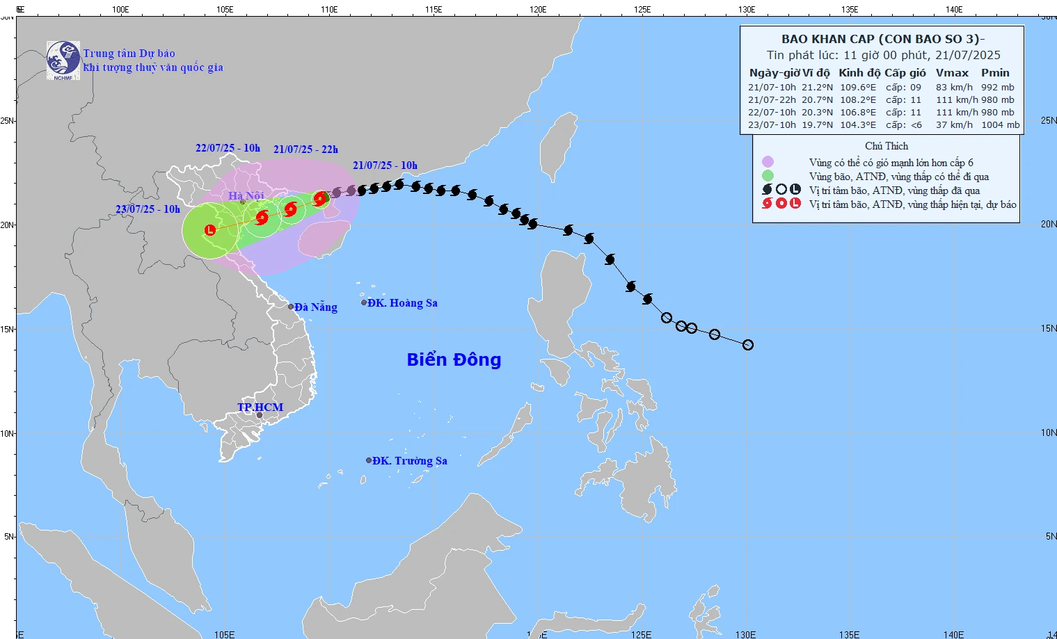
The predicted path of Typhoon No. 3 as of 11:00 AM on July 21, 2025.
At 10:00 AM, the storm's center was located at approximately 21.2 degrees North latitude and 109.6 degrees East longitude, about 190km from Quang Ninh and 310km from Hai Phong ; the strongest winds near the storm's center were at level 9 (75-88km/h), with gusts up to level 11; it was moving in a west-southwest direction at a speed of 10-15km/h.
Forecasts indicate that at 10 PM on July 21st, the storm's center will be located at approximately 20.7 degrees North latitude and 108.2 degrees East longitude (northern Gulf of Tonkin). Its intensity will be level 10-11, with gusts up to level 14.
As of 10:00 AM on July 22nd, the storm's center was located at approximately 20.3 degrees North latitude and 106.8 degrees East longitude (in the sea area between Hai Phong and Thanh Hoa ). Its intensity was level 10-11, with gusts up to level 14.
By 10:00 AM on July 23rd, the storm's center was located at approximately 19.7 degrees North latitude and 104.3 degrees East longitude (over the Upper Laos mainland), having weakened into a low-pressure system.
In the northwestern part of the South China Sea, there will be winds of force 7-8, gusting to force 10; waves 3-5m high; and rough seas.
The northern part of the Gulf of Tonkin (Bach Long Vi, Co To, Van Don, Cat Hai, Hon Dau) will experience winds of force 6-7, later increasing to force 8-9, with winds near the storm's center reaching force 10-11, gusting to force 14; waves 4-6m; extremely rough seas.
In the southern part of the Gulf of Tonkin (near Hon Ngu Island), winds are gradually increasing to force 6-7, reaching force 8-9 near the storm's center, with gusts up to force 11; waves are 2-4 meters high; the sea is very rough.
From July 21-23, rainfall in the Northeast, Northern Delta, Thanh Hoa, and Nghe An will generally range from 200-350mm, with some areas exceeding 600mm. Other areas in Northern Vietnam and Ha Tinh will experience rainfall of 100-200mm, with some areas exceeding 300mm. There is a risk of extremely heavy rainfall (>150mm/3h), flash floods, landslides, and flooding in low-lying areas.
The level of natural disaster risk in the Gulf of Tonkin, coastal areas, and inland areas from Quang Ninh to Nghe An is level 3.
NDS
Source: https://baothanhhoa.vn/bao-so-3-da-di-vao-vinh-bac-bo-cach-quang-ninh-190km-255548.htm

![[Photo] Prime Minister Pham Minh Chinh holds a phone call with the CEO of Russia's Rosatom Corporation.](/_next/image?url=https%3A%2F%2Fvphoto.vietnam.vn%2Fthumb%2F1200x675%2Fvietnam%2Fresource%2FIMAGE%2F2025%2F12%2F11%2F1765464552365_dsc-5295-jpg.webp&w=3840&q=75)


![[Photo] Closing Ceremony of the 10th Session of the 15th National Assembly](/_next/image?url=https%3A%2F%2Fvphoto.vietnam.vn%2Fthumb%2F1200x675%2Fvietnam%2Fresource%2FIMAGE%2F2025%2F12%2F11%2F1765448959967_image-1437-jpg.webp&w=3840&q=75)


![[OFFICIAL] MISA GROUP ANNOUNCES ITS PIONEERING BRAND POSITIONING IN BUILDING AGENTIC AI FOR BUSINESSES, HOUSEHOLDS, AND THE GOVERNMENT](https://vphoto.vietnam.vn/thumb/402x226/vietnam/resource/IMAGE/2025/12/11/1765444754256_agentic-ai_postfb-scaled.png)


Comment (0)