
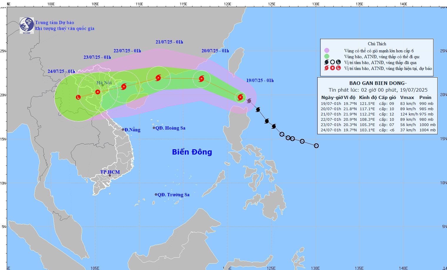
Predicted path of Typhoon Wipha at 2:00 AM on July 19, 2025. (Image: nchmf)
According to the National Center for Hydro-Meteorological Forecasting, at 1:00 AM on July 19th, Typhoon Wipha was located at approximately 19.7 degrees North latitude and 121.5 degrees East longitude, in the sea north of Luzon Island (Philippines). The typhoon was moving northwest at a speed of about 20 km/h; the strongest winds were at level 9 (75-88 km/h), with gusts up to level 11.
The forecast indicates that around 1 AM tomorrow (July 20th), the storm will enter the South China Sea. The storm's center will be located at 21.8 degrees North latitude and 117.1 degrees East longitude, in the northeastern part of the South China Sea, approximately 760km east of the Leizhou Peninsula (China). Its intensity is currently level 10, with gusts up to level 12, and it has the potential to strengthen further.
At 1:00 AM on July 21st, the storm was mainly moving westward at about 20 km/h, with its center located approximately 210 km east-northeast of the Leizhou Peninsula (China). Its intensity was level 11-12, with gusts up to level 14.
Around 1:00 AM on July 22nd, the storm moved in a west-southwest direction, located at 20.9 degrees North latitude and 108.3 degrees East longitude, over the Gulf of Tonkin, and gradually weakened.
Forecast of storm developments (over the next 24 to 72 hours).
Warning: Over the next 72 to 120 hours, the storm will move mainly in a west-southwest direction, traveling at 10-15 km per hour, and gradually weakening.
Due to the influence of the storm's circulation, the eastern part of the North East Sea will experience increasingly strong winds, reaching levels 6-7, and near the storm's center levels 8-10, with gusts up to level 12. Sea waves will be 3-5 meters high. The sea will be very rough. Ships in the danger zone are at high risk of being affected by tornadoes, strong winds, and large waves.
NDS
Source: https://baothanhhoa.vn/du-bao-bao-wipha-di-vao-bien-dong-tro-thanh-con-bao-so-3-255263.htm

![[Photo] General Secretary and President To Lam presides over a meeting with the Central Organizing Committee.](https://vphoto.vietnam.vn/thumb/1200x675/vietnam/resource/IMAGE/2026/06/03/1780482764658_a1-bnd-4741-3342-jpg.webp)
![[Photo] Secretary of the National Assembly Party Committee, Chairman of the National Assembly presides over the meeting of the Standing Committee and Executive Committee of the National Assembly Party Committee.](https://vphoto.vietnam.vn/thumb/1200x675/vietnam/resource/IMAGE/2026/06/03/1780480353201_ndo_br_bnd-2585-jpg.webp)

![[Photo] First session of the 14th Congress of the Vietnam Trade Union](https://vphoto.vietnam.vn/thumb/1200x675/vietnam/resource/IMAGE/2026/06/03/1780465947883_ndo_br_img-3852-jpg.webp)


![[Video] Sunset at Lap An Lagoon – Where the sun sets over the fishing nets](https://vphoto.vietnam.vn/thumb/1200x675/vietnam/resource/IMAGE/2026/05/31/1780192137701_beach-landscape-sea-water-nature-grass-745871-pxhere-com.jpeg)


Comment (0)