
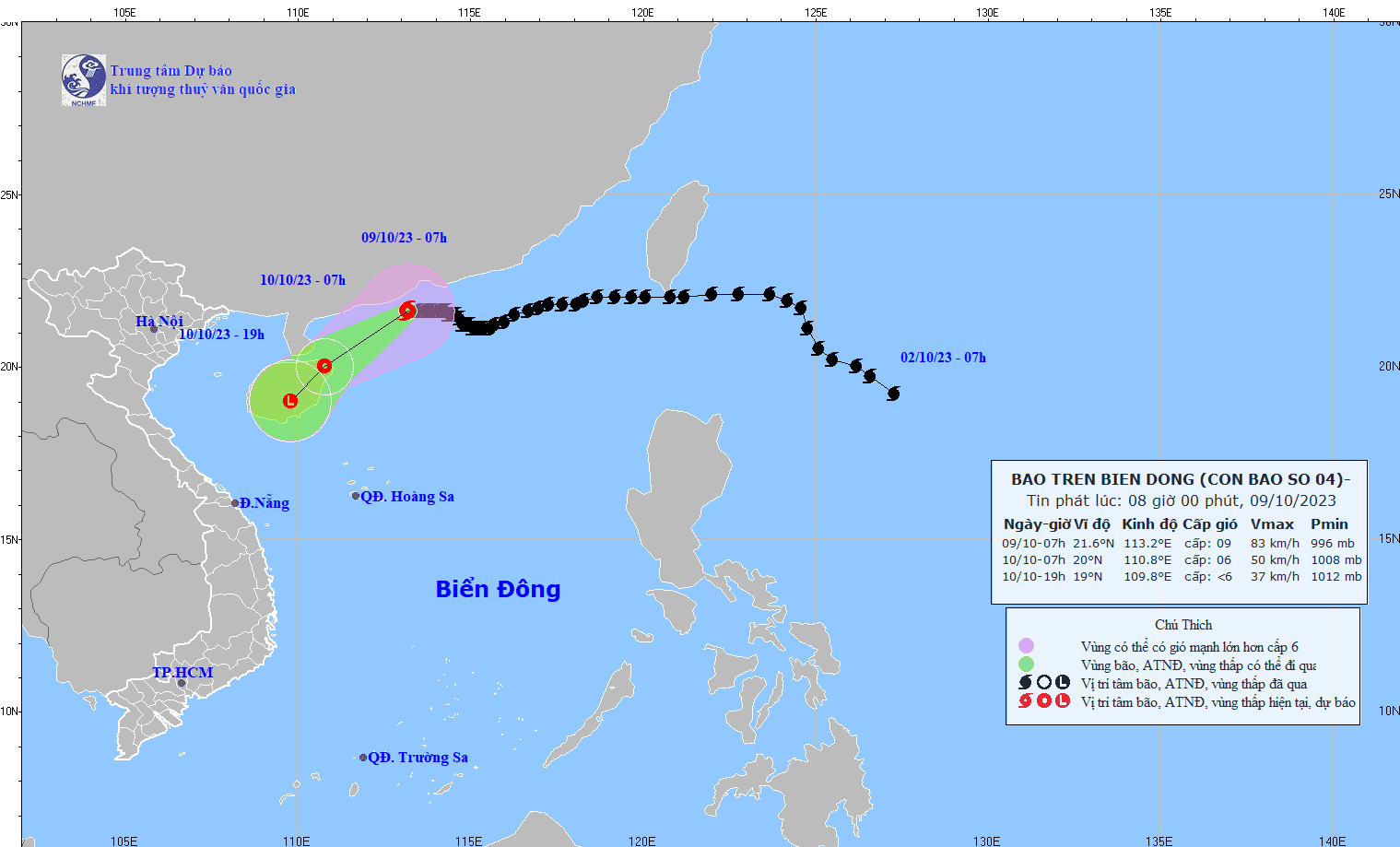
At 7:00 AM on October 9th, the center of Typhoon No. 4 was located at approximately 21.6 degrees North latitude and 113.2 degrees East longitude, in the sea south of Guangdong province (China). The strongest winds near the center of the typhoon were at level 9 (75-88 km/h), with gusts up to level 12, moving slowly westward at a speed of about 5 km/h.
Forecasts indicate that by 7:00 AM on October 10th, Typhoon No. 4 will be located in the northeastern area of Hainan Island (China), with maximum wind speeds near the center reaching levels 6-7, gusting to level 9, moving southwest at a speed of 10-15 km/h and weakening into a tropical depression.
By 7 PM on October 10th, Typhoon No. 4, located over Hainan Island, had maximum wind speeds near its center below level 6, continuing to move southwest at a speed of 10-15 km/h and weakening into a low-pressure area.
According to the meteorological agency, over the next 24 hours, the northwestern sea area of the North East Sea will experience strong winds of force 6-7, with winds near the storm's center reaching force 8-9, gusting to force 12; the sea will be very rough. In addition, due to the influence of a strengthening cold front, from early morning on October 10th, the Gulf of Tonkin will experience strong northeast winds of force 6, gusting to force 8; the sea will be rough.
In the northern South China Sea, waves are 2-3 meters high, and near the storm's center, waves are 3-5 meters high. From the morning of October 10th, waves in the Gulf of Tonkin were 2-3 meters high. All vessels operating in these areas were affected by strong winds and high waves.
Source
![[Photo] Closing Ceremony of the 10th Session of the 15th National Assembly](/_next/image?url=https%3A%2F%2Fvphoto.vietnam.vn%2Fthumb%2F1200x675%2Fvietnam%2Fresource%2FIMAGE%2F2025%2F12%2F11%2F1765448959967_image-1437-jpg.webp&w=3840&q=75)

![[Photo] Prime Minister Pham Minh Chinh holds a phone call with the CEO of Russia's Rosatom Corporation.](/_next/image?url=https%3A%2F%2Fvphoto.vietnam.vn%2Fthumb%2F1200x675%2Fvietnam%2Fresource%2FIMAGE%2F2025%2F12%2F11%2F1765464552365_dsc-5295-jpg.webp&w=3840&q=75)


![[OFFICIAL] MISA GROUP ANNOUNCES ITS PIONEERING BRAND POSITIONING IN BUILDING AGENTIC AI FOR BUSINESSES, HOUSEHOLDS, AND THE GOVERNMENT](https://vphoto.vietnam.vn/thumb/402x226/vietnam/resource/IMAGE/2025/12/11/1765444754256_agentic-ai_postfb-scaled.png)


Comment (0)