
How strong is storm Tra Mi? When will storm Tra Mi enter the East Sea?
According to the latest storm Tra Mi - storm Kristine bulletin of the Philippine Atmospheric, Geophysical and Astronomical Services Administration (PAGASA), at 4:00 a.m. on October 22, the center of storm Tra Mi (international name: storm Kristine) was at about 13.2 degrees north latitude, 127.8 degrees east longitude, 390km east of Virac, Catanduanes, Philippines.
The strongest wind near the center of storm Tra Mi reached 65 km/h, gusting up to 80 km/h. Currently, storm Tra Mi is moving west at a speed of 15 km/h.
Kristine could reach severe tropical storm status tomorrow (October 23) and could make landfall on Isabela as a severe tropical storm.
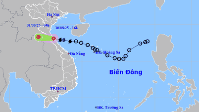
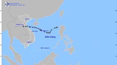
Meanwhile, the National Center for Hydro-Meteorological Forecasting predicts that the storm will move mainly in the West-Northwest direction.
As of 4 p.m. on October 22, the eye of the storm was located in the sea east of the Philippines. The strongest wind near the eye of the storm was level 8 (62-75 km/h), gusting to level 11. Waves were 3-4 m high.
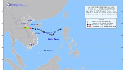
Vietnam's meteorological agency said that around October 25, the storm is likely to move into the East Sea, becoming storm number 6.
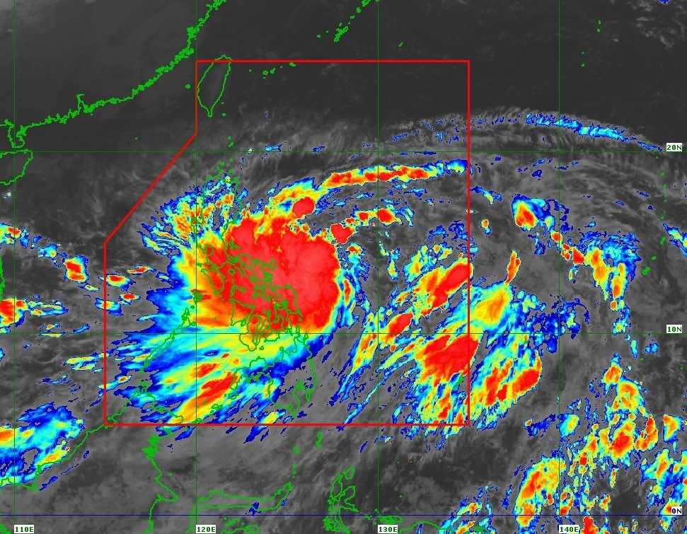
The movement of storm Tra Mi. Photo: PACASA.
"It is forecasted that around October 25, the storm is likely to move into the East Sea. From around the afternoon and night of October 24, the eastern sea area of the North East Sea (east of the 118.5 degree East longitude) will have winds gradually increasing to level 8, the area near the storm's center will be level 9-10, gusting to level 12 ; very rough seas, waves 3.0-5.0m high, thunderstorms with dangerous whirlwinds," the National Center for Hydro-Meteorological Forecasting said.
Proactively respond to the tropical depression that has strengthened into storm Tra Mi
To proactively respond to the tropical depression that has strengthened into storm Tra Mi, the Ministry of Agriculture and Rural Development also issued Official Dispatch No. 7930/CD-BNN-DD dated October 21, 2024 requesting ministries, branches, and Chairmen of People's Committees of coastal provinces and cities from Quang Ninh to Binh Dinh to closely monitor forecasts and warnings; notify captains and owners of vehicles and boats (including cruise ships) operating at sea to proactively prevent and have appropriate production plans, ensuring safety of people and property; maintain communication to promptly handle bad situations that may occur. Be ready with forces and means for rescue when requested.
Deploy shock troops to inspect and review residential areas along rivers, streams, low-lying areas, and areas at high risk of flooding, flash floods, and landslides; proactively evacuate people in dangerous areas to safety.
Organize forces to guard, control, and guide traffic safety for people and vehicles, especially at culverts, spillways, deep flooded areas, areas with strong currents, areas where landslides have occurred or are at risk of landslides; arrange forces, materials, and vehicles to handle incidents, and ensure smooth traffic on main traffic routes.
Organize operations and implement plans to ensure the safety of reservoirs and downstream areas, especially small hydropower reservoirs, important irrigation reservoirs, and projects under construction; arrange permanent forces to operate and regulate and be ready to handle possible situations.
Source: https://danviet.vn/nong-bao-tra-mi-duoc-du-bao-giat-toi-cap-12-bao-gio-vao-bien-dong-thanh-bao-so-6-20241022101540969.htm
![[Photo] National Assembly Chairman Tran Thanh Man attends the VinFuture 2025 Award Ceremony](/_next/image?url=https%3A%2F%2Fvphoto.vietnam.vn%2Fthumb%2F1200x675%2Fvietnam%2Fresource%2FIMAGE%2F2025%2F12%2F05%2F1764951162416_2628509768338816493-6995-jpg.webp&w=3840&q=75)


![[Photo] 60th Anniversary of the Founding of the Vietnam Association of Photographic Artists](/_next/image?url=https%3A%2F%2Fvphoto.vietnam.vn%2Fthumb%2F1200x675%2Fvietnam%2Fresource%2FIMAGE%2F2025%2F12%2F05%2F1764935864512_a1-bnd-0841-9740-jpg.webp&w=3840&q=75)


Comment (0)