

2025 is recorded as a year with extremely unusual and abnormal natural disasters, causing serious damage across the country.
2025 is the year of the most unusual natural disaster in history
According to the assessment of the World Meteorological Organization, the year 2025 has witnessed many records of hydrometeorological disasters. In the world, many records of the highest temperature in many places were recorded exceeding 48 degrees Celsius, setting a new record for the number of consecutive days with maximum temperature (United States, Turkey, July 2025). The year 2025 also recorded 10 major storms (level 3 or higher), surpassing previous records. The phenomenon of storms rapidly intensifying has become common. Super typhoon "Phoenix" in the Northwest Pacific has increased from level 1 to level 5 (wind speed over 250 km/h in just 24 hours (September 2025).
In addition, many floods, inundations and flash floods were also recorded, especially extremely serious floods and landslides such as in Sumatra, Indonesia (November-December 2025) causing over 700 deaths and hundreds of missing people, Pakistan (June-June 2025) causing more than 1,000 deaths...
Notably, Bach Ma station (Vietnam) recorded an extreme rainfall of up to 1,739 mm in just 24 hours (October 2025). The World Meteorological Organization is confirming this as one of the largest known 24-hour rainfall events in the world.
In Vietnam, 2025 is recorded as a year with extremely unusual and abnormal natural disasters, causing serious damage across the country.
By the end of November 2025, there were 21 storms/tropical depressions (15 storms, 6 tropical depressions) active in the East Sea, and 2025 became the year with the highest number of storms/tropical depressions active in the East Sea since observation data began (since 1961). Previously, the year with the highest number was 2017 with 20 storms/tropical depressions (16 storms, 4 tropical depressions).
In addition to the record number of storms/tropical depressions, the 2025 storm season also recorded a number of special, unusual and extreme characteristics such as: Storm No. 1 (WUTIP) was the first storm to appear in the East Sea in June after more than 40 years. Storm No. 9 (RAGASA) with a strong intensity of level 17, gusting above level 17, became the strongest storm ever active in the East Sea; Tropical depression at the end of November, originating from storm Senyar, moved from the Indian Ocean to the Northwest Pacific (in the past, there have been tropical depressions or storms moving from the West Pacific to the Indian Ocean, but the opposite direction has never been recorded in meteorological history).
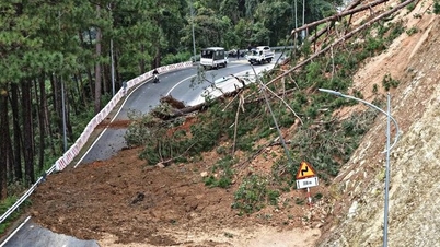
In 2025, severe flooding occurred on a large scale, with peak flood levels on rivers exceeding historical levels in the North, Central, Central Highlands, and the lower Mekong River. No year has recorded exceptionally large floods or historical floods occurring in one year on 20 rivers such as Cau River (Thai Nguyen, Bac Ninh), Thuong River (Bac Ninh), Chung River (Lang Son), Bang Giang River (Cao Bang), Lo River (Tuyen Quang), Ngoi Hut River, Ngoi Thia River (Lao Cai), the upper reaches of Ma River and Buoi River, Yen River (Thanh Hoa), the upper reaches of Ca River (Nghe An), Bo River (Hue City), Vu Gia-Thu Bon River (Da Nang), Ky Lo River, Ba River (Dak Lak), Dinh Ninh Hoa River (Khanh Hoa), Luy River (Lam Dong), the lower reaches of Tien River (Vinh Long, Dong Thap), and the lower reaches of Hau River (An Giang, Can Tho).
Particularly serious was the historic flood in Phu Yen (now the eastern region of Dak Lak province), which was assessed to have surpassed the historic flood peak in 1993 on the Ba River basin.
According to Mr. Hoang Duc Cuong, Deputy Director of the Department of Hydrometeorology, Ministry of Agriculture and Environment, unusual storm activity and unusually severe and widespread floods in 2025 in Vietnam as well as in the world are clear evidence that traditional flood rules are changing, reflecting the increasingly extreme and unpredictable weather trends due to the impact of climate change.
Forecast of natural disasters in late 2025 and early 2026
According to the National Center for Hydro-Meteorological Forecasting, from December 2025 to February 2026, ENSO is likely to continue to maintain La Nina status, then from March to May 2026, ENSO is likely to return to neutral status. In December 2025, there is a possibility of 1-2 storms/tropical depressions appearing in the East Sea. From January to May 2026, there is a low possibility of storms/tropical depressions appearing in the East Sea.
Currently, in the eastern sea of the central Philippines, there is a tropical depression located at about 14 degrees North latitude -135 degrees East longitude, moving slowly in a northwest direction. It is forecasted that around December 6-7, this tropical depression will likely pass through the central region of the Philippines and enter the East Sea, possibly strengthening into a storm (storm No. 16). The storm is likely to directly affect the mainland of the Central and South Central regions, causing moderate to heavy rain in the provinces from Hue City to Khanh Hoa.
In December 2025, in the Central and South Central regions, there is a possibility of 1-2 widespread moderate and heavy rains, in which rainfall in the area from South Quang Tri to the northern part of the South Central Coast tends to be higher than the average of many years, so it is necessary to guard against the risk of flash floods and landslides.
In December 2025, cold air continues to increase in frequency and intensity, and severe cold may appear in the North, but concentrated in the northern mountainous areas. Cold air continues to be active in January and February 2026, causing severe cold spells.
The Southern region is likely to experience heat waves from around early March 2026 in the Southeast region; then from late March to early April 2026, heat waves tend to increase in intensity and gradually expand to the Southwest region (equivalent to the average of many years). The Northwest region and the area from Thanh Hoa to Hue are likely to experience heat waves from around April 2026.
Thu Cuc
Source: https://baochinhphu.vn/thien-tai-cuc-ky-di-thuong-kha-nang-con-1-2-con-bao-tren-bien-dong-102251204135145093.htm


![[Photo] Cat Ba - Green island paradise](/_next/image?url=https%3A%2F%2Fvphoto.vietnam.vn%2Fthumb%2F1200x675%2Fvietnam%2Fresource%2FIMAGE%2F2025%2F12%2F04%2F1764821844074_ndo_br_1-dcbthienduongxanh638-jpg.webp&w=3840&q=75)


![[VIMC 40 days of lightning speed] Da Nang Port: Unity - Lightning speed - Breakthrough to the finish line](https://vphoto.vietnam.vn/thumb/402x226/vietnam/resource/IMAGE/2025/12/04/1764833540882_cdn_4-12-25.jpeg)


Comment (0)