
On land, strong northeast winds of level 2-3, coastal areas of level 3-4. Due to the influence of strengthening cold air, from November 3-4, the Northern region, Thanh Hoa and northern Nghe An will have rain in many places. The weather is cold, with some high mountainous areas experiencing severe cold.
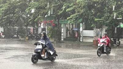
In Hanoi , from November 3-4, there will be rain and cold weather, with the lowest temperature commonly ranging from 17-19 degrees Celsius.
Cold air combined with disturbances in the upper easterly wind zone caused the area from South Nghe An to Quang Ngai to continue to have widespread heavy rain. On the morning of November 3, the area from South Ha Tinh to Da Nang City had moderate rain, heavy rain, and locally very heavy rain, with Da Nang City alone recording exceptionally heavy rain.

It is forecasted that from now until the end of November 4, the area from South Quang Tri to Da Nang City will have heavy to very heavy rain, total rainfall of 200-300 mm, locally over 600 mm. The area of Ha Tinh, North Quang Tri and East Quang Ngai will have rain of 100-200 mm, some places over 350 mm; the area of South Nghe An and West Quang Ngai will have moderate to heavy rain.
Currently, the water level on Vu Gia - Thu Bon River (Da Nang) is rising, the flood on Bo River, Huong River (Hue City) is fluctuating, the downstream of Ngan Sau River (Ha Tinh) and Tra Khuc River (Quang Ngai) is changing slowly. In the next 12 hours, the flood on Vu Gia - Thu Bon River will continue to rise above alert level 3, the flood on Huong River and Bo River will fluctuate below alert level 3.
It is forecasted that from now until November 5, floods on rivers in Ha Tinh, Quang Tri and Quang Ngai are likely to rise again, the flood peak may reach alert level 2-3. There is a risk of flooding in low-lying areas, riverside residential areas, urban areas, and a high risk of flash floods and landslides in provinces from Ha Tinh to Quang Ngai.
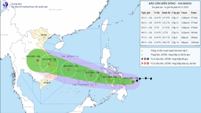
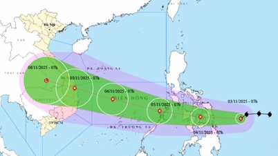
At sea, the tropical convergence zone connects with the low pressure area and is very active. The Gulf of Tonkin has northeast winds of level 6-7, gusts of level 8-9, rough seas, and waves of 2.5-3.5 m high. The North East Sea (including the Hoang Sa sea area) has winds of level 6-7, gusts of level 8-9, and waves of 3.0-5.0 m high. Other sea areas have scattered showers and thunderstorms, with the possibility of tornadoes and strong gusts of level 6-7 in thunderstorms.
Weather forecast for regions across the country:
Hanoi capital is cloudy, rainy. Northeast wind level 2-3. Cold. Lowest temperature 17-19 degrees Celsius. Highest temperature 19-21 degrees Celsius.
The Northwestern provinces are cloudy and rainy. Light wind. Cold weather, some places are very cold; especially Dien Bien-Lai Chau. Lowest temperature 16-19 degrees Celsius, some places below 15 degrees Celsius. Highest temperature 19-22 degrees Celsius, especially Lai Chau-Dien Bien 22-25 degrees Celsius.
The Northeast region is cloudy and rainy. Northeast wind level 2-3, coastal areas level 3-4. Cold weather, some places in the highlands are very cold. Lowest temperature 16-19 degrees Celsius, some places in the mountains are below 15 degrees Celsius. Highest temperature 19-22 degrees Celsius.
Provinces from Thanh Hoa to Hue are cloudy with moderate to heavy rain, some places have very heavy rain and thunderstorms; especially the area from Ha Tinh to Hue City has heavy to very heavy rain. North to northwest wind level 2-3, coastal areas level 3-4. In the North, it is cold. During thunderstorms, there is a possibility of tornadoes, lightning and strong gusts of wind. Lowest temperature 19-22 degrees Celsius. Highest temperature in the North 21-23 degrees Celsius, in the South 24-26 degrees Celsius.
South Central Coast: In the North, it is cloudy with heavy to very heavy rain and thunderstorms; in the South, it is cloudy with scattered showers and thunderstorms, with scattered showers and thunderstorms in the afternoon and evening, with some heavy rain in some places. In the North, the wind is from the east to northeast at level 2-3; in the South, the wind is from the southwest at level 2-3. There is a possibility of tornadoes, lightning and strong gusts of wind during thunderstorms. Lowest temperature 22-25 degrees Celsius. Highest temperature in the North: 25-28 degrees Celsius; in the South: 29-32 degrees Celsius.
Central Highlands: Cloudy, scattered showers and thunderstorms, locally heavy rain (rain concentrated in the afternoon and evening). Light wind. Thunderstorms may cause tornadoes, lightning, hail and strong gusts of wind. Lowest temperature 18-21 degrees Celsius. Highest temperature 24-27 degrees Celsius.
The South is cloudy with scattered showers and thunderstorms, with some places experiencing heavy rain (rain concentrated in the afternoon and at night). Southwest to west wind level 2-3. During thunderstorms, there is a possibility of tornadoes, lightning, hail and strong gusts of wind. Lowest temperature 23-26 degrees Celsius. Highest temperature 30-33 degrees Celsius.
Ho Chi Minh City is cloudy with scattered showers and thunderstorms, with some places experiencing heavy rain (rain concentrated in the afternoon and at night). Southwest to west winds at level 2-3. During thunderstorms, there is a possibility of tornadoes, lightning, hail and strong gusts of wind. Lowest temperature 24-26 degrees Celsius. Highest temperature 31-33 degrees Celsius.
Source: https://baotintuc.vn/xa-hoi/thoi-weather-ngay-311-khong-khi-lanh-tang-cuong-bac-bo-troi-ret-trung-trung-bo-mua-to-20251103060022501.htm
![[Photo] Prime Minister Pham Minh Chinh receives the Chairman of the Japan-Vietnam Friendship Association in the Kansai region](https://vphoto.vietnam.vn/thumb/1200x675/vietnam/resource/IMAGE/2025/11/03/1762176259003_ndo_br_dsc-9224-jpg.webp)

![[Photo] General Secretary To Lam receives Singaporean Ambassador Jaya Ratnam](https://vphoto.vietnam.vn/thumb/1200x675/vietnam/resource/IMAGE/2025/11/03/1762171461424_a1-bnd-5309-9100-jpg.webp)
![[Photo] Lam Dong: Close-up of illegal lake with broken wall](https://vphoto.vietnam.vn/thumb/1200x675/vietnam/resource/IMAGE/2025/11/03/1762166057849_a5018a8dcbd5478b1ec4-jpg.webp)


Comment (0)