
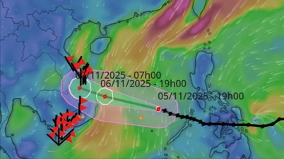
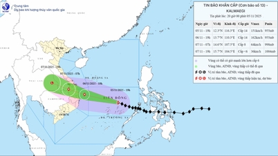
According to the National Center for Hydro-Meteorological Forecasting at 5:00 a.m. on November 5, storm Kalmaegi crossed the northern area of Palawan Island of the Philippines and entered the eastern sea area of the central area of the East Sea, becoming storm No. 13, with intensity of level 13 and gusts of level 16.
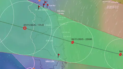
Forecast around afternoon of November 6, the storm will enter the sea area of Da Nang - Khanh Hoa.
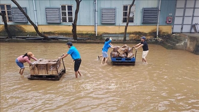
 to continue to strengthen")
Storm Kalmaegi (storm number 13) will continue to strengthen when entering the East Sea. PHOTO: VNDMS
Around the night of November 6 (after 9:00 p.m.) to early morning of November 7, the storm made landfall in the provinces from Quang Ngai to Dak Lak , then moved to Laos, weakened into a tropical depression and gradually dissipated.
According to the National Center for Hydro-Meteorological Forecasting, the storm is very strong, moving quickly, has a wide circulation, operates on the tropical convergence zone, the sea surface temperature is still high, the atmosphere is humid, and the cold air is weakening. Therefore, the storm is likely to strengthen after entering the East Sea.
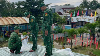
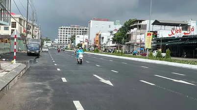
Up to now, international and Vietnamese forecasts are relatively consistent on the trajectory and intensity of storm Kalmaegi. Assessing the impact of the storm on the mainland, the National Center for Hydro-Meteorological Forecasting said that from the evening of November 6, on the mainland along the coast from southern Quang Tri - Da Nang, the eastern provinces from Quang Ngai - Dak Lak, the wind will gradually increase to level 6 - 7, then increase to level 8 - 9, the area near the storm's center will be strong at level 10 - 12 (focusing on the eastern provinces of Quang Ngai - Dak Lak), gusting at level 14 - 15. The strongest wind is forecasted from the evening of November 6 to the morning of November 7.
In the west of Quang Ngai and Gia Lai provinces, the wind will gradually increase to level 6 - 7, near the storm's eye it will be level 8, gusting to level 10.
According to the National Center for Hydro-Meteorological Forecasting, storm No. 3 has a similar path and impact to storm No. 12 (storm Damrey) in 2017 and storm No. 9 (storm Molave) in 2020.
Storm Kalmaegi made landfall in Phu Yen and Khanh Hoa provinces with a strong intensity of level 9. In Khanh Hoa, there were strong gusts of wind at level 12 - 13. In Gia Lai and Dak Lak (formerly Binh Dinh and Phu Yen), Lam Dong, there were strong gusts of wind at level 10 - 11.
The common rainfall in the Hue - Khanh Hoa area is about 150 - 250 mm, Gia Lai - Dak Lak is about 80 - 150 mm, some places have heavier rain such as: Nam Dong (Hue) 321 mm; Tam Ky, Tien Phuoc (Quang Nam) 280 mm; Ba To 338 mm; Son Giang (Quang Ngai) 382 mm; An Nhon 296 mm, Quy Nhon (Gia Lai) 295 mm; An Khe 266 mm; Krong Pa (Gia Lai) 237 mm.
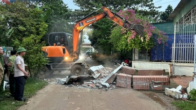
When making landfall in Quang Ngai - Da Nang provinces, storm Kalmaegi had a strong intensity of level 11 - 12, gusting to level 14. Ly Son Special Zone (Quang Ngai) had strong winds of level 12, gusting to level 13 - 14. The storm caused heavy rain of 150 - 400 mm in many places from Nghe An - Dak Lak.
The National Center for Hydro-Meteorological Forecasting said that under the influence of heavy rains caused by storm Kalmaegi (storm No. 13), rivers from Quang Tri to Khanh Hoa are likely to experience a new flood. In particular, the flood level and inundation on river systems in Hue and Da Nang are likely not as serious as the recent flood./.
According to Thanh Nien Newspaper
Source: https://thanhnien.vn/3-yeu-to-tren-bien-khien-bao-kalmaegi-bao-so-13-tiep-tuc-manh-len-185251105081724987.htm
Source: https://baolongan.vn/3-yeu-to-tren-bien-khien-bao-kalmaegi-bao-so-13-tiep-tuc-manh-len-a205841.html


![[Photo] Opening of the 14th Conference of the 13th Party Central Committee](https://vphoto.vietnam.vn/thumb/1200x675/vietnam/resource/IMAGE/2025/11/05/1762310995216_a5-bnd-5742-5255-jpg.webp)


![[Photo] Panorama of the Patriotic Emulation Congress of Nhan Dan Newspaper for the period 2025-2030](https://vphoto.vietnam.vn/thumb/1200x675/vietnam/resource/IMAGE/2025/11/04/1762252775462_ndo_br_dhthiduayeuncbaond-6125-jpg.webp)


Comment (0)