
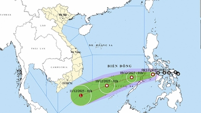
According to the National Center for Hydro-Meteorological Forecasting, as of 2:00 p.m. today (December 7), the center of the tropical depression was still over the central region of the Philippines. The strongest wind near the center of the tropical depression was level 6 (39-49 km/h), gusting to level 8.
The tropical depression continues to move west at a speed of about 15km/h.

In the next 24 hours, the tropical depression will change direction, moving to the West Southwest, at a speed of 15-20 km/h. By 2:00 p.m. tomorrow (December 8), the center of the tropical depression will be in the area east of Palawan Island (Philippines) with an intensity of level 6, gusting to level 8.
24 hours later, the tropical depression maintained its direction of movement, moving faster at about 20km/h and entering the East Sea. At 2:00 p.m. on December 9, the center of the tropical depression was in the northern area of Truong Sa special zone, about 140km east-southeast of Song Tu Tay island. The intensity of the tropical depression was currently maintained at level 6, gusting to level 8.
From the next 48 to 72 hours, the tropical depression will continue to move in the West Southwest direction, traveling 20-25km per hour, gradually weakening in intensity.
Thus, after entering the East Sea, the tropical depression will still maintain its level 6 intensity, gusting to level 8, and is unlikely to strengthen into a storm as previously forecast.
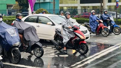
Due to the influence of the tropical depression, from the morning of December 8, the sea area southeast of the central East Sea (including the sea area northeast of Truong Sa special zone) has wind level 6, gust level 8, waves 2-4m, rough sea. Ships operating in the above-mentioned dangerous area are likely to be affected by storms, whirlwinds, strong winds, and big waves.
Source: https://baolaocai.vn/ap-thap-nhiet-doi-sap-doi-huong-dien-bien-bat-ngo-khi-vao-bien-dong-post888403.html


Comment (0)