
Flexible approach
These days, the atmosphere in Nhan Hoa ward is one of intense activity. As a unit formed by the merger of three former localities, the ward has nearly 4,000 land plot records to collect, resulting in a massive workload. Mr. Nguyen Thanh Trung, Vice Chairman of the Ward People's Committee, said that the locality has mobilized all its resources, dividing the work into two phases to avoid overlap. The ward has established two working groups, enlisting officials who previously worked in the former communes and wards to leverage their local knowledge and familiar relationships with the people, helping to shorten the process and reduce the workload after the merger.
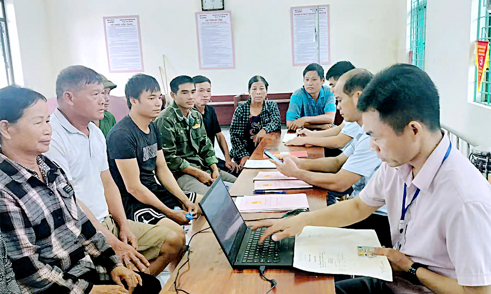 |
Officials in Kien Lao commune are collecting data on residential land owned by local residents. |
Ms. Dao Thi Bich (born in 1941, Cong Coi neighborhood) shared: “I heard the announcement to bring documents to the village cultural center to update land data, but my leg hurt so I couldn't go. I'm so happy that officials came to my house to help update my records, synchronize information, and ensure the rights of the people.”
The "door-to-door" approach has made collecting records more efficient and fostered a sense of community responsibility. After more than a month of implementation, specialized agencies have proactively cross-checked data from specialized systems, clearly identifying discrepancies and inconsistencies. The current requirement is to update data to be "accurate, complete, clean, and relevant," truthfully reflecting both the person named on the land use right certificate and the person directly using the land.
Not only in Nhan Hoa, the campaign to clean up and enrich land data is also being vigorously implemented in Kien Lao commune (formed from the former Kien Lao and Kien Thanh communes). The commune People's Committee was assigned to collect and update data for 1,778 land parcels. Immediately upon launching the campaign, the commune established a working group to collect and verify information. A comprehensive communication campaign was implemented to help people understand the information promptly and actively cooperate. People could bring original documents for officials to photograph, submit photocopies, or send photos via Zalo. As a result, by mid-October, Kien Lao commune had collected information on 3,006 land parcels, of which 628 were cleaned up and 2,378 were enriched, achieving 169% of the target.
Many other localities are also implementing a synchronized and scientific approach, assigning responsibility to each group and individual for specific results. A new initiative is encouraging people to use the CamScanner application to photograph documents, resulting in clearer images, more accurate data display, and reduced data entry errors – a small but significant step in the digital transformation process of rural areas.
Mobilize the entire political system to participate.
According to the Department of Agriculture and Environment, the province has over 572,500 land users, of which nearly 500,000 cases have had their data updated and standardized, while approximately 23,000 cases have not yet been matched and nearly 50,000 cases remain unidentified. Authorities have extracted over 266,510 pieces of information on land parcels, houses, and land users, sending them to communes and wards to collect land use right certificates and citizen identification cards of the owners.
To date, localities have collected and scanned more than 131,500 land use right certificates. The Bac Ninh Land Registration Office has received nearly 55,000 image files sent by communes and updated forms for nearly 31,000 land parcels. These figures demonstrate the significant efforts of the entire system. Information security and cybersecurity are emphasized during the data collection and storage process.
However, some areas still face difficulties due to a lack of specific information about landowners, subdivided plots, or users who do not reside locally. Some communes and wards affected by the floods following Typhoon No. 11 also caused delays in implementation. The process of verifying data and supplementing people's information has not been smooth, especially in specific cases such as land certificates being mortgaged, lost, torn, or landowners living far away.
During the implementation process, some residents reported being asked to photocopy and notarize their documents. Local leaders explained that because information on land users is compiled over different periods, and there are changes between identity cards and citizen identification cards, providing photocopies of documents is necessary for accurate data entry (not requiring notarization). Due to the large workload and the fact that specialized staff are handling multiple tasks, residents were asked to photocopy their documents (without notarization) for data entry outside of working hours, but the wording could be misinterpreted, leading to unnecessary negative reactions.
Mr. Hoang Hai Lam, Director of the Bac Ninh Land Registration Office No. 1, affirmed: “People only need to provide a copy of their Land Use Right Certificate and citizen identification card when requested, without notarization. For certificates that are mortgaged, lost, torn, or where the landowner lives far away, they only need to clearly state the status as “mortgaged” and provide a photo or copy; all data has been stored in the industry's system. After collection, people can check and verify the information on the National Population Database through the VNeID application, ensuring transparency and convenience.”
The leaders of the Department of Agriculture and Environment emphasized that the management agency cannot review everything, therefore the cooperation of the people is needed, both those whose names are on the land certificates and those who actually use the land. For the 90-day campaign to "enrich and clean" land data to be effective, localities must mobilize the entire political system and choose methods appropriate to the actual situation.
In the future, when the self-declaration software for land data is integrated into the VNeID application, people will be able to take photos, scan, and send information online themselves; aiming towards a unified, transparent, and interconnected land database - effectively serving state management and the needs of the people.
The "digitization" of land data is not just about cleaning up information, but also about innovating governance thinking, putting the people at the center. When data is digitized, Bac Ninh will have a solid foundation to break through in its journey to build a digital government, digital economy, and a transparent, connected digital society.
Source: https://baobacninhtv.vn/bac-ninh-tang-toc-so-hoa-du-lieu-dat-dai-postid429966.bbg


![[Photo] New recruits happily exercise their right to vote at their unit.](https://vphoto.vietnam.vn/thumb/1200x675/vietnam/resource/IMAGE/2026/03/14/1773473286544_stug0337-6388-jpg.webp)


Comment (0)