

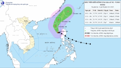
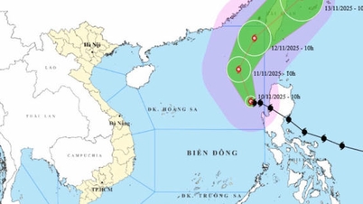
The National Center for Hydro-Meteorological Forecasting informed that early this morning, November 10, storm Fung-wong entered the eastern sea of the North East Sea, becoming storm number 14 in 2025.
At 7:00 a.m. on November 10, the center of the storm was located at approximately 17.4 degrees North latitude - 119.2 degrees East longitude, in the eastern sea of the North East Sea. The strongest wind near the center of the storm was level 13 (134-149 km/h), gusting to level 16. The storm was moving in a West Northwest direction at a speed of approximately 15 km/h.
The National Center for Hydro-Meteorological Forecasting predicts that by the morning of November 11, the storm's center will be in the eastern sea of the North East Sea, level 13, gusting to level 16, and moving northwest at about 10-15km/hour.
By the morning of November 12, the storm center was in the northeastern sea of the North East Sea, level 13, gusting to level 16, and changing direction to the North Northeast at a speed of about 10-15km/hour.
By the morning of November 13, the storm's center was located on the northeastern coastal area of Taiwan (China), down to level 8, gusting to level 10 and moving northeast at a speed of about 15-20km/hour.
The National Center for Hydro-Meteorological Forecasting warns that due to the impact of the storm, today, the eastern sea area of the North East Sea will have strong winds of level 8-10; the area near the eye of the storm will have strong winds of level 11-13, gusts of level 16, waves of 5-8m high, the area near the eye of the storm will have waves of 8-10m, and the sea will be very rough. All ships operating in the above-mentioned dangerous areas are likely to be affected by storms, whirlwinds, strong winds, and large waves.
Source: https://www.sggp.org.vn/bao-fung-wong-vao-bien-dong-lien-tuc-doi-huong-post822706.html


![[Photo] Prime Minister Pham Minh Chinh attends the Patriotic Emulation Congress of the Ministry of Foreign Affairs for the 2025-2030 period](https://vphoto.vietnam.vn/thumb/1200x675/vietnam/resource/IMAGE/2025/11/10/1762762603245_dsc-1428-jpg.webp)
![[Photo] Prime Minister Pham Minh Chinh attends the annual Vietnam Business Forum](https://vphoto.vietnam.vn/thumb/1200x675/vietnam/resource/IMAGE/2025/11/10/1762780307172_dsc-1710-jpg.webp)


![Dong Nai OCOP transition: [Article 3] Linking tourism with OCOP product consumption](https://vphoto.vietnam.vn/thumb/402x226/vietnam/resource/IMAGE/2025/11/10/1762739199309_1324-2740-7_n-162543_981.jpeg)


Comment (0)