
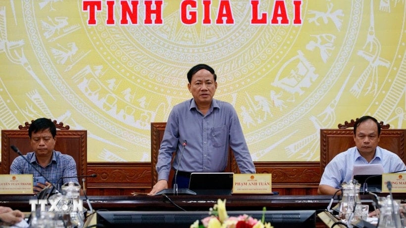
On November 2, the Chairman of the Gia Lai Provincial People's Committee chaired an urgent meeting with departments, branches, sectors and 58 communes and wards in the eastern region of the province on preparations to respond to storm Kalmaegi.
Chairman of the Provincial People's Committee Pham Anh Tuan said that the storm is forecast to have a direct impact and Gia Lai is likely to be in the eye of the storm.
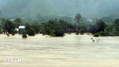
The Chairman of the Gia Lai Provincial People's Committee warned that the storm could cause major flooding, even exceeding historical levels (1.5 times higher) than the biggest flood in the old Binh Dinh. There is a risk of serious landslides and flash floods due to the steep slope of the area; while deep flooding in the delta areas is also a concern.
The Chairman of the Gia Lai Provincial People's Committee also expressed concern that, after many years without major storms and floods, the political system may be subjective in responding to and preventing natural disasters.
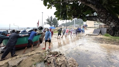
Faced with this situation, the Chairman of the Provincial People's Committee requested that localities must proactively implement the principle of storm prevention; prevent early, from afar, and upgrade storm response. First of all, it is necessary to resolutely evacuate people in landslide and flooded areas to safe places, and wait until the situation is stable before returning.
If the wards/communes do not evacuate their people and an accident occurs, the province will definitely take strict disciplinary action and remove the Secretary and Chairman from office. All accommodation and living expenses during the evacuation period (expected to be two to three days) will be supported by the provincial budget, and the people will not have to bear any expenses.
Regarding the 4 on-site readiness work, the Chairman of the Provincial People's Committee requested to change food and provisions; prioritize items such as: dry food, cakes, cereals, bottled water, etc. On-site means need to focus on water vehicles (boats), have fuel ready; have people on duty in each commune and each area so that when necessary, they can mobilize and coordinate timely rescue.
Chairman of the Provincial People's Committee Pham Anh Tuan also requested the Military Command and localities to increase the use of drones to conduct reconnaissance flights to check the flood situation if an incident occurs; and at the same time, purchase 2 UAVs (unmanned cargo transport devices) to serve the rescue work.
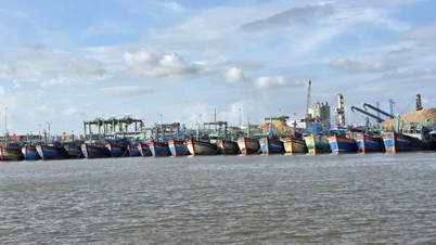
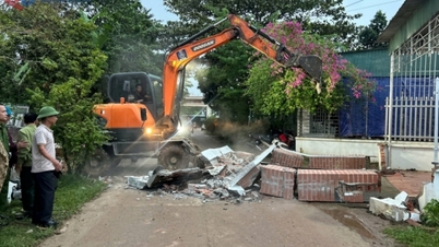
At the same time, the Chairman of the Provincial People's Committee also requested localities to mobilize all forces to harvest rice and crops, and have plans to protect aquaculture cages before the storm hits. The Provincial Police must immediately deploy support plans; ensure security, order, and property for people when they evacuate.
According to forecast sources, the storm is likely to cause strong winds on the sea and land of Gia Lai province. The Department of Agriculture and Environment also proposed activating a scenario to respond to level 10 storm winds.
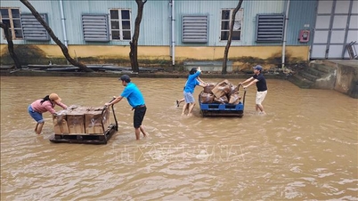
Gia Lai province is expected to evacuate 7,011 households/24,542 people in 50 communes and wards in the eastern part of the province in a mixed manner and 950 households/3,313 people in 38 communes and wards in the eastern part of the province in a concentrated manner. The evacuation will be implemented and completed before 4:00 p.m. on November 5, 2025.
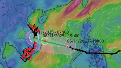
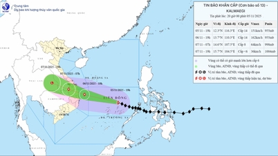
According to the National Center for Hydro-Meteorological Forecasting, storm Kalmaegi is currently in the sea east of the central Philippines and is likely to strengthen.
At 7:00 p.m. on November 2, the center of storm Kalmaegi was at about 11.3 degrees North latitude; 131.2 degrees East longitude, in the sea east of the central Philippines. The strongest wind near the center of the storm was level 10 (89-102 km/h), up 1 level; gusting to level 13, up 2 levels compared to 4:00 p.m. the same day. The storm moved westward at a fast speed of about 30-35 km/h.
At 7:00 p.m. on November 3, the storm in the sea east of the central Philippines with strong winds of level 12, gusts of level 15, moving mainly west at a speed of about 20km/h and likely to strengthen.
As of 7 p.m. on November 4, the storm in the western central Philippines with strong winds of level 12, gusts of level 15, was moving mainly in the West Northwest direction at a speed of about 20-25 km/h. The affected area is the sea area east of the central East Sea. Disaster risk level 3.
As of 7 p.m. on November 5, the storm was in the central East Sea with winds of level 13, gusts of level 17, moving west-northwest at a speed of about 15-20 km/h and likely to intensify. The affected area is the central East Sea (including Truong Sa special zone). Disaster risk level 3.
From the next 72 to 120 hours, the storm will move mainly in the West-Northwest direction, about 20-25km per hour and will likely strengthen.
Due to the impact of the storm, from around the afternoon of November 4, the sea area east of the central East Sea will have winds gradually increasing to level 6-7, then increasing to level 8-9; the area near the storm center will have strong winds of level 10-12, gusts of level 14-15, waves 5-7m high, and rough seas.
The National Center for Hydro-Meteorological Forecasting warns that between November 5 and 6, the Central East Sea area (including Truong Sa special zone), the sea off the coast of Da Nang - Khanh Hoa area may be affected by strong winds of level 12 - 14, gusts above level 17, waves 8-10m high, and rough seas.
All ships and structures operating in the above-mentioned dangerous areas are strongly affected by storms, whirlwinds, strong winds and big waves.
Source: https://baohaiphong.vn/bao-kalmaegi-co-kha-nang-manh-len-gia-lai-hop-khan-ban-bien-phap-doi-pho-voi-bao-525419.html
![[Photo] Opening of the 14th Conference of the 13th Party Central Committee](https://vphoto.vietnam.vn/thumb/1200x675/vietnam/resource/IMAGE/2025/11/05/1762310995216_a5-bnd-5742-5255-jpg.webp)


![[Photo] Panorama of the Patriotic Emulation Congress of Nhan Dan Newspaper for the period 2025-2030](https://vphoto.vietnam.vn/thumb/1200x675/vietnam/resource/IMAGE/2025/11/04/1762252775462_ndo_br_dhthiduayeuncbaond-6125-jpg.webp)


![[Motion Graphics] 5 notes when converting from lump-sum tax to declaration](https://vphoto.vietnam.vn/thumb/402x226/vietnam/resource/IMAGE/2025/11/06/1762381214740_fb_thoi-tiet-cms-1200x800-3.jpeg)


Comment (0)