
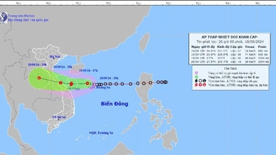
According to the National Center for Hydro-Meteorological Forecasting, at 7:00 AM on October 7th, the typhoon's center was located at approximately 21.1 degrees North latitude and 115.4 degrees East longitude, about 180km southeast of Hong Kong (China). The strongest winds near the center of the typhoon reached level 13 (134-149 km/h), with gusts up to level 16, and it was moving slowly westward at a speed of about 5 km/h.
Forecasts indicate that by 7:00 AM on October 8th, Typhoon No. 4 will be approximately 140km south of Hong Kong (China), with maximum wind speeds near the center reaching level 12, gusting to level 15, and moving westward at a speed of about 5km/h.
By 7:00 AM on October 9th, the storm was approximately 230km southwest of Hong Kong (China), with maximum sustained winds near the center reaching levels 9-10, gusting to level 13. It was moving west-southwest at about 5km per hour and gradually weakening.
By 7:00 AM on October 10th, the storm, located off the eastern coast of the Leizhou Peninsula (China), had maximum wind speeds near its center reaching level 8, with gusts up to level 10. It continued to move west-southwest at a speed of approximately 10 km/h and continued to weaken.
Over the next 72 to 96 hours, the storm moved mainly west-southwest at about 10 km per hour, weakening into a tropical depression and then into a low-pressure area.
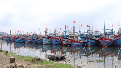
The National Center for Hydro-Meteorological Forecasting stated that over the next 24 to 48 hours, the northern part of the South China Sea will experience strong winds of force 7-10, with winds near the storm's center reaching force 11-13, gusting to force 16; the sea will be extremely rough. All vessels operating in this area will be affected by the strong winds. Wave heights in the North China Sea will be 2-4 meters, with waves reaching 4-6 meters in the northern part and 7-9 meters near the storm's center.
Source


![[Photo] Prime Minister Pham Minh Chinh holds a phone call with the CEO of Russia's Rosatom Corporation.](/_next/image?url=https%3A%2F%2Fvphoto.vietnam.vn%2Fthumb%2F1200x675%2Fvietnam%2Fresource%2FIMAGE%2F2025%2F12%2F11%2F1765464552365_dsc-5295-jpg.webp&w=3840&q=75)


Comment (0)