
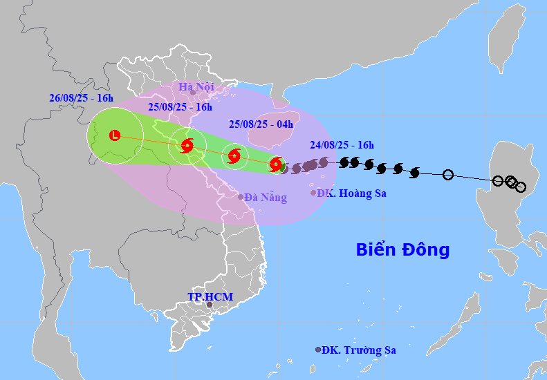
The forecast for the next 3 hours is that the storm will move in a west-northwest direction at a speed of approximately 15 km/h.
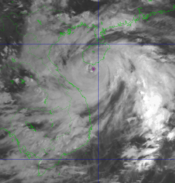
As of 4:00 AM on August 25th, the center of Typhoon No. 5 was located at approximately 18 degrees North latitude and 107.9 degrees East longitude in the southern part of the Gulf of Tonkin (about 240km east of Nghe An, 210km east of Ha Tinh , and 140km east of northern Quang Tri) with maximum wind speeds of level 13-14, gusting to level 16.
The storm continues to move west-northwest at a speed of 20 km/hour. By 4 PM on August 25th, the center of Typhoon No. 5 was located at approximately 18.5 degrees North latitude and 105.6 degrees East longitude, over land between Thanh Hoa and Quang Tri provinces, with maximum wind speeds of level 11-12, gusting to level 14.
Level 4 natural disaster risk applies to coastal areas from Thanh Hoa to Quang Tri and inland areas from Thanh Hoa to northern Quang Tri; level 3 applies to the northern East Sea, the Gulf of Tonkin, and the sea area south of Quang Tri to Hue.
Typhoon No. 5 continues to move further inland in a west-northwest direction and gradually weakens.
Due to the influence of the storm, the sea area from Thanh Hoa to Hue will experience strong winds of level 7-9, later increasing to level 10-11, with winds near the storm's center reaching level 12-14 and gusts up to level 16; sea waves will be 5-7m high, with waves near the storm's center reaching 8-10m.
On land from Thanh Hoa to Quang Tri, there will be strong winds of level 8-10, with winds near the storm's center reaching level 11-13 and gusts of level 14-15; coastal areas from Quang Ninh to Ninh Binh will experience winds of level 6-8, with gusts of level 9.
From August 24th to 26th, the area from Thanh Hoa to northern Quang Tri will experience very heavy rainfall with amounts ranging from 200-400mm, locally exceeding 700mm, and the risk of rainfall exceeding 200mm in 3 hours.
According to the Central Vietnam Meteorological and Hydrological Station's forecast, the sea area around Da Nang city will experience increasingly strong winds, reaching levels 6-7, gusting to levels 8-9, with rough seas and waves 2-4 meters high.
Due to the influence of the western edge of the circulation of typhoon No. 5, from August 24 to 26, Da Nang city will experience showers and thunderstorms, with localized moderate to heavy rain; during thunderstorms, be wary of tornadoes and lightning.
Rainfall was concentrated on August 24-25, then gradually decreased. The total rainfall for the entire period in the communes and wards ranged from 40-100mm, with some areas exceeding 130mm; specifically, the communes and wards in the southern delta region received 30-60mm, with some areas exceeding 80mm.
Source: https://baodanang.vn/bao-so-5-gay-gio-manh-mua-rat-to-tu-thanh-hoa-den-quang-tri-3300218.html

![[Photo] Prime Minister Pham Minh Chinh holds a phone call with the CEO of Russia's Rosatom Corporation.](/_next/image?url=https%3A%2F%2Fvphoto.vietnam.vn%2Fthumb%2F1200x675%2Fvietnam%2Fresource%2FIMAGE%2F2025%2F12%2F11%2F1765464552365_dsc-5295-jpg.webp&w=3840&q=75)


![[Infographic] Preventing students from making their own firecrackers: 7 things parents need to know](https://vphoto.vietnam.vn/thumb/402x226/vietnam/resource/IMAGE/2025/12/11/1765466656703_img_0320_20251211183542.jpeg)


Comment (0)