
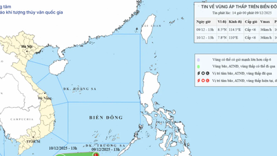
According to the National Center for Hydro-Meteorological Forecasting, on the morning of September 6th, a tropical depression was active in the eastern part of the North East Sea, with a strength of level 7. The current conditions for the development of this tropical depression are quite favorable, with sea surface temperatures in the northern part of the South China Sea, above 15 degrees North latitude, currently at 29-30 degrees Celsius.
Within the tropical depression's area of activity, the wind shear is also small, coupled with relatively strong southwest winds in the south, therefore the probability of this tropical depression strengthening into a typhoon is as high as 70-80%. It is forecast that this tropical depression will strengthen into a typhoon this evening and tonight. If it strengthens into a typhoon, it will be the 16th typhoon in the Northwest Pacific region and the 7th typhoon operating in the South China Sea, and according to the international list, its name will be Tapah.
This tropical depression/storm formed in the northern part of the South China Sea, while the subtropical high-pressure ridge, which is the dominant shape determining the path and direction of tropical depressions/storms, tends to weaken. This tropical depression/storm is located in the western part of the subtropical high-pressure ridge. Following its path, the storm will mainly move northwest. With a northwest direction, the likelihood of the storm moving far towards the Vietnamese mainland is low; instead, it is more likely to make landfall in mainland China.
 |
| Expected path of the tropical depression. (Photo: KTTV) |
Currently, forecasts from international storm forecasting centers predict that this storm will make landfall in China's Guangdong province on September 8, next Monday. When it makes landfall, the storm's intensity could reach level 10-11, gusting to level 13-14.
Vietnam's forecast is quite similar to international forecasts. Vietnam predicts that during the evening and night of September 6th, this tropical depression will strengthen into a typhoon (Typhoon No. 7), reaching its strongest intensity when approaching the mainland coast of Guangdong province (China), with gusts up to level 10, and making landfall in mainland China around the morning and noon of September 8th, which is the morning and noon of next Monday.
The National Center for Meteorological and Hydrological Forecasting further reported that this storm formed on the tropical convergence zone. Its formation location was in the northern part of the South China Sea; however, the storm's formation point was quite high, in the northern part of the South China Sea, and its direction of movement deviated significantly northward. While storms typically affect Northern Vietnam, this one instead made landfall in China.
Although it made landfall in China, Typhoon No. 7 will quickly weaken into a low-pressure area after landfall, then drift westward towards Vietnam. It is likely that from the afternoon and night of September 9-11, the post-typhoon circulation will cause widespread heavy rain in Northern Vietnam, with the heaviest rainfall concentrated in the midland and mountainous areas of the Northeast.
Source: https://baolamdong.vn/bao-so-7-chuan-bi-do-bo-chuyen-gia-du-bao-mua-lon-o-bac-bo-trung-bo-390278.html


![[Photo] Urgently help people soon have a place to live and stabilize their lives](/_next/image?url=https%3A%2F%2Fvphoto.vietnam.vn%2Fthumb%2F1200x675%2Fvietnam%2Fresource%2FIMAGE%2F2025%2F12%2F09%2F1765248230297_c-jpg.webp&w=3840&q=75)


Comment (0)