
According to Mr. Hoang Duc Cuong, Deputy Director of the National Hydrometeorological Forecasting Department, storm No. 16, after forming in the East Sea, will be very unpredictable due to interaction with cold air.
Today (December 4), a tropical depression exists in the eastern sea of the central Philippines. It is forecasted that around December 6-7, this tropical depression will likely pass through the central Philippines into the East Sea, possibly strengthening into storm No. 16.
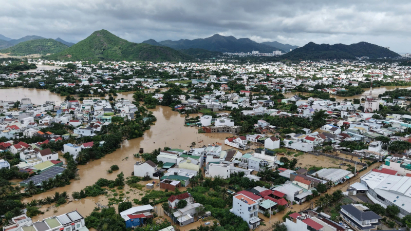
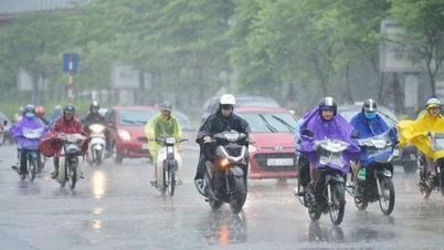
Early assessments show that this storm is likely to directly affect the mainland of the Central and South Central regions, causing moderate to heavy rain in the provinces from Hue to Khanh Hoa . This is also the area that has just experienced a historic flood.
Currently, this area is also experiencing heavy rain since December 2, counting from last night and this morning (December 4), the area from South Quang Tri to Da Nang , the east of the provinces from Quang Ngai to Dak Lak, Khanh Hoa and Lam Dong has moderate rain, heavy rain, and very heavy rain in some places. Some 180mm stations such as Ba Na station (Da Nang) 228.2mm, Khanh Hiep (Khanh Hoa) 196mm, Tra Nham (Quang Ngai) 189mm, Phan Dung (Lam Dong) 202.4mm.
It is forecasted that today and tonight, the area from South Quang Tri to Da Nang and the east of Quang Ngai province will have moderate to heavy rain of 40-80mm, with some places having very heavy rain over 120mm. The eastern area of Gia Lai, Dak Lak , Lam Dong, Khanh Hoa provinces and the Southeast region will have widespread rain from 20-40mm, with some places having heavy rain over 80mm.
It is forecasted that from December 5, heavy rains in the area from South Quang Tri to Da Nang and the east of Quang Ngai province will gradually decrease. Further assessment, in December 2025, in the East Sea area, there is a possibility of 1-2 storms/tropical depressions appearing.
Also in December 2025, the Central and South Central regions are likely to experience 1-2 widespread moderate and heavy rains, in which rainfall in the area from South Quang Tri to the northern part of the South Central Coast tends to be higher than the average of many years, so it is necessary to guard against the risk of flash floods and landslides.
Vietnam is experiencing a historic storm season. By the end of November 2025, there had been 21 storms/tropical depressions (15 storms, 6 tropical depressions) active in the East Sea, making it the year with the highest number of storms/tropical depressions active in the East Sea since observation data began (since 1961), the previous highest year being 2017 with 20 storms/tropical depressions (16 storms, 4 tropical depressions).
In addition to the record number of storms/tropical low pressure areas, the 2025 storm season also recorded a number of special, unusual and extreme characteristics. Storm No. 1 (WUTIP) was the first storm to appear in the East Sea in June after more than 40 years. Storm No. 9 (RAGASA) with a strong intensity of level 17, gusting above level 17, became the strongest storm ever active in the East Sea area.
According to the National Center for Hydro-Meteorological Forecasting, in December 2025, cold air will continue to increase in frequency and intensity, and severe cold may appear in the North, concentrated in the northern mountainous areas. Cold air will continue to be active in January and February 2026, causing severe cold spells.
Source: https://cand.com.vn/Xa-hoi/bien-dong-chuan-bi-don-bao-so-16-i790057/

![[Photo] Cat Ba - Green island paradise](/_next/image?url=https%3A%2F%2Fvphoto.vietnam.vn%2Fthumb%2F1200x675%2Fvietnam%2Fresource%2FIMAGE%2F2025%2F12%2F04%2F1764821844074_ndo_br_1-dcbthienduongxanh638-jpg.webp&w=3840&q=75)


![[VIMC 40 days of lightning speed] Da Nang Port: Unity - Lightning speed - Breakthrough to the finish line](https://vphoto.vietnam.vn/thumb/402x226/vietnam/resource/IMAGE/2025/12/04/1764833540882_cdn_4-12-25.jpeg)


Comment (0)