
 |
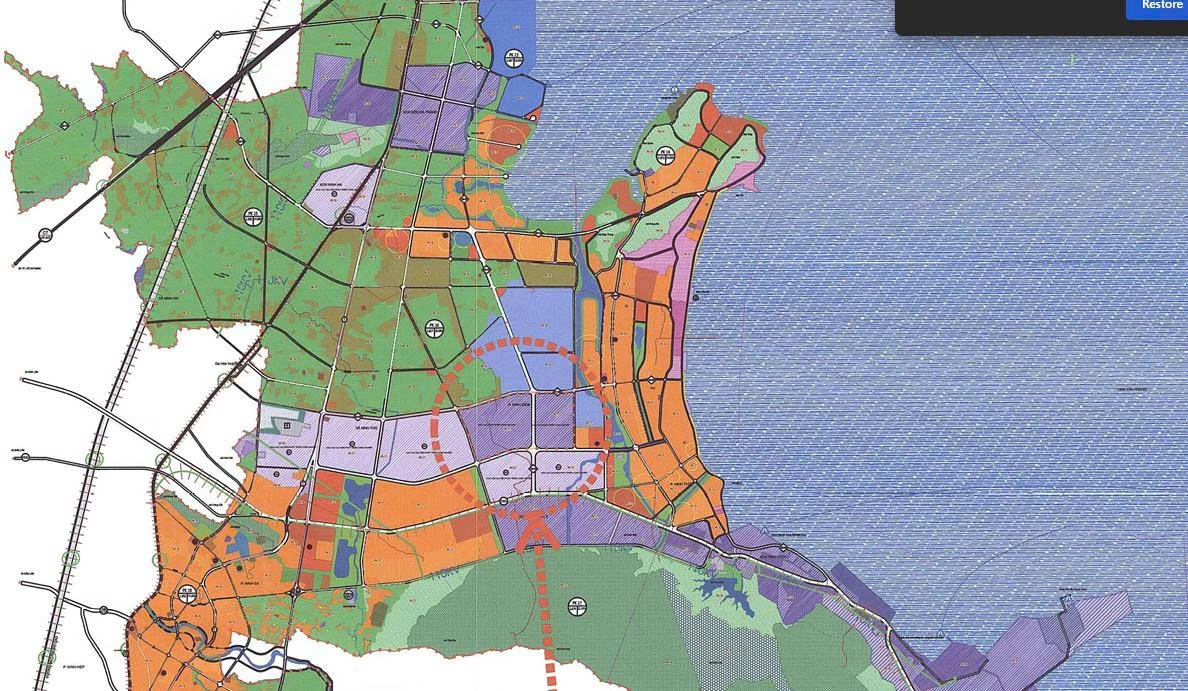
| Local Adjustment Map of Subdivision 17. |
According to the decision, the scope of adjustment belongs to Sub-zone 17, the north borders Sub-zone 16 and Provincial Road 1A; the south borders the long-term planning industrial park; the east borders Sub-zone 14; the west borders the urban functional area of Sub-zone 17 (South Van Phong area). The scale of the adjusted area is about 248 hectares, accounting for 0.16% of the total area of the General Planning of Van Phong Economic Zone approved by the Prime Minister. After adjustment, the industrial land of the whole area increased from 2,721 hectares to 2,969 hectares (an increase of 248 hectares). This additional area is synchronously updated in the drawing records, land use indicators and Management Regulations according to the general planning project.
The Provincial People's Committee assigned the Provincial Economic Zone and Industrial Zone Management Board to fully publicize the adjusted content; review lower-level plans to ensure consistency and avoid overlap; and develop a plan to implement the plan in conjunction with investment in technical infrastructure. This unit is also required to prepare resettlement land funds according to the principle of transparency, ensuring that "people in the new place of residence have a life equal to or better than the old place of residence". The Department of Construction and relevant agencies are responsible for updating the adjusted content into sectoral and zoning plans; inspecting and guiding the implementation, while ensuring the connection and synchronization between the approved plan and this local adjustment.
MANH HUNG
Source: https://baokhanhhoa.vn/xa-hoi/202512/dieu-chinh-cuc-bo-quy-hoach-chung-khu-kinh-te-van-phong-9bf6c7c/

![[Photo] Cat Ba - Green island paradise](/_next/image?url=https%3A%2F%2Fvphoto.vietnam.vn%2Fthumb%2F1200x675%2Fvietnam%2Fresource%2FIMAGE%2F2025%2F12%2F04%2F1764821844074_ndo_br_1-dcbthienduongxanh638-jpg.webp&w=3840&q=75)


![[VIMC 40 days of lightning speed] Da Nang Port: Unity - Lightning speed - Breakthrough to the finish line](https://vphoto.vietnam.vn/thumb/402x226/vietnam/resource/IMAGE/2025/12/04/1764833540882_cdn_4-12-25.jpeg)


Comment (0)