
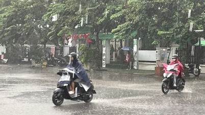
According to the National Center for Hydro-Meteorological Forecasting, this morning, November 2, cold air from the northern continent is moving south. Hanoi and many places in the North will have cold weather and continued drizzle.
The meteorological agency said that around noon and afternoon this morning, this cold air mass will affect the Northeast region, then expand to the Northwest, North Central and part of the Central Central region.

From tonight to November 4, the North will turn cold, with some mountainous areas experiencing severe cold, with the lowest temperature commonly ranging from 16-19 degrees Celsius, and in highland areas below 15 degrees Celsius. Northeast winds of level 3-4 will appear in coastal areas. Cold weather will spread throughout the North.
After the North is deep in the center of the cold air mass, the rain will decrease and gradually dry.
However, in the process of moving deeper into the Central region, the old cold air layers and the strengthened cold air combined with high-altitude easterly wind disturbances are and will continue to cause widespread heavy rain in the Central region.
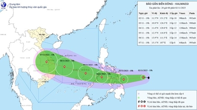
 held a meeting on flood forecast on November 1. Photo: Department of Hydrometeorology")
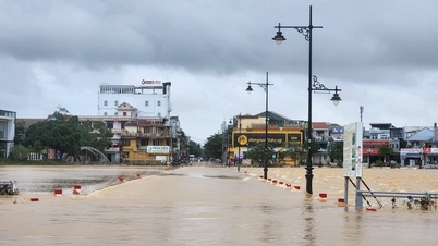
Compared to yesterday's forecast, November 1, by the National Center for Hydro-Meteorological Forecasting, today's rainy area has expanded, covering from Ha Tinh to Quang Ngai, many places will have heavy rain with a total amount of 300-500mm, some places over 750mm on November 2 and 3.
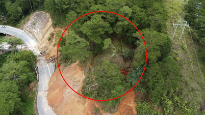
Localities such as Quang Tri, Hue, Da Nang and the eastern region of Quang Ngai province are the focus of rain, wind and bad weather (high risk of flooding, flash floods and landslides, natural disaster risk level reaches level 2).

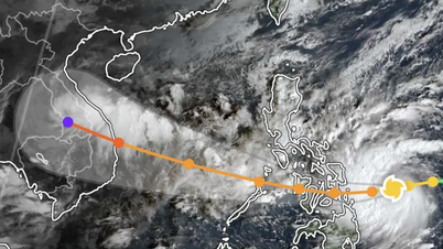
From November 5, rain and wind in the Central region tend to gradually decrease in intensity, but then a new wave of rain and floods may appear due to the impact of storm No. 13 (according to the long-term forecast of the National Center for Hydro-Meteorological Forecasting).
In the Central Highlands today there will also be heavy rain, rainfall can exceed 150mm in 3 hours, while the East of Dak Lak, Lam Dong and the South will continue to have showers and thunderstorms, with the possibility of tornadoes, lightning, and strong gusts of wind.

The meteorological agency also added that the rain in the Central Highlands and the South is not directly caused by cold air, but by the disturbance of the East wind above and the strong activity of the Intertropical Convergence Zone (ITCZ), combined with humidity spreading from the Central region to the South.
The reason is that when the cold air mass strengthens in the Central region, it will push the tropical convergence zone back to the South, causing thunderstorms and humidity to expand in the Central Highlands and the South.
Accordingly, in the evening and night of November 2 and 3, the South will have showers, with some places experiencing heavy rain of over 70mm, concentrated in coastal areas from the East of Ho Chi Minh City to Ca Mau province.
Meteorological experts have advised people in the Central and Central Highlands regions to proactively prepare for natural disasters and dangerous weather when heavy rain coincides with the strengthening cold air. At the same time, people in the North are preparing to welcome the most obvious cold spell since mid-October 19, opening the winter of 2025-2026.
Source: https://www.sggp.org.vn/hom-nay-2-11-nhieu-noi-mua-do-thoi-tiet-xau-post821293.html

![[Photo] President Luong Cuong receives US Secretary of War Pete Hegseth](https://vphoto.vietnam.vn/thumb/1200x675/vietnam/resource/IMAGE/2025/11/02/1762089839868_ndo_br_1-jpg.webp)


![[Photo] Lam Dong: Images of damage after a suspected lake burst in Tuy Phong](https://vphoto.vietnam.vn/thumb/1200x675/vietnam/resource/IMAGE/2025/11/02/1762078736805_8e7f5424f473782d2162-5118-jpg.webp)


Comment (0)