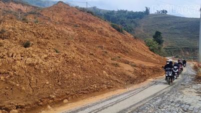
The Deputy Prime Minister requested the Ministry of National Defense to urgently implement a plan to use drones to inspect, survey, and detect large cracks in areas at risk of landslides due to heavy and prolonged rainfall.
Maintain smooth communication and operational control.
On the morning of October 27th, at the Government's Information and Steering Center, Prime Minister and Deputy Prime Minister Tran Hong Ha held an online meeting with provinces from Ha Tinh to Quang Ngai and Kon Tum province regarding the response to Typhoon No. 6 (Typhoon Trami), which is expected to make landfall in southern Quang Tri and northern Quang Nam at noon on October 27th.
Concluding the meeting, Deputy Prime Minister Tran Hong Ha highly appreciated the preparations for responding to Typhoon No. 6 in the central provinces, noting that they were proactive, systematic, and at the highest level.

Deputy Prime Minister Tran Hong Ha delivers concluding remarks at the meeting (Photo: VGP).
Given the complex developments of Typhoon No. 6, which, after making landfall, will turn back out to sea and may form a low-pressure system or a new typhoon, the Deputy Prime Minister requested that the meteorological and hydrological system accurately forecast the time of landfall and identify vulnerable coastal dykes so that forces and resources can be concentrated to handle any incidents promptly.
In addition, with heavy and prolonged rainfall, meteorological and hydrological stations continue to update rainfall data and issue more specific warnings to people about areas at risk of landslides.
The Ministry of National Defence is coordinating with and supporting local authorities to urgently implement plans using drones to inspect, survey, and detect large, long cracks in areas at risk of landslides due to heavy and prolonged rainfall.
The Deputy Prime Minister also instructed the Ministry of Agriculture and Rural Development (MARD), the Ministry of Industry and Trade, and the Ministry of Natural Resources and Environment (MONRE) to closely monitor water flow in reservoirs, supplement forecasts from the national meteorological and hydrological agency and local meteorological and hydrological stations to ensure timely regulation.
"We must not allow a situation where all reservoirs have to release water to ensure safety," the Deputy Prime Minister instructed.

Representatives from the Ministry of National Defense report on the preparations of forces and resources to respond to Typhoon No. 6 (Photo: VGP/Minh Khoi).
The Ministry of Transport, the Ministry of Information and Communications, and electricity and telecommunications companies are working closely with local authorities to maintain transportation, communication, and information connectivity, ensuring smooth management and operation.
The Deputy Prime Minister instructed the meteorological and hydrological agencies to closely forecast the timing of Typhoon No. 6's landfall and subsequent return to the sea.
The media promptly provided full, timely, and accurate information about the complex nature of Typhoon No. 6. Local leaders continued to pay close attention to the management of ships and boats at sea.
The period of strongest and most dangerous winds is from the morning of October 27th to the afternoon of October 27th.
Previously, according to the latest update from the National Center for Meteorological and Hydrological Forecasting, on the morning of October 27th, Typhoon No. 6 was located in the sea area south of Quang Tri - Da Nang.
Forecasts indicate that by noon on October 27th, Typhoon No. 6 will make landfall in the southern Quang Tri-Da Nang area. Near the center of the typhoon, winds will reach levels 8-9, with gusts up to level 11. Coastal areas of Quang Tri, Thua Thien Hue, and Da Nang will experience strong winds of levels 8-9, with gusts up to levels 10-11; further inland, winds may reach levels 6-7, with gusts up to levels 8-9.
The most dangerous period for strong winds is from the morning of October 27th to the afternoon of October 27th.

Overview of the meeting (Photo: VGP).
Over the next 12-24 hours, the storm moved eastward, reversing back out to sea, weakening into a tropical depression, then a low-pressure area, and finally dissipating.
Forecasts indicate that from the morning of October 27th to the end of October 29th, the Quang Binh-Quang Ngai area will continue to experience heavy rainfall of 200-400 mm, with some areas exceeding 600 mm. Southern Nghe An and Ha Tinh areas, as well as Quang Ngai and Kon Tum, will receive 150-250 mm of rain, with some areas exceeding 400 mm.
The northern areas of Nghe An and Gia Lai provinces received 50-100 mm of rain, with some places receiving over 150 mm.
The likelihood of flooding on rivers from Quang Tri to Quang Ngai is at level BĐ2-BĐ3, rivers in Quang Binh at level BĐ2, and rivers in Ha Tinh, Binh Dinh, and Kon Tum at level BĐ1.
From Quang Binh to Quang Ngai, there are over 30 districts and urban areas with 365 communes at risk of flooding.
The risk of flash floods and landslides is high to very high on steep hillsides and slopes in the area from southern Nghe An to Binh Dinh, Kon Tum and Gia Lai, especially from Quang Binh to Quang Nam.
Source: https://www.baogiaothong.vn/pho-thu-tuong-khan-truong-dung-flycam-ra-soat-phat-hien-vung-nguy-co-sat-lo-vi-bao-trami-192241027114336697.htm


Comment (0)