
In the Northeast region, the western part of Phu Tho province, and the eastern part of Son La province, there will be moderate to heavy rain and scattered thunderstorms, with rainfall generally ranging from 25 to 50mm, and in some localized areas exceeding 90mm.
On the afternoon and night of December 13th, the area from Thanh Hoa to Hue City experienced moderate to heavy rain with rainfall amounts generally ranging from 20 to 50mm, and in some localized areas exceeding 80mm.
Warning of the risk of heavy rainfall (>80mm/3h); thunderstorms may bring tornadoes, lightning, hail, and strong gusts of wind.
On the afternoon and night of December 13th, the area from Thanh Hoa to Hue City experienced rain, with rainfall generally ranging from 20 to 50mm, and locally exceeding 80mm.
On the night of December 13th, Da Nang City and the eastern part of Quang Ngai province experienced rain, with moderate to heavy rain; rainfall amounts were generally 10-20mm, and locally exceeding 40mm.
Warning: From December 14th, heavy rainfall in the above areas is expected to gradually decrease. Level of natural disaster risk due to heavy rain, tornadoes, lightning, and hail: Level 1.
Forecasts indicate the potential impact of heavy rainfall, including flooding in low-lying areas, urban areas, and industrial zones; flash floods on small rivers and streams; and landslides on slopes.
According to the National Center for Meteorological and Hydrological Forecasting, on the morning of December 13th, the eastern part of the North East Sea experienced strong northeasterly winds of force 6, gusting to force 7-8; rough seas with waves 2.0-4.0m high.
The sea area from Khanh Hoa to Ho Chi Minh City will experience strong northeasterly winds of force 5, sometimes force 6, with gusts of force 7-8; rough seas with waves 2.5-3.5m high.
From noon and afternoon of December 13th to the night of December 13th, the northern area of the East Sea (including the Hoang Sa special zone) will experience strong northeasterly winds of force 7-8, gusting to force 9-10; the sea will be rough, with waves 4.0-6.0m high.
During this time, in the Gulf of Tonkin, there will be strong northeasterly winds of force 6–7, sometimes force 8, gusting to force 9; the sea will be rough, with waves 2.0–4.0m high.
By late afternoon and night of December 13th, the sea area from southern Quang Tri to Ca Mau, the central East Sea and the western sea area of the southern East Sea (including the western sea area of the Truong Sa special zone) will experience strong northeasterly winds of force 6, sometimes force 7, gusting to force 8-9; rough seas, with waves 3.0-5.0m high.
Additionally, on December 13th, both day and night, scattered showers and thunderstorms are expected in the southern South China Sea (including the Spratly Islands), the sea area from Ca Mau to An Giang, and the southern part of the Gulf of Thailand.
On the afternoon and night of December 13th, the Gulf of Tonkin will experience scattered showers and thunderstorms; on the night of December 13th, the coastal waters from southern Quang Tri to Quang Ngai will have scattered showers and thunderstorms in some areas.
During thunderstorms, there is a possibility of tornadoes and strong gusts of wind.
According to the warning center, on the morning of December 14th, strong northeasterly winds of force 6, gusting to force 7-8, were observed in the Gulf of Tonkin; the sea was rough with waves 1.5-3.0m high; from the afternoon of December 14th, the wind intensity gradually decreased.
On December 14th, both day and night, the northern South China Sea (including the Hoang Sa Special Administrative Region) experienced strong northeasterly winds of force 7, occasionally reaching force 8 in the east, with gusts up to force 9; the sea was rough, with waves 4.0–6.0m high. In the western part of the northern South China Sea, winds gradually decreased from the night of December 14th.
The sea area from southern Quang Tri to Ca Mau, the central part of the East Sea, and the western part of the southern East Sea (including the western part of the Truong Sa special zone) will experience strong northeasterly winds of force 6, sometimes force 7, gusting to force 8-9; rough seas with waves 3.0-5.0m high. Specifically, the sea area from southern Quang Tri to Hue City and the central East Sea will gradually experience a decrease in wind speed from the night of December 14th.
All vessels operating in the aforementioned sea areas are at high risk of being affected by strong winds and high waves.
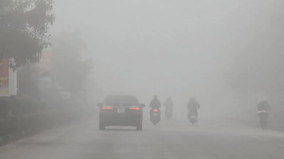
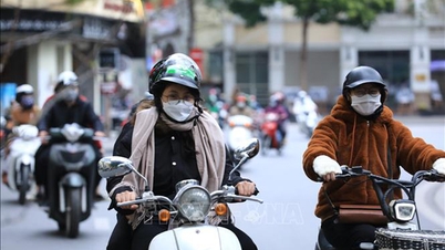
The weather across the country is as follows: Hanoi: Lowest temperature 14-16°C, highest temperature 20-22°C. Moderate to heavy rain and scattered thunderstorms during the day; scattered showers at night. Northeast winds gradually strengthen to level 3-4. Cold weather, with the possibility of tornadoes, lightning, hail, and strong gusts of wind during thunderstorms.
In the Northwest region, the lowest temperature will be 12-15 degrees Celsius, with some areas below 11 degrees Celsius, and the highest temperature will be 18-21 degrees Celsius, with some areas above 21 degrees Celsius. There will be showers and scattered thunderstorms during the day, with localized heavy rain. Specifically, the western part of Phu Tho province and the eastern part of Son La province will experience moderate to heavy rain and scattered thunderstorms, with localized very heavy rain. There will be scattered showers at night. The day will be cold, with some areas experiencing intense cold; the night will be intensely cold, with some areas experiencing severe cold. During thunderstorms, there is a possibility of tornadoes, lightning, hail, and strong gusts of wind.
In the Northeast region, the lowest temperature will be 13-16°C, 9-12°C in mountainous and midland areas, with some places below 5°C. The highest temperature will be 18-21°C, with some places above 21°C. Moderate to heavy rain and scattered thunderstorms are expected during the day, with localized very heavy rain; scattered showers are expected at night. Northeast winds will gradually strengthen to level 3-4, level 4-5 in coastal areas, and level 6 in some places, with gusts up to level 7-8. It will be cold, with some mountainous areas experiencing severe cold; particularly in mountainous and midland areas, it will be very cold at night, with some mountainous areas experiencing extreme cold. During thunderstorms, there is a possibility of tornadoes, lightning, hail, and strong gusts of wind.
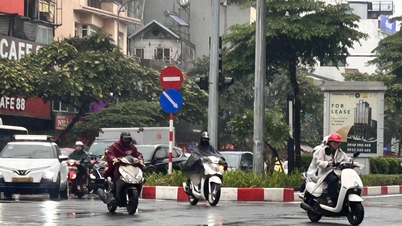
From Thanh Hoa to Hue, the lowest temperatures will be 14-17°C in the North and 18-20°C in the South. The highest temperatures will be 22-25°C, with some areas in the South exceeding 25°C. There will be scattered rain and showers in the morning; moderate to heavy rain and scattered thunderstorms are expected in the afternoon and evening, with very heavy rain in some localized areas. Winds will gradually strengthen from the North to Northwest to force 3-4. The nights will be cold, and thunderstorms may bring tornadoes, lightning, hail, and strong gusts of wind.
In the South Central Coastal region, the lowest temperature will be 21-24°C, with some areas in the south exceeding 24°C. The highest temperature will be 27-30°C, with some areas in the south exceeding 30°C. In the north, there will be scattered rain and showers during the day, with thunderstorms in some areas; at night, there will be rain, moderate rain, and locally heavy rain and thunderstorms. In the south, there will be scattered showers and thunderstorms in some areas. Northeast winds will be at level 2-3 during the day, gradually strengthening to level 3-4 at night. During thunderstorms, there is a possibility of tornadoes, lightning, and strong gusts of wind.
In the Central Highlands, the lowest temperature will be 17-20 degrees Celsius, the highest temperature will be 26-29 degrees Celsius, with some areas exceeding 29 degrees Celsius, and scattered showers and thunderstorms. Northeast winds will be at level 2-3. During thunderstorms, there is a possibility of tornadoes, lightning, and strong gusts of wind.
In Southern Vietnam, the lowest temperature will be 22-25 degrees Celsius, with some areas in the East experiencing temperatures below 22 degrees Celsius. The highest temperature will be 30-33 degrees Celsius. There will be scattered showers and thunderstorms. Northeast winds will be at level 2-3; during thunderstorms, there is a possibility of tornadoes, lightning, and strong gusts of wind.
Ho Chi Minh City: Lowest temperature 23-25°C, highest temperature 31-33°C. Sunny during the day, no rain at night, northeast wind at level 2-3.
Source: https://baolaocai.vn/khong-khi-lanh-tran-ve-bac-bo-co-mua-troi-ret-co-noi-ret-dam-post888827.html
![[Image] Close-up of the newly discovered "sacred road" at My Son Sanctuary](/_next/image?url=https%3A%2F%2Fvphoto.vietnam.vn%2Fthumb%2F1200x675%2Fvietnam%2Fresource%2FIMAGE%2F2025%2F12%2F13%2F1765587881240_ndo_br_ms5-jpg.webp&w=3840&q=75)


Comment (0)