
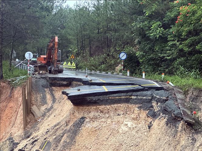
Arriving at Mimosa Pass at 10am on December 4, VNA reporters witnessed a serious traffic jam on the important pass leading to the gateway to Da Lat city (for trucks). At Km 226 of National Highway 20, the section passing through Mimosa Pass, the area that fell into the abyss on the night of November 19 has been temporarily repaired. Now, mud continues to slide down from the positive slope, burying the temporary road that was opened for temporary traffic on the evening of November 30.
Machinery from Hung Nguyen Limited Company is rushing to clear a large amount of dirt and rocks from the road surface. Meanwhile, on the negative slope, some machinery is still continuing to reinforce the roadbed to prevent subsidence. The company representative said that they will try to clear the pass by early this afternoon (around 13:00). Meanwhile, in 3 other locations, many pine trees were uprooted due to landslides, falling across the road. The authorities are rushing to saw the tree trunks to clear the road surface.
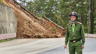
According to information from localities, on National Highway 20, the section passing through D'Ran Pass near Xeo Bridge, bordering Xuan Truong Ward - Da Lat and D'Ran Commune, also had serious landslides. On the morning of December 4, many people going to work and students going to school could not pass through the landslide section. Heavy rain caused landslides in some locations on Sacom Pass - Tuyen Lam Lake, Prenn Pass, and Song Pha Pass. However, vehicles can still move at limited speeds.
Meanwhile, National Highway 28 connecting Phan Thiet with Di Linh through Gia Bac Pass in Son Dien Commune ( Lam Dong ) has serious landslides in many locations. Mr. Vu Duc Nhuan, Chairman of Son Dien Commune People's Committee, said that landslides occurred on the entire pass. Specifically, at Km 38, 43, 45, 50, 51, 53, 61... landslides occurred, covering the entire road surface, cutting off traffic, and vehicles could not move.
Especially at km53, the amount of rock and soil that slid onto the road surface was up to 1,000 m3. The authorities had just cleared this location when another location collapsed again. The reason was that due to the heavy rain, the soil on the positive slope was saturated with water, becoming muddy and sliding from high to low, causing the above situation. Currently, the Traffic Police Teams at both ends of Gia Bac Pass are assigning officers and soldiers to be on duty to regulate traffic and guide vehicles not to go through Gia Bac Pass. It may take another 1-2 days to be able to pass through this route.
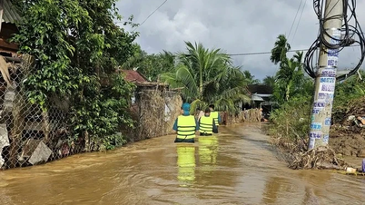
In many other localities, the exceptionally heavy rain on the night of December 3 caused many places to be flooded. Specifically, water from upstream caused National Highway 20 through the villages of Dinh An, K'Ren, K'Long (Hiep Thanh commune - Lam Dong) to be heavily flooded. Low-lying residential areas in these villages were flooded due to rising water. The rain and floods flooded more than 400 hectares of land and crops, over 70 houses were flooded 1.5 - 2.5 meters deep, 2 houses were damaged; the rain and floods caused landslides on 3 bridges. The authorities promptly evacuated 16 people, including many elderly people, sick people and children, from the danger zone, so there were no casualties. In Nam Ban commune - Lam Ha, there was also a major flood on the rivers, causing many houses to be flooded.
In Da Lat, heavy rain on the night of December 3 caused severe flooding in residential areas along Phan Dinh Phung stream in Cam Ly ward - Da Lat and Xuan Huong ward - Da Lat. Similarly, residential areas and flower gardens on Cach Mang Thang Tam, Trang Trinh, Truong Van Hoan streets... in Lam Vien ward - Da Lat were also severely flooded. However, by 6:00 a.m. on December 4, the water had basically receded. Currently, the rain has stopped in Da Lat urban area, with occasional sunshine. Traffic from the southern provinces to the provincial center was not much affected except for vehicles passing through Mimosa pass...
On the morning of December 4, floodwaters combined with heavy rains caused water levels to rise on National Highway 1A through Hong Son commune (Lam Dong) and many other national highways to be deeply flooded, making it impossible for vehicles to circulate.
According to local residents, from around 2am on December 4, floodwaters rose high on National Highway 1A through Hong Son Commune, making it impossible for vehicles to pass. Residents in the deeply flooded area were evacuated to safety by local forces. Authorities blocked both ends of the deeply flooded section of National Highway 1A to prevent vehicles from passing through.
Water from the Luy River rose, flooding National Highway 1A, from Km1658+100 to Km1658+750, in Luong Son commune. Here, the water flooded the road about 1 meter deep.
Heavy rains have flooded many sections of National Highway 28 in Ham Liem Commune, slowing down traffic. Currently, the flooded area of National Highway 28 is experiencing a traffic jam of about 3km.
Not only were the national highways flooded, heavy rains lasting from the afternoon of December 3 to the early morning of December 4 also caused landslides on the slope, flooding the Phan Thiet - Vinh Hao Expressway (Km215) in Ham Liem Commune. Here, the sand and soil on the slope collapsed onto the road surface about 20m, occupying 2 lanes. At the time of the incident, it was raining heavily, and vehicles were moving slowly. The functional units arranged a system of signs, cones, barriers, and organized road closures at Ma Lam intersection (Km208+600) to ensure traffic safety. Vehicles traveling on the expressway from the North must exit National Highway 28 at Ma Lam intersection.
Currently, local authorities of Lam Dong province are supporting evacuation and inspecting heavily flooded areas to have timely response plans.
Source: https://baotintuc.vn/xa-hoi/lam-dong-nhieu-tuyen-deo-quoc-lo-bi-sat-lo-ngap-sau-do-mua-lu-20251204115005259.htm
![[Photo] 60th Anniversary of the Founding of the Vietnam Association of Photographic Artists](/_next/image?url=https%3A%2F%2Fvphoto.vietnam.vn%2Fthumb%2F1200x675%2Fvietnam%2Fresource%2FIMAGE%2F2025%2F12%2F05%2F1764935864512_a1-bnd-0841-9740-jpg.webp&w=3840&q=75)


![[Photo] National Assembly Chairman Tran Thanh Man attends the VinFuture 2025 Award Ceremony](/_next/image?url=https%3A%2F%2Fvphoto.vietnam.vn%2Fthumb%2F1200x675%2Fvietnam%2Fresource%2FIMAGE%2F2025%2F12%2F05%2F1764951162416_2628509768338816493-6995-jpg.webp&w=3840&q=75)


Comment (0)