
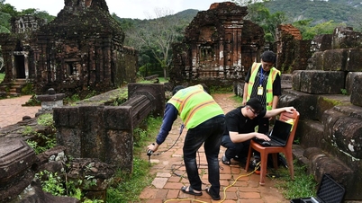
The My Son World Cultural Heritage Site Management Board has just released official information on the results of archaeological excavation and research on the architectural structure of the access road to the temple complex.
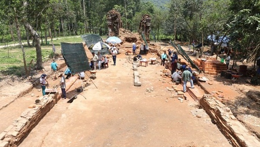
Accordingly, from July 2025, the My Son World Cultural Heritage Site Management Board, in coordination with the Institute of Archaeology, will carry out archaeological exploration and excavation in the area between Tower K and the central group of towers in the My Son temple complex (Thu Bon commune, Da Nang city).
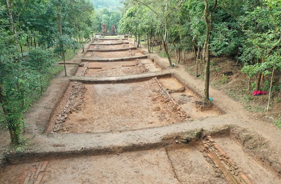
Prior to the 2025 excavation, exploratory excavations were conducted in the area around Tower K in 2023-2024. The results of these surveys and excavations have definitively identified the structure of the road leading from Tower K to the dry stream area to the east – approximately 150m from Tower K.
Experts believe this was a sacred path used by Brahman kings and priests to enter the central sacred space of the My Son sanctuary in the 12th century, a fact that is being discovered for the first time by domestic and international archaeological and historical researchers.
During the 2025 excavation, experts continued to expand the excavation area by an additional 770 m² to clarify the architectural remains. This excavation uncovered a 75m long section of the eastern access road to Tower K, oriented east-west with a 45-degree northward deviation, bringing the total area of the road clarified from the base of the tower to 132m.
Structurally, the road cross-section is 9m wide, with a carriageway width of 7.9m. The road surface is flat, composed of compacted sand, gravel, and broken bricks, with a thickness of 0.15 - 0.2m. The retaining walls on both sides of the road are constructed from rows of bricks, approximately over 1m high, reinforced with a layer of compacted gravel and brick powder. The walls are laid using a technique where the bricks are wider at the bottom and gradually narrow towards the top until they meet.
Along this route, during previous archaeological excavations, scientists discovered traces of two boundary walls. Now, with new evidence, archaeologists have identified five locations where gates were placed on the southern boundary wall.
At the gate location, there are still traces of stone gate beams with square mortise holes for erecting stone pillars and round mortise holes for placing the pivot of the gate leaf. These may have been gates leading from the path to and from the sacred space outside the road.
In particular, the fact that the ancient path ends at the dry stream bank may raise the question of whether, before entering the ceremonial area, kings, princes, and priests had to cross this stream as a "purification" ritual.
Regarding its age, based on the construction techniques of the road and comparing them with the wall sections within the overall architecture of Tower K, it can be concluded that the road dates back to the same period as Tower K, around the 12th century. The stratigraphic development of the site indicates that the road structure only existed during a specific cultural period and was soon forgotten after that period.
Besides the presence of bricks and stones used in the construction of the pathway, scientists also discovered several fragments of earthenware and glazed pottery dating from the 10th to the 12th centuries.
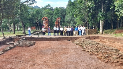
At the conference, experts and researchers unanimously agreed that the newly discovered site is indeed the sacred road – the site where important religious rituals of the ancient Champa people took place.
In the coming period, the My Son World Cultural Heritage Site Management Board and the Institute of Archaeology need to continue developing a collaborative research program to clarify the scale, structure, and appearance of the entire road within the overall context of the relic site; and carry out restoration and preservation work to better promote the historical and cultural value of the relic...
Source: https://congluan.vn/lo-dien-ro-net-con-duong-thieng-tai-thanh-dia-my-son-10322431.html
![[Photo] Prime Minister Pham Minh Chinh attends the Conference summarizing and implementing tasks of the judicial sector.](/_next/image?url=https%3A%2F%2Fvphoto.vietnam.vn%2Fthumb%2F1200x675%2Fvietnam%2Fresource%2FIMAGE%2F2025%2F12%2F13%2F1765616082148_dsc-5565-jpg.webp&w=3840&q=75)


![[Image] Close-up of the newly discovered "sacred road" at My Son Sanctuary](https://vphoto.vietnam.vn/thumb/402x226/vietnam/resource/IMAGE/2025/12/13/1765587881240_ndo_br_ms5-jpg.webp)


Comment (0)