
 |
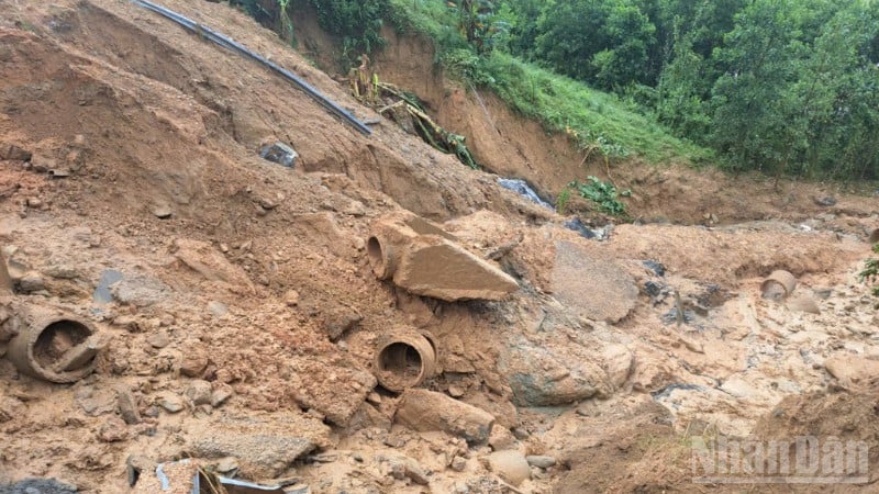
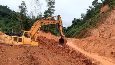
| Landslide on the East branch of Truong Son road. |
As of the morning of November 4, the western branch of Ho Chi Minh Road in the area of Road Management Area II had moderate to heavy rain, especially in the area from Ha Tinh to Hue city, it rained very heavily.
On the Ho Chi Minh Road West Branch, section Km109+150-Km109+200, a 50m long crack appeared along the cement concrete road surface, the widest crack was 20cm. Road Management Area II directed the management unit to set up barriers to ensure traffic safety.
In Hue city, there are 14 locations blocked by landslides on the positive and negative slopes from Km384+100 to Km408+350. The Vietnam Road Administration plans to clear these blocked locations on November 5, if the weather is favorable. Currently, the authorities have diverted traffic at both ends of the blocked locations.
The La Son-Hoa Lien section passing through Da Nang city is still congested, vehicles are being diverted by authorities to follow National Highway 1.
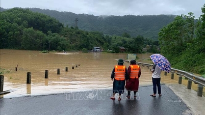
In Quang Tri province, many points on National Highway 1 and Ho Chi Minh Road were flooded 35-50 cm deep at Km679+300-Km697+030. Road maintenance units have placed warning signs and coordinated with the Traffic Police and Commune Police to divert traffic through the flood avoidance route at Km672+600 and Km704+900. In addition, the Km396+050 bridge on the western branch of Ho Chi Minh Road in Hue city was damaged and is being monitored and handled by Road Management Area II.
Road Management Area III (Central Highlands region) said that as of November 4, the area is still having rain, with a high risk of landslides.
At Lo Xo Pass on the Ho Chi Minh Highway, one lane of landslides has been opened to traffic, but the risk of further landslides is very high. Authorities recommend that vehicles travel along Highway 19 or 24 to connect the Central Highlands and Highway 1.
The West branch of Ho Chi Minh Road still has 6 traffic jams at Km415+230-Km433+620, expected to open one lane today (November 4).
Truong Son Dong Road still has 11 blocked locations, an increase of 1 location compared to November 3. In Da Nang city alone, there are 9 locations that are not yet cleared, of which 2 are completely blocked at Km112+350 and Km126+350. It is expected that one lane will be cleared by 5:00 p.m. on November 4.
Due to the continued heavy rain, the recovery work is facing many difficulties, the volume of landslides is large, and there is a risk of new ones arising. Authorities are guiding traffic through National Highway 1, Ho Chi Minh Road and local routes.
In Quang Ngai, the traffic jams on the eastern branch of Truong Son Street have been completely resolved. The total number of traffic jams in the entire Road Management Area III is 20, down 3 and with 2 new ones compared to November 3.
According to the Department of Construction of Quang Tri, as of 6 a.m. on November 4, there were still 7 traffic jams on national highways, including: 6 flooded locations, mainly on National Highway 9B, National Highway 9C and National Highway 49C, with flood levels from 0.2-0.7m; many sections where high-chassis cars can pass.
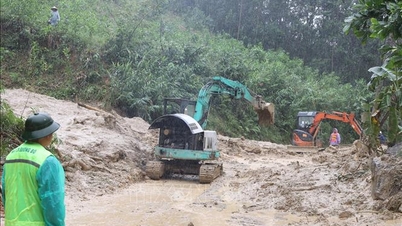
A landslide occurred at a location on National Highway 9C passing through Kim Ngan Commune, with a volume of about 1,000m³, and is being cleared. Several other locations on National Highways 9B, 9, 12C, 15 and 15D also suffered landslides, cracks and erosion of the road surface.
Management units have mobilized forces and means to initially overcome the situation, clear rocks, fallen trees, and ensure temporary traffic under weather conditions.
Road Management Areas and local authorities are continuing to be on duty, monitoring the developments of floods and rains, ready to respond, urgently overcome landslides and floods, ensuring smooth and safe traffic along the entire route.
Source: https://huengaynay.vn/kinh-te/xay-dung-giao-thong/nhieu-tuyen-duong-ho-chi-minh-va-quoc-lo-qua-mien-trung-tay-nguyen-van-bi-chia-cat-do-mua-lon-sat-lo-159592.html
![[Photo] Ho Chi Minh City Youth Take Action for a Cleaner Environment](https://vphoto.vietnam.vn/thumb/1200x675/vietnam/resource/IMAGE/2025/11/04/1762233574890_550816358-1108586934787014-6430522970717297480-n-1-jpg.webp)
![[Photo] Panorama of the Patriotic Emulation Congress of Nhan Dan Newspaper for the period 2025-2030](https://vphoto.vietnam.vn/thumb/1200x675/vietnam/resource/IMAGE/2025/11/04/1762252775462_ndo_br_dhthiduayeuncbaond-6125-jpg.webp)

![[Photo] Ca Mau "struggling" to cope with the highest tide of the year, forecast to exceed alert level 3](https://vphoto.vietnam.vn/thumb/1200x675/vietnam/resource/IMAGE/2025/11/04/1762235371445_ndo_br_trieu-cuong-2-6486-jpg.webp)

![[Photo] The road connecting Dong Nai with Ho Chi Minh City is still unfinished after 5 years of construction.](https://vphoto.vietnam.vn/thumb/1200x675/vietnam/resource/IMAGE/2025/11/04/1762241675985_ndo_br_dji-20251104104418-0635-d-resize-1295-jpg.webp)


Comment (0)